103.162.251.131 - IP Lookup: Free IP Address Lookup, Postal Code Lookup, IP Location Lookup, IP ASN, Public IP
Country:
Region:
City:
Location:
Time Zone:
Postal Code:
IP information under different IP Channel
ip-api
Country
Region
City
ASN
Time Zone
ISP
Blacklist
Proxy
Latitude
Longitude
Postal
Route
Luminati
Country
ASN
Time Zone
Asia/Jakarta
ISP
Universitas Sanata Dharma
Latitude
Longitude
Postal
IPinfo
Country
Region
City
ASN
Time Zone
ISP
Blacklist
Proxy
Latitude
Longitude
Postal
Route
IP2Location
103.162.251.131Country
Region
yogyakarta
City
yogyakarta
Time Zone
Asia/Jakarta
ISP
Language
User-Agent
Latitude
Longitude
Postal
db-ip
Country
Region
City
ASN
Time Zone
ISP
Blacklist
Proxy
Latitude
Longitude
Postal
Route
ipdata
Country
Region
City
ASN
Time Zone
ISP
Blacklist
Proxy
Latitude
Longitude
Postal
Route
Popular places and events near this IP address

Special Region of Yogyakarta
Special autonomous region of Indonesia
Distance: Approx. 650 meters
Latitude and longitude: -7.78333333,110.36666667
The Special Region of Yogyakarta is a province-level special region of Indonesia in southern Java. It is a semi-enclave that is surrounded by on the landward side by Central Java Province to the west, north, and east, but has a long coastline on the Indian Ocean to the south. Co-ruled by the Yogyakarta Sultanate and the Duchy of Pakualaman, the region is the only officially recognized diarchy within the government of Indonesia.
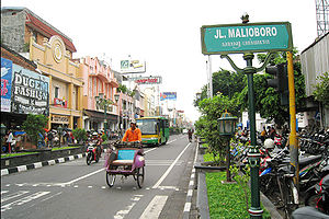
Jalan Malioboro
Major shopping street in Yogyakarta, Indonesia
Distance: Approx. 1294 meters
Latitude and longitude: -7.793359,110.365713
Jalan Malioboro (Javanese: ꦢꦭꦤ꧀ꦩꦭꦶꦪꦧꦫ, romanized: Dalan Maliyabara; English: Malioboro Street) is a major shopping street in Yogyakarta, Indonesia; the name is also used more generally for the neighborhood around the street. It lies north–south axis in the line between Yogyakarta Kraton and Mount Merapi. This is in itself is significant to many of the local population, the north–south orientation between the palace and the volcano being of importance.

Bethesda Hospital (Yogyakarta)
Hospital in Special Region of Yogyakarta, Indonesia
Distance: Approx. 1897 meters
Latitude and longitude: -7.783,110.378
Bethesda Hospital (Rumah Sakit Bethesda), founded in 1899, is the oldest hospital in Yogyakarta, Indonesia. It is managed by Yayasan Kristen untuk Kesehatan Umum (Yakkum, lit. 'Christian Foundation for General Health').
Panti Rapih Hospital
Hospital in Special Region of Yogyakarta, Indonesia
Distance: Approx. 1839 meters
Latitude and longitude: -7.77685,110.37635
Panti Rapih Hospital (Rumah Sakit Panti Rapih) is a private dis hospital in Yogyakarta, Indonesia. It was founded in 1929 by five sisters from St. Carolus Borromeus.
Duta Wacana Christian University
Private university in Yogyakarta, Indonesia
Distance: Approx. 1933 meters
Latitude and longitude: -7.78583333,110.37805556
Duta Wacana Christian University (DWCU) or Universitas Kristen Duta Wacana (UKDW) is a private university in Yogyakarta, central of Java island, Indonesia. "Duta Wacana" in Sanskrit conveys an approximate meaning of being 'an ambassador for knowledge' or 'a messenger of the word'. According to Webometrics World Universities' Ranking on the Web 2007, DWCU is ranked at 89th place among Southeast Asian universities.

Yogyakarta railway station
Railway station in Indonesia
Distance: Approx. 776 meters
Latitude and longitude: -7.7892485,110.363471
Yogyakarta Station (Indonesian: Stasiun Yogyakarta, Javanese: ꦱꦼꦠꦱꦶꦪꦸꦤ꧀ꦪꦺꦴꦒꦾꦏꦂꦠ, romanized: Setasiyun Yogyakarta), commonly known as Tugu Station (Javanese: ꦱꦼꦠꦱꦶꦪꦸꦤ꧀ꦠꦸꦒꦸ, romanized: Setasiyun Tugu; abbreviation YK, number 3020) is a railway station located in Yogyakarta, Special Region of Yogyakarta, in Indonesia. The altitude of this station is +113 m (371 ft) amsl. It is currently operated by the Operational Area VI Yogyakarta of Kereta Api Indonesia.

Lempuyangan railway station
Railway station in Indonesia
Distance: Approx. 1813 meters
Latitude and longitude: -7.7901989,110.3754443
Lempuyangan Station (Javanese: ꦱꦼꦠꦱꦶꦪꦸꦤ꧀ꦊꦩ꧀ꦥꦸꦪꦔꦤ꧀, romanized: Setasiyun Lempuyangan; LPN) is a railway station located in Bausasran, Danurejan, Yogyakarta, Indonesia. It is 1 kilometre (0.62 mi) east of Yogyakarta Station, 114 metres (374 ft) above sea level. The station is part of Operational Area VI Yogyakarta.

Grand Inna Malioboro
Historic hotel in Yogyakarta, Indonesia
Distance: Approx. 1086 meters
Latitude and longitude: -7.79060881,110.366698
The Grand Inna Malioboro is a historic colonial hotel in Yogyakarta, Indonesia. Established in 1908 as the Grand Hotel de Djokja, then when the Japanese Empire came to Yogyakarta, the hotel name was changed to Hotel Asahi, it was later known as the Hotel Merdeka, Natour Hotel Garuda, and Inna Garuda. It contains 223 rooms.
Sasana Wiratama
Distance: Approx. 1144 meters
Latitude and longitude: -7.78713,110.351395
Sasana Wiratama (Javanese: ꦱꦱꦤꦮꦶꦫꦠꦩ), also known as Museum Monumen Pangeran Diponegoro (Diponegoro Monument Museum; Javanese: ꦩꦸꦱꦶꦪꦸꦩ꧀ꦩꦺꦴꦤꦸꦩꦺꦤ꧀ꦥꦔꦺꦫꦤ꧀ꦢꦶꦥꦤꦼꦒꦫ, romanized: Musiyum Monumèn Pangéran Dipanegara) is a museum complex in Yogyakarta, Indonesia. The complex consists of a museum and a monument which commemorates the struggle of Prince Diponegoro, an 18th-century Javanese prince and a National Hero.

Dharma Wiratama Museum
Military museum in Yogyakarta, Indonesia
Distance: Approx. 1621 meters
Latitude and longitude: -7.782883,110.3755
Dharma Wiratama Museum, officially the Dharma Wiratama Central Army Museum (Indonesian: Museum Pusat TNI AD Dharma Wiratama) is a military museum centred on the history of the Indonesian Army from its inception in 1945 up through the coup of 30 September 1965 and Indonesian peacekeeping missions. It is located in the former national army headquarters in Yogyakarta.

Gedung Agung
Building in Gondomanan, Yogyakarta
Distance: Approx. 1983 meters
Latitude and longitude: -7.80022736,110.36454017
The Gedung Agung (English: The Great Building; Javanese: ꦒꦼꦝꦺꦴꦁꦄꦒꦼꦁ, romanized: Gedhong Ageng) is one of seven presidential palaces of Indonesia, it is located in the city of Yogyakarta. The palace complex covers an area of approximately 4.4 hectares. It is located in front of Fort Vredeburg.

Tugu Yogyakarta
Monument in Yogyakarta, Indonesia
Distance: Approx. 693 meters
Latitude and longitude: -7.78292063,110.36708537
Tugu Yogyakarta (Javanese: ꦠꦸꦒꦸꦔꦪꦺꦴꦒꦾꦏꦂꦠ, Tugu Ngayogyakarta) is an important historical pillar landmark in the city of Yogyakarta, Indonesia. Tugu means monument, which is usually built as a symbol of an area conceptualising characteristics of that region. Because of its historical background, Tugu Yogyakarta has become a historical icon of the city.
Weather in this IP's area
overcast clouds
24 Celsius
25 Celsius
24 Celsius
24 Celsius
1008 hPa
94 %
1008 hPa
994 hPa
10000 meters
1.22 m/s
1.53 m/s
273 degree
93 %

