103.162.218.31 - IP Lookup: Free IP Address Lookup, Postal Code Lookup, IP Location Lookup, IP ASN, Public IP
Country:
Region:
City:
Location:
Time Zone:
Postal Code:
ISP:
ASN:
language:
User-Agent:
Proxy IP:
Blacklist:
IP information under different IP Channel
ip-api
Country
Region
City
ASN
Time Zone
ISP
Blacklist
Proxy
Latitude
Longitude
Postal
Route
db-ip
Country
Region
City
ASN
Time Zone
ISP
Blacklist
Proxy
Latitude
Longitude
Postal
Route
IPinfo
Country
Region
City
ASN
Time Zone
ISP
Blacklist
Proxy
Latitude
Longitude
Postal
Route
IP2Location
103.162.218.31Country
Region
sumatera barat
City
bukittinggi
Time Zone
Asia/Jakarta
ISP
Language
User-Agent
Latitude
Longitude
Postal
ipdata
Country
Region
City
ASN
Time Zone
ISP
Blacklist
Proxy
Latitude
Longitude
Postal
Route
Popular places and events near this IP address

Bukittinggi
City in West Sumatra, Indonesia
Distance: Approx. 426 meters
Latitude and longitude: -0.30555556,100.36916667
Bukittinggi (Minangkabau: Bukiktinggi, Jawi: بوكيت تيڠڬي, formerly Dutch: Fort de Kock) is the third largest city in West Sumatra, Indonesia, with a population of 111,312 in 2010 and 121,028 in 2020. An official estimate as of mid 2023 lists a population of 124,047, consisting of 61,949 males and 62,098 females. The city covers an area of 25.24 km2.

Fort de Kock
19th-century Dutch sconce fortification
Distance: Approx. 1031 meters
Latitude and longitude: -0.30027778,100.36777778
Fort de Kock was a 19th-century Dutch sconce fortification established over a hill in Bukittinggi, West Sumatra, Indonesia. Around the fortification, a new settlement grew, which eventually grew into the city of Bukittinggi, the second largest city in West Sumatra. Although the remnants of the mound and some cannons can still be seen, the original buildings on top of the sconce have been demolished.
Baso (village)
Village in Indonesia
Distance: Approx. 9292 meters
Latitude and longitude: -0.28333333,100.45
Baso is a village in Agam Regency, West Sumatra, Indonesia. It is part of the nagari (settlement) of Tabek Panjang, in the kecamatan (sub-district) of Baso, located between the cities of Bukittinggi (15 km) and Payakumbuh.

Jam Gadang
Clocktower and landmark in West Sumatra, Indonesia
Distance: Approx. 448 meters
Latitude and longitude: -0.3052,100.3696
Jam Gadang (Minangkabau for "Big Clock") is a clock tower, major landmark, and tourist attraction in the city of Bukittinggi, West Sumatra, Indonesia. It is in the centre of the city, near the main market, Pasar Ateh. It has large clocks on each face.

Limpapeh Bridge
Bridge in Bukittinggi, West Sumatra
Distance: Approx. 967 meters
Latitude and longitude: -0.3007,100.3684
Limpapeh bridge is a bridge in over Ahmad Yani street, Bukittinggi, West Sumatra, Indonesia. This bridge has a length of 90 metres (300 ft) and width of 3.8 metres (12 ft). Fort de Kock fortification is connected to the Bukittinggi zoo by this bridge.

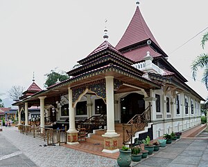
Jami Mosque of Taluak
Mosque in Agam, West Sumatra, Indonesia
Distance: Approx. 2857 meters
Latitude and longitude: -0.3278,100.38818
Jami Mosque of Taluak is one of the oldest mosques in Indonesia, located in Taluak IV Suku Nagari, Banuhampu District, Agam Regency, West Sumatra. The location of the mosque is close to the border of Bukittinggi, thus it is also known as Jamik Taluak Mosque Bukittinggi. Construction of the mosque was initiated by Haji Abdul Majid in 1860.

Nurul Iman Mosque of Koto Gadang
Mosque in Agam, West Sumatra, Indonesia
Distance: Approx. 1812 meters
Latitude and longitude: -0.3185,100.35730556
Nurul Iman Mosque of Koto Gadang or Tapi Koto Gadang Mosque is one of the oldest mosques in Indonesia, located in Koto Gadang Nagari, Agam Regency, West Sumatra. This mosque is the largest mosque in Koto Gadang area. Since its foundation in 1856, the mosque has undergone some form of transformation and several repairs.

Grand Mosque of Kubang Putih
Mosque in Kubang Putiah, West Sumatra, Indonesia
Distance: Approx. 4346 meters
Latitude and longitude: -0.333358,100.40119
Grand Mosque of Kubang Putih (Indonesian Masjid Raya Kubang Putih) is an early 19th-century mosque located in the town of Kubang Putiah, West Sumatra, Indonesia. The mosque is designated as a cultural heritage object along with several other old mosques in West Sumatra, such as Bingkudu Mosque in Agam, Rao Rao Mosque in Tanah Datar, and the Ganting Grand Mosque in Padang.
Lobang Jepang
Historical tourist attraction in West Sumatra
Distance: Approx. 747 meters
Latitude and longitude: -0.30309,100.36761
Lobang Jepang or Lubang Jepang (which means 'Japanese tunnel' or 'Japanese hole' in Indonesian) is an underground military complex, which is now one of the historical tourist attraction in the city of Bukittinggi, West Sumatra in Indonesia. The Japanese tunnel is a protection tunnel built by the Japanese occupying army around 1942 for defense purposes, which was fully completed in June, 1944. It was first discovered in the early 1950s and opened to tourists in 1994.
Weather in this IP's area
overcast clouds
19 Celsius
19 Celsius
19 Celsius
19 Celsius
1010 hPa
98 %
1010 hPa
907 hPa
10000 meters
0.61 m/s
0.6 m/s
105 degree
100 %
