Country:
 Australia
Region:
City:
Latitude and Longitude:
Time Zone:
Postal Code:
IP information under different IP Channel
ip-api
Country
Region
City
ASN
Time Zone
ISP
Blacklist
Proxy
Latitude
Longitude
Postal
Route
IPinfo
Country
Region
City
ASN
Time Zone
ISP
Blacklist
Proxy
Latitude
Longitude
Postal
Route
MaxMind
Country
Region
City
ASN
Time Zone
ISP
Blacklist
Proxy
Latitude
Longitude
Postal
Route
Luminati
Country
AUASN
Time Zone
Australia/Sydney
ISP
APIDT Infrastructure Pty Ltd
Latitude
Longitude
Postal
db-ip
Country
Region
City
ASN
Time Zone
ISP
Blacklist
Proxy
Latitude
Longitude
Postal
Route
ipdata
Country
Region
City
ASN
Time Zone
ISP
Blacklist
Proxy
Latitude
Longitude
Postal
Route
Popular places and events near this IP address
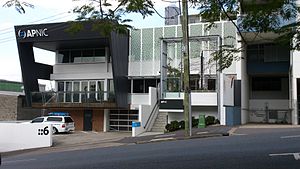
APNIC
Regional Internet registry for the Asia Pacific region
Distance: Approx. 10 meters
Latitude and longitude: -27.47315,153.0141
APNIC (the Asia Pacific Network Information Centre) is the regional Internet address registry (RIR) for the Asia–Pacific region. It is one of the world's five RIRs and is part of the Number Resource Organization (NRO). APNIC provides numbers resource allocation and registration services that support the global operation of the internet.

Merivale Bridge
Bridge in Queensland, Australia
Distance: Approx. 435 meters
Latitude and longitude: -27.4693,153.013
The Merivale Bridge is a double track railway bridge crossing the Brisbane River. It crosses the Milton Reach of the river, located in between the Go Between Bridge and the William Jolly Bridge. Exclusively a railway crossing, it is located between the stations of South Brisbane and Roma Street, linking the northern and southern elements of the Queensland Rail City network.

Brisbane Trades Hall
Building in Brisbane, Queensland
Distance: Approx. 293 meters
Latitude and longitude: -27.472725,153.01694722
The Brisbane Trades Hall is a former Trades Hall building in Edward Street, Brisbane, Queensland, Australia.
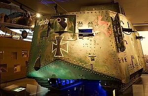
Mephisto (tank)
Last surviving German A7V tank (WWI-era)
Distance: Approx. 385 meters
Latitude and longitude: -27.47299167,153.01790278
Mephisto is a World War I German tank, the only surviving example of an A7V. In April 1918, during a German attack at Villers-Bretonneux on the Western Front, it became stuck in a shell-hole and was abandoned by its crew. It was recovered by Allied troops about three months later and, after the war, taken to Australia as a trophy. Mephisto is housed at the Queensland Museum, in Brisbane, in the Anzac Legacy Gallery.
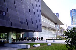
Gallery of Modern Art, Brisbane
Art museum in Queensland, Australia
Distance: Approx. 423 meters
Latitude and longitude: -27.470606,153.017235
The Gallery of Modern Art (GOMA) is an art museum located within the Queensland Cultural Centre in the South Bank precinct of Brisbane, Queensland, Australia. The gallery is part of QAGOMA. Opened on 2 December 2006, the GOMA is the largest gallery of modern and contemporary art in Australia, and houses Australia's first purpose-built cinematheque. The gallery is situated on Kurilpa Point next to the Queensland Art Gallery (QAG) building and the State Library of Queensland, and faces the Brisbane River and the CBD. The GOMA has a total floor area over 25,000 square metres (270,000 sq ft) and the largest exhibition gallery is 1,100 square metres (12,000 sq ft).

Go Between Bridge
Bridge in Brisbane, Queensland, Australia
Distance: Approx. 415 meters
Latitude and longitude: -27.46972222,153.01222222
The Go Between Bridge, formerly known as the Hale Street Link, is a toll bridge for vehicles, pedestrians and cyclists over the Brisbane River in inner-city Brisbane, Queensland, Australia. The bridge connects Merivale and Cordelia Streets in West End to Hale Street and the Inner City Bypass at Milton. It is Brisbane's first inner-city traffic bridge in 40 years and carries around 12,000 vehicles per day.

A1 @ SW1 South Bank
Building in Brisbane, Australia
Distance: Approx. 367 meters
Latitude and longitude: -27.4757,153.0163
The A1 is an eight-storey building that is located at SW1 on the South Bank of the Brisbane River in Brisbane, Queensland, Australia. The building was designed by Allen Jack+Cottier architects, in association with Cox Rayner, and the building comprises ground floor housing retail and services and seven storeys above being used as commercial spaces. SW1 consist of six residential buildings and four commercial towers with retail nodes.

Queensland National Bank, South Brisbane
Historic site in Queensland, Australia
Distance: Approx. 414 meters
Latitude and longitude: -27.4739,153.0181
Queensland National Bank Building is a heritage-listed former bank at 39 Melbourne Street, South Brisbane, Queensland, Australia. It was designed by Addison & MacDonald and built in 1929 by Albert Stonadge & Son. It is also known as Ng House.

St Mary's Church, South Brisbane
Church in Australia
Distance: Approx. 155 meters
Latitude and longitude: -27.4739,153.0153
St Mary's Church is a heritage-listed Roman Catholic church at 20 Merivale Street (corner of Peel Street), South Brisbane, Queensland, Australia. It was designed by Simkin and Ibler and built from 1892 to 1929. It was added to the Queensland Heritage Register on 3 December 2004.

Coronation Hotel
Historic site in Queensland, Australia
Distance: Approx. 252 meters
Latitude and longitude: -27.4712,153.0154
Coronation Hotel is a heritage-listed hotel at 46 Montague Road, South Brisbane, Queensland, Australia. It was designed by Francis Drummond Greville Stanley and built in 1891. It is also known as Montague Hotel.
Murder of Sophie Collombet
2014 murder in Brisbane, Australia
Distance: Approx. 433 meters
Latitude and longitude: -27.4699,153.0165
On 27 March 2014, 21-year-old French student Sophie Collombet was raped and bludgeoned to death in Kurilpa Point Park in Brisbane, Queensland, Australia. She had been on her way home from a three-hour lecture at Griffith University where she was studying her Masters of Business. On 7 April Australian citizen Benjamin James Milward from Ipswich, Queensland was arrested and charged with her murder and rape.
Bille Brown Theatre
Theatre in Brisbane, Australia
Distance: Approx. 125 meters
Latitude and longitude: -27.471995,153.014215
The Bille Brown Theatre is a 351-seat theatre at 78 Montague Road, South Brisbane, Brisbane, Queensland, Australia. The theatre is a corner-stage with raked seating on three sides. It is the main venue for Queensland Theatre.
Weather in this IP's area
scattered clouds
16 Celsius
16 Celsius
14 Celsius
17 Celsius
1020 hPa
95 %
1020 hPa
1019 hPa
10000 meters
0.45 m/s
0.45 m/s
311 degree
40 %
05:10:54
17:55:48