103.160.232.34 - IP Lookup: Free IP Address Lookup, Postal Code Lookup, IP Location Lookup, IP ASN, Public IP
Country:
 India
IndiaRegion:
City:
Location:
Time Zone:
Postal Code:
ISP:
ASN:
language:
User-Agent:
Proxy IP:
Blacklist:
IP information under different IP Channel
ip-api
Country
Region
City
ASN
Time Zone
ISP
Blacklist
Proxy
Latitude
Longitude
Postal
Route
db-ip
Country
Region
City
ASN
Time Zone
ISP
Blacklist
Proxy
Latitude
Longitude
Postal
Route
IPinfo
Country
Region
City
ASN
Time Zone
ISP
Blacklist
Proxy
Latitude
Longitude
Postal
Route
IP2Location
103.160.232.34Country
inRegion
kerala
City
kotamangalam
Time Zone
Asia/Kolkata
ISP
Language
User-Agent
Latitude
Longitude
Postal
ipdata
Country
Region
City
ASN
Time Zone
ISP
Blacklist
Proxy
Latitude
Longitude
Postal
Route
Popular places and events near this IP address

Kothamangalam, Kerala
Municipality in Kerala, India
Distance: Approx. 4156 meters
Latitude and longitude: 10.0683,76.59542
Kothamangalam ([koːd̪ɐmɐŋgɐlɐm]) is a municipality at the foot of the Western Ghats in the Ernakulam district of Kerala, India. It is located 42 km (26.1 mi) east of the district collectorate in Thrikkakara and about 218 km (135.5 mi) north of the state capital Thiruvananthapuram. As per the 2011 Indian census, Kothamangalam has a population of 38,837 people, and a population density of 969/km2 (2,510/sq mi).

Keerampara
Village in Kerala, India
Distance: Approx. 5207 meters
Latitude and longitude: 10.1,76.66666667
Keerampara is an Indian village in the state of Kerala, India. This is a junction. This place is once blessed with the footprints of all the holy personnel who passed through the Royal route (from Madurai to Kothamangalam).

Nangelil Ayurveda Medical College
Medical college in Kerala, India
Distance: Approx. 3366 meters
Latitude and longitude: 10.0676,76.6026
Nangelil Ayurveda Medical College is an ayurvedic medical college, located in Kothamangalam, in the Ernakulam district of Kerala, India. The college, owned by the Nangelil Charitable Trust, is self-financing, and is affiliated to Kerala University Of Health Sciences, Thrissur and associated with Nangelil Ayurveda Medical College Hospital, Kothamangalam. The college offers a five-year Bachelor of Ayurvedic Medicine And Surgery course, approved by Kerala University of Health science, Trichur.
Kottappady
Village in Kerala, India
Distance: Approx. 3650 meters
Latitude and longitude: 10.06666667,76.6
Kottappady is a village in Kothamangalam Taluk in Ernakulam district of Kerala State, India. It belongs to Central Kerala Division. It is located 10 km from Kothamangalam.
Thrikkariyoor
Village in Kerala, India
Distance: Approx. 1823 meters
Latitude and longitude: 10.06666667,76.61666667
Thrikariyoor is a village in Nellikuzhi panchayath in Ernakulam district in the Indian state of Kerala. Thrikkariyoor Mahadeva Temple is nearby.
Pezhakkappilly
Town in Kerala, India
Distance: Approx. 5241 meters
Latitude and longitude: 10.025,76.61111111
Pezhakkappilly is a suburb of Muvattupuzha town in Ernakulam district, Kerala, India, to the northwest of the town of Muvattupuzha. Its main junctions are Paipra Kavala, Sabine Junction, Pallichirangara, and Pallipady. Pezhakkappilly is situated along MC Road, and has seen rapid urbanization and growth in recent years.
Vimalagiri Public School, Kothamangalam
School in Kerala, India
Distance: Approx. 2095 meters
Latitude and longitude: 10.0587,76.616
Vimalagiri Public School is an educational institution in Kothamangalam, Kerala. It is affiliated to CBSE, Delhi. The school was founded by Msgr Fr.
Nellikuzhi
Distance: Approx. 5781 meters
Latitude and longitude: 10.08333333,76.58333333
Nellikuzhi is a Grama panchayat in Kothamangalam Taluk, Ernakulam district, Kerala, situated on the Aluva-Munnar State Highway. Nellikuzhi is famous for its furniture business. There are hundreds of furniture showrooms and thousands of production units.
Greenvalley Public School
Private elementary and secondary school in Nellikuzhi, Kothamangalam, Kerala, India
Distance: Approx. 3539 meters
Latitude and longitude: 10.0745,76.602
Greenvalley Public School is an educational institution in Nellikuzhi, Kothamangalam, in the state of Kerala, India. It is affiliated to Central Board of Secondary Education, New Delhi, for AISSE (Grade 10) and AISSCE (Grade 12) examinations. It was established in 1996 by Molly Pradeep, late wife of the present director, Pradeep Kuriakose.

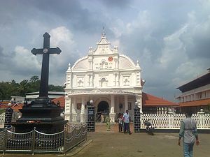
St. Mary's Jacobite Syrian Cathedral, Kothamangalam
Church in Ernakulam, India
Distance: Approx. 436 meters
Latitude and longitude: 10.0642781,76.6301738
Martha Mariyam Cathedral or St. Mary's Church is a prominent Valiyapally (Principal Church) of the Syriac Orthodox Church situated in Kothamangalam town in the Ernakulam district of Kerala, India. It is one of the earliest Christian churches in India.
Marthoman Cheriyapally, Kothamangalam
Church in Ernakulam, India
Distance: Approx. 664 meters
Latitude and longitude: 10.0625,76.629
Mar Thoma Cheriyapally is a Jacobite Syrian Orthodox Church located in Kothamangalam town of Ernakulam district, Kerala, India. The church is believed to have been established in 1455 by 18 families who separated from Marth Maryam Valiyapally. The church is famous for the feast of Mor Baselios Yeldo, a Syriac Jacobite saint who preached in Kothamangalam.

Thrikkariyoor Mahadeva Temple
Hindu temple in India
Distance: Approx. 3027 meters
Latitude and longitude: 10.084759,76.612658
Thrikkariyoor Mahadeva Temple is located in the town of Kothamangalam in Ernakulam district, on the northern bank of Kothayar river, a tributary of Muvattupuzha river. It is believed that this temple is one of the 108 Shiva temples of Kerala and is considered to be the last temple installed by sage Parasurama dedicated to Shiva. Thrikkariyoor (Karuvoor or Karaorai), believed to be the headquarters of Adi Cheras kings, is famous for its historical significance and legends.
Weather in this IP's area
broken clouds
22 Celsius
21 Celsius
22 Celsius
22 Celsius
1014 hPa
38 %
1014 hPa
1008 hPa
10000 meters
0.49 m/s
0.87 m/s
95 degree
70 %