Country:
Region:
City:
Latitude and Longitude:
Time Zone:
Postal Code:
IP information under different IP Channel
ip-api
Country
Region
City
ASN
Time Zone
ISP
Blacklist
Proxy
Latitude
Longitude
Postal
Route
Luminati
Country
ASN
Time Zone
Asia/Kolkata
ISP
AMAZON-02
Latitude
Longitude
Postal
IPinfo
Country
Region
City
ASN
Time Zone
ISP
Blacklist
Proxy
Latitude
Longitude
Postal
Route
db-ip
Country
Region
City
ASN
Time Zone
ISP
Blacklist
Proxy
Latitude
Longitude
Postal
Route
ipdata
Country
Region
City
ASN
Time Zone
ISP
Blacklist
Proxy
Latitude
Longitude
Postal
Route
Popular places and events near this IP address

Hutatma Chowk
Square in Mumbai, Maharashtra, India
Distance: Approx. 465 meters
Latitude and longitude: 18.932431,72.831502
Hutatma Chowk ("Martyrs' Square, officially, Hutatma Smarak Chowk, "Martyrs Memorial Square") is a square in South Mumbai, Maharashtra, India. The square hosts Flora Fountain and was known by that name until 1961 when it was officially renamed in memory of the members of Samyukta Maharashtra Samiti, who died when police fired upon their peaceful demonstration in 1956. A statue of a "Martyr with a Flame" stands next to Flora Fountain.

Cross Maidan
Open ground in Mumbai
Distance: Approx. 209 meters
Latitude and longitude: 18.936297,72.829742
Cross Maidan (formerly Parade Ground ) is a vast expanse of land in Mumbai. The term maidan means "playing ground" in Marathi. The ground measures 23,000 m2.

Fashion Street
Shopping district in Mumbai, India
Distance: Approx. 213 meters
Latitude and longitude: 18.937982,72.8303
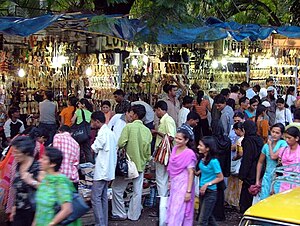
Fashion Street refers to a cluster of over 385 street side clothing shops on MG Road near Azad Maidan and is opposite to Bombay Gymkhana, in South Mumbai, India. The market is located just opposite VSNL office building at Mahatma Gandhi Road (MG Road). It is a popular tourist destination, and is known for bargaining.

Bombay Gymkhana
Gymkhana in Mumbai, India
Distance: Approx. 106 meters
Latitude and longitude: 18.93743056,72.83121111
The Bombay Gymkhana, established in 1875, is a premier private members' club in the city of Mumbai, India. It is located at the triangular end of Azad Maidan in the Fort area of South Mumbai and is in close proximity of Chhatrapati Shivaji Maharaj Terminus. It was originally built as a British-only gentlemen's club, designed by English architect, Claude Batley.

Cathedral and John Connon School
Cathedral school in South Mumbai, Maharashtra, India
Distance: Approx. 127 meters
Latitude and longitude: 18.936178,72.832825
The Cathedral and John Connon School is a co-educational private school founded in 1860 and located in Fort, Mumbai, Maharashtra. The school is widely considered to be amongst the best and most prestigious schools in India, housing five sections: Pre-Primary, Infant, Junior, Middle and Senior Schools. The school also controls the 300-year-old St.

Azad Maidan
Sports ground in Mumbai, India
Distance: Approx. 409 meters
Latitude and longitude: 18.940278,72.831667
Azad Maidan (formerly known as Bombay Gymkhana Maidan) is a triangular-shaped maidan (sports ground) in the city of Mumbai, India. It is located on 25 acres (10 ha) of land near the Chhatrapati Shivaji Terminus station. It is a regular venue for inter-school cricket matches.
Chemould Prescott Road
Contemporary Art Gallery in Fort, Mumbai
Distance: Approx. 100 meters
Latitude and longitude: 18.9359,72.8323
Chemould Prescott Road, founded (as Gallery Chemould), is the first contemporary art gallery in Mumbai, India.
J.B. Petit High School for Girls
Private school in Mumbai, India
Distance: Approx. 216 meters
Latitude and longitude: 18.93466,72.83182
J.B. Petit High School is a private all-girls school in the Fort neighbourhood of Mumbai, Maharashtra, India established in 1865. The school currently offers the ICSE board. The school is named after Jehangir Bomanji Petit.

St. Xavier's Boys' Academy, Mumbai
Private primary and secondary school in Marine Lines, Mumbai, Maharashtra, India
Distance: Approx. 393 meters
Latitude and longitude: 18.93583333,72.82805556
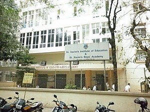
St. Xavier's Boys' Academy, Mumbai (abbreviated as SXBA) is a private primary and secondary school for boys located in Marine Lines, Mumbai, Maharashtra, India. The school was established by the Jesuits in June 1957 and caters to students enrolled from Jr Kg through 10.

Parsi Lying-in Hospital
Hospital in Maharashtra, India
Distance: Approx. 123 meters
Latitude and longitude: 18.935883,72.832588
The Parsi Lying-in Hospital (PLIH), also known as Temulji's Lying-in Hospital, sometimes spelled Tehmulji's Lying-in Hospital, was one of the first maternity hospitals in Bombay (now Mumbai). It was co-founded by physician and obstetrician Temulji Bhicaji Nariman in 1887 and completed in 1895. Dwindling numbers of Parsi births in the latter half of the 20th century led to its closure.
J. N. Petit Library
Membership library in Mumbai, India
Distance: Approx. 245 meters
Latitude and longitude: 18.9345,72.8324
The J. N. Petit Library (officially the J. N. Petit Institute) is a membership library in a Grade II heritage structure in Fort, Mumbai. It was founded in 1898 by a group of Parsi students studying at Elphinstone College. Membership is open to residents of Mumbai.
Alexandra Girls' English Institution
Private school in Mumbai, Maharashtra, India
Distance: Approx. 151 meters
Latitude and longitude: 18.93527778,72.83138889
The Alexandra Girls' English Institution (commonly abbreviated as the AGEI), formerly known as the Alexandra Native Girls' English Institution, is a girls-only school in Mumbai, Maharashtra, India. Established on 1 September 1863 by Manockjee Cursetjee at his residence Villa Byculla, the institution is named after Princess Alexandra, who became the Princess of Wales upon her marriage to Albert Edward, Prince of Wales on 10 March 1863. The school was later moved to its present location at Hazarimal Somani Marg.
Weather in this IP's area
smoke
27 Celsius
27 Celsius
27 Celsius
27 Celsius
1011 hPa
50 %
1011 hPa
1010 hPa
2500 meters
2.57 m/s
40 degree
06:43:53
18:01:40