Country:
Region:
City:
Latitude and Longitude:
Time Zone:
Postal Code:
IP information under different IP Channel
ip-api
Country
Region
City
ASN
Time Zone
ISP
Blacklist
Proxy
Latitude
Longitude
Postal
Route
Luminati
Country
ASN
Time Zone
Asia/Kolkata
ISP
INNOVATIVE FIBER SOLUTIONS PRIVATE LIMITED
Latitude
Longitude
Postal
IPinfo
Country
Region
City
ASN
Time Zone
ISP
Blacklist
Proxy
Latitude
Longitude
Postal
Route
db-ip
Country
Region
City
ASN
Time Zone
ISP
Blacklist
Proxy
Latitude
Longitude
Postal
Route
ipdata
Country
Region
City
ASN
Time Zone
ISP
Blacklist
Proxy
Latitude
Longitude
Postal
Route
Popular places and events near this IP address
Panchkula district
District of Haryana in India
Distance: Approx. 926 meters
Latitude and longitude: 30.69,76.86
Panchkula district was formed as the 17th district of the Indian state of Haryana on 15 August 1995. It comprises two sub divisions and two tehsils: Panchkula and Kalka. It has 264 villages, out of which 12 are uninhabited and ten wholly merged with towns or treated as census towns according to the 1991 census.
The British School, Panchkula
Senior secondary school in Panchkula, India
Distance: Approx. 1187 meters
Latitude and longitude: 30.6978,76.8434
The Bharat School in Panchkula, India is an international school, affiliated to Central Board of Secondary Education. The school is up to Senior Secondary offering Humanities and Commerce. The Bharat School, Panchkula is run under the aegis of Urmila T. R. Sethi Global Foundation.
Nada Sahib
Gurdwara in Haryana India
Distance: Approx. 2888 meters
Latitude and longitude: 30.694,76.88
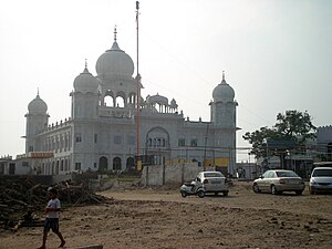
Nada Sahib is a Sikh gurudwara in the Panchkula district of the Indian state of Haryana. Situated on the banks of the Ghaggar-Hakra River in the Sivalik Hills of Panchkula, it is the site where Guru Gobind Singh Ji halted while travelling from Paonta Sahib to Anandpur Sahib after the Battle of Bhangani in 1688.
Mani Majra
Sector 13, Chandigarh, India
Distance: Approx. 3723 meters
Latitude and longitude: 30.71916667,76.83361111
Sector 13 is a commercial and residential hub of Chandigarh, consisting of posh housing areas, residential colonies, IT parks, Malls, Schools, Hotels and cultural complexes. Manimajra and adjoining urban areas developed by Chandigarh administration were reconstituted as Sector 13. Old Manimajra is a historical Puadhi Dialect town which was established by the Gharib Dass Dhillon as the capital of the newly created princely state, Manimajra State.
Shivalik Enclave
Residential & Commercial in India
Distance: Approx. 2425 meters
Latitude and longitude: 30.70916667,76.84083333
Shivalik Enclave is situated between older sections of ManiMajra (also known as Manimajra Town) of Sector 13, Chandigarh, and Panchkula. It is located on Kalka-Shimla Road next to the Housing Board Light Point. Shivalik Enclave is a part of Chandigarh and one of its boundaries touches the Haryana border at Panchkula.

National Cactus and Succulent Botanical Garden and Research Centre
Distance: Approx. 978 meters
Latitude and longitude: 30.697767,76.85106
The National Cactus and Succulent Botanical Garden and Research Centre, known as the Cactus Garden, is a 7 acres (2.8 ha) cactus garden in Sector 5 of Panchkula, Haryana, India , was established in 1987, and is known for its rare and endangered species of Indian succulent plants.
Tau Devi Lal Cricket Stadium
Distance: Approx. 1624 meters
Latitude and longitude: 30.6856,76.8669
Tau Devi Lal Stadium is a multi-sport complex in located in Sector 3, Panchkula, a satellite town in the outskirts of Chandigarh. The stadium is capable of holding around 7,000 spectators and came into picture because of the Indian Cricket League's inaugural Twenty20 tournament. The stadium has been leased by Government of Haryana.

Panchkula Assembly constituency
Constituency of the Haryana legislative assembly in India
Distance: Approx. 2512 meters
Latitude and longitude: 30.71,76.86
Panchkula Assembly constituency is one of the 90 assembly seats of Haryana in the Panchkula district of Haryana, India. It is under Ambala (Lok Sabha constituency). It forms a part of a continuous area with the Union Territory of Chandigarh and the city of Mohali.
Manimajra Fort
Fort situated in Mani Majra town of Chandigarh city
Distance: Approx. 3101 meters
Latitude and longitude: 30.71444444,76.83722222
Manimajra Fort, is a fort situated in Mani Majra, Chandigarh (city of Indian Union). It is over 360 years old and has become more popular with the shooting of the Oscar-winning movie Zero Dark Thirty. It was built by Gharib Dass Dhillon of Dhillon clan as the capital of his newly created state of 84 villages.

Haryana State Industrial and Infrastructure Development Corporation
Indian state-owned agency
Distance: Approx. 1935 meters
Latitude and longitude: 30.706103,76.853988
Haryana State Industrial and Infrastructure Development Corporation (HSIIDC) (established 8 March 1967), formerly Haryana State Industrial Development Corporation (HSIDC), headquartered at Panchkula, is a 100% state-owned agency of the government of Haryana in the Indian state of Haryana. For ease of doing business, Haryana is the first state in India to introduce a labour policy in 2005 and Land Pooling Policy in 2017, for which HSIIDC acts as the nodal agency. Haryana Financial Corporation provides financial assistance for setting up new industrial units and for the expansion and diversification of the existing industries.
Tau Devi Lal Athletic Stadium (Panchkula)
Distance: Approx. 1903 meters
Latitude and longitude: 30.685,76.86972222
Tau Devi Lal Stadium is a multi-purpose stadium located in Sector 3, Panchkula, a satellite town in the outskirts of Chandigarh. It is the home ground of the Indian Super League side RoundGlass Punjab FC, together with Guru Nanak Stadium. It was also used as home ground by AIFF XI in the I-League.
Gurdwara Khooni Sahib
Historical and holy place in India
Distance: Approx. 3396 meters
Latitude and longitude: 30.71946,76.84844
Sri Khooni Sahib is a gurudwara in Manimajra, a small town in Chandigarh, India. The gurdwara is located about one kilometer from the famous Mata Mansa Devi Temple, a Hindu temple. It is located in Manimajra village Bhansa Tibba.
Weather in this IP's area
overcast clouds
28 Celsius
27 Celsius
28 Celsius
28 Celsius
1014 hPa
28 %
1014 hPa
977 hPa
10000 meters
3.07 m/s
3.28 m/s
296 degree
100 %
06:49:06
17:25:34


