Country:
Region:
City:
Latitude and Longitude:
Time Zone:
Postal Code:
IP information under different IP Channel
ip-api
Country
Region
City
ASN
Time Zone
ISP
Blacklist
Proxy
Latitude
Longitude
Postal
Route
Luminati
Country
ASN
Time Zone
Asia/Kolkata
ISP
Sri Vari Network Private Limited
Latitude
Longitude
Postal
IPinfo
Country
Region
City
ASN
Time Zone
ISP
Blacklist
Proxy
Latitude
Longitude
Postal
Route
db-ip
Country
Region
City
ASN
Time Zone
ISP
Blacklist
Proxy
Latitude
Longitude
Postal
Route
ipdata
Country
Region
City
ASN
Time Zone
ISP
Blacklist
Proxy
Latitude
Longitude
Postal
Route
Popular places and events near this IP address
Bharathiar University
State-run university in Coimbatore, Tamil Nadu
Distance: Approx. 7165 meters
Latitude and longitude: 11.03976944,76.87881111
Bharathiar University is a public state university in Coimbatore, Tamil Nadu, India. Named after Tamil poet Subramania Bharati, the university was established in February 1982 under the provision of Bharathiar University Act, 1981 (Act 1 of 1982) and was recognized by the University Grants Commission (UGC) in 1985. Bharathiar University celebrated its silver jubilee celebrations on 24 February 2007.

Government Law College, Coimbatore
Indian law college
Distance: Approx. 6727 meters
Latitude and longitude: 11.042886,76.867931
The Government Law College, Coimbatore is a public law college in the state of Tamil Nadu, India. Like the rest of the law colleges in Tamil Nadu, it is administered by Tamil Nadu's Department of Legal Studies, and affiliated to Tamil Nadu Dr. Ambedkar Law University.

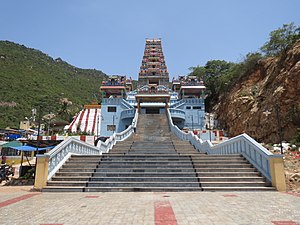
Maruthamalai Marudhachalamurthy Temple
Hindu temple in Coimbatore, Tamil Nadu, India
Distance: Approx. 6327 meters
Latitude and longitude: 11.04611111,76.85194444
Subramaniya Swamy Temple, Marudhamalai (also Maruthamalai or Marudamalai), or the Marudhamalai Murugan Temple, is a popular 12th-century hill temple situated in Coimbatore, Tamil Nadu, India. Built by Tamil kings during the Sangam period as indicated in the Purananuru, the temple is dedicated to Lord Murugan and is considered the Seventh House of Lord Murugan. Like most Murugan temples, the temple is situated upon a hill, part of the Western Ghats about 12 km west from the centre of the city of Coimbatore.
Dhaliyur
Suburb in Coimbatore, Tamil Nadu, India
Distance: Approx. 2613 meters
Latitude and longitude: 11.01055556,76.84944444
Dhaliyur is a panchayat town in Coimbatore district in the state of Tamil Nadu, India. Dhaliyur is a western suburb of Coimbatore city. It lies close to Kerala State border.
Pooluvapatti
Suburb of Coimbatore, Tamil Nadu, India
Distance: Approx. 5208 meters
Latitude and longitude: 10.94972222,76.81416667
Pooluvapatti is a panchayat town in Coimbatore district in the Indian state of Tamil Nadu. It is a western suburb of Coimbatore and lies close to Kerala border. Pooluvapatti comes under Coimbatore Municipal Corporation.
Thenkarai, Coimbatore
Coimbatore, Tamil Nadu, India
Distance: Approx. 4985 meters
Latitude and longitude: 10.9475,76.8425
Thenkarai is a suburban area near Coimbatore City Municipal Corporation, in the Indian state of Tamil Nadu. It is in the western suburbs of Coimbatore. It recently merged with the Coimbatore Corporation limits.
Thondamuthur
Coimbatore, Tamil Nadu, India
Distance: Approx. 2153 meters
Latitude and longitude: 11.00972222,76.82805556
Thondamuthur is a suburb of Coimbatore city in the Indian state of Tamil Nadu. It comes under the Coimbatore Corporation. Thondamuthur is located 15 km west from the District headquarters Coimbatore, there are three routes available to reach Thondamuthur, through Vadavalli (15 km), through Perur (15 km), through Gandhi park, Vedapatti (14 km).
Vedapatti
Suburb in Kongu Nadu, Tamil Nadu, India
Distance: Approx. 6479 meters
Latitude and longitude: 11,76.89388889
Vedapatti is a suburb of Coimbatore in the Indian state of Tamil Nadu. It is the western suburb of Coimbatore, which was included with the Coimbatore Corporation limits in 2011.
Coimbatore Institute of Engineering and Technology
Engineering college in Tamil Nadu, India
Distance: Approx. 6764 meters
Latitude and longitude: 10.995504,76.773427
Coimbatore Institute of Engineering and Technology (CIET), is a private self-financing Engineering college located in Coimbatore, Tamil Nadu, India. It was established in 2001 by the Kovai Kalaimagal Educational Trust.

Thondamuthur Assembly constituency
One of the 234 State Legislative Assembly Constituencies in Tamil Nadu, in India
Distance: Approx. 2153 meters
Latitude and longitude: 11.00972222,76.82805556
Thondamuthur is a legislative assembly in Coimbatore district in Tamil Nadu, which includes the town, Thondamuthur. Its State Assembly Constituency number is 119. Thondamuthur assembly constituency is part of Pollachi Lok Sabha constituency.
Thondamuthur Block
Distance: Approx. 2153 meters
Latitude and longitude: 11.00972222,76.82805556
Thondamuthur block is a revenue block of Coimbatore district of the Indian state of Tamil Nadu. This revenue block consist of 10 panchayat villages.
Uliyampalayam
Neighborhood in Kongu Nadu, Tamil Nadu, India
Distance: Approx. 3140 meters
Latitude and longitude: 11.00817,76.858526
Uliyampalayam is a neighborhood in Coimbatore in the Indian state of Tamil Nadu. It is located near Thondamuthur.
Weather in this IP's area
broken clouds
23 Celsius
23 Celsius
23 Celsius
23 Celsius
1012 hPa
87 %
1012 hPa
961 hPa
10000 meters
1.51 m/s
1.44 m/s
31 degree
57 %
06:15:35
17:57:01