103.153.164.59 - IP Lookup: Free IP Address Lookup, Postal Code Lookup, IP Location Lookup, IP ASN, Public IP
Country:
Region:
City:
Location:
Time Zone:
Postal Code:
ISP:
ASN:
language:
User-Agent:
Proxy IP:
Blacklist:
IP information under different IP Channel
ip-api
Country
Region
City
ASN
Time Zone
ISP
Blacklist
Proxy
Latitude
Longitude
Postal
Route
db-ip
Country
Region
City
ASN
Time Zone
ISP
Blacklist
Proxy
Latitude
Longitude
Postal
Route
IPinfo
Country
Region
City
ASN
Time Zone
ISP
Blacklist
Proxy
Latitude
Longitude
Postal
Route
IP2Location
103.153.164.59Country
Region
victoria
City
cheltenham
Time Zone
Australia/Melbourne
ISP
Language
User-Agent
Latitude
Longitude
Postal
ipdata
Country
Region
City
ASN
Time Zone
ISP
Blacklist
Proxy
Latitude
Longitude
Postal
Route
Popular places and events near this IP address

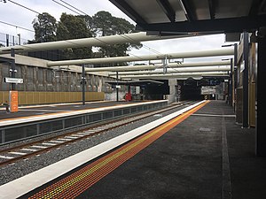
Cheltenham railway station, Melbourne
Railway station in Melbourne, Australia
Distance: Approx. 638 meters
Latitude and longitude: -37.967,145.0547
Cheltenham railway station is a commuter railway station on the Frankston line, which is part of the Melbourne railway network. It serves the south-eastern suburb of Cheltenham, in Melbourne, Victoria, Australia. Cheltenham station is a below ground premium station, featuring three platforms, an island platform with two faces and one side platform.

Beaumaris, Victoria
Suburb of Melbourne, Victoria, Australia
Distance: Approx. 1569 meters
Latitude and longitude: -37.983,145.0434
Beaumaris ( bo-MORR-əs) is a suburb in Melbourne, Victoria, Australia, 20 km south-east of Melbourne's Central Business District, located within the City of Bayside local government area. Beaumaris recorded a population of 13,947 at the 2021 census. Beaumaris is located on Port Phillip Bay and is bounded by Reserve Road and Weatherall Road in the north, Charman Road in the east, the Port Phillip Bay foreshore in the south, and McGregor Avenue, Fifth Street, Keating Street, Iluka Street, Fairleigh Avenue and Royal Melbourne Golf Club in the west.

Westfield Southland
Shopping mall in Victoria, Australia
Distance: Approx. 1280 meters
Latitude and longitude: -37.958,145.05
Westfield Southland (previously known as Southland Centre) is a shopping centre in the suburb of Cheltenham in Melbourne, Australia. Southland has a floor area of 129,180m², making it one of the biggest shopping centres in Australia by size. There are approximately 400 retailers in Southland, including Myer, David Jones and Harris Scarfe.
Royal Melbourne Golf Club
36-hole golf club in Australia
Distance: Approx. 1590 meters
Latitude and longitude: -37.97,145.03
Royal Melbourne Golf Club is a 36-hole golf club in Australia, located in Black Rock, Victoria, a suburb in southeastern Melbourne. Its West and East courses are respectively ranked number 1 and 6 in Australia. The West course is ranked in the top-five courses in the world.
Pennydale, Victoria
Place in Victoria, Australia
Distance: Approx. 1061 meters
Latitude and longitude: -37.96,145.04611111
Pennydale is a neighbourhood in the suburb of Cheltenham in Melbourne, Victoria, Australia, approximately 17 km south-east of the Melbourne central business district. Pennydale lies within Cheltenham between Bay Road to the north, Jack Road to the west, Park Road to the south, and the Frankston railway line to the east. It is entirely within the local government area of the City of Bayside.
1998 Presidents Cup
Golf tournament
Distance: Approx. 1590 meters
Latitude and longitude: -37.97,145.03
The 1998 Presidents Cup was held 11–13 December in Australia at the Royal Melbourne Golf Club in Black Rock, Victoria, a suburb southeast of Melbourne. The International team won the competition by a margin of 201⁄2–111⁄2. This was the first time the International team won the competition, and through 2022, is their sole victory.

Mentone Girls' Secondary College
Public school in Mentone, Victoria, Australia
Distance: Approx. 1370 meters
Latitude and longitude: -37.98083333,145.05388889
Mentone Girls’ Secondary College is a government secondary school for girls located in Melbourne's southeast beachside suburb of Mentone, Victoria. Over 1100 students are enrolled throughout Years 7 to 12, with students transitioning to the college in Year 7 from over 50 primary schools throughout Victoria.
2011 Presidents Cup
Golf match in Australia
Distance: Approx. 1590 meters
Latitude and longitude: -37.97,145.03
The 2011 Presidents Cup was the ninth Presidents Cup, held 17–20 November in Australia at the Royal Melbourne Golf Club in Black Rock, Victoria, a suburb southeast of Melbourne. The United States team won by a score of 19 to 15 over the International team. Jim Furyk won all five of his matches.

Southland railway station
Railway station in Melbourne, Australia
Distance: Approx. 1173 meters
Latitude and longitude: -37.9589,145.0492
Southland railway station is a commuter railway station on the Frankston line, which is part of the Melbourne railway network. It serves the south-eastern suburb of Cheltenham, in Melbourne, Victoria, Australia. Southland station is a ground-level host station, featuring two side platforms.
Victoria Golf Club (Australia)
Distance: Approx. 417 meters
Latitude and longitude: -37.9667,145.0448
The Victoria Golf Club is a golf club in Cheltenham, Victoria, Australia. It is located in the Melbourne Sandbelt, and its course is consistently ranked amongst the best in Australia. It has hosted many events over the years including the Australian Open in 1961, 1981,2002 and 2022 and the Women's Australian Open in 1974, 1976 and 2014.
2013 World Cup of Golf
Golf tournament
Distance: Approx. 1518 meters
Latitude and longitude: -37.9695,145.0308
The 2013 ISPS Handa World Cup of Golf is a golf tournament that was played 21–24 November at Royal Melbourne Golf Club in Melbourne, Australia. It was the 57th World Cup. The format changed from being a team event to being primarily an individual event with a team component.
2019 Presidents Cup
Golf tournament
Distance: Approx. 1590 meters
Latitude and longitude: -37.97,145.03
The 2019 Presidents Cup was the 13th edition of the Presidents Cup golf competition, held at Royal Melbourne Golf Club in Melbourne, Victoria, from 12 to 15 December 2019. Royal Melbourne previously hosted the tournament in 1998, at which the International team had their only victory, and 2011. It is the only international venue to have held the tournament more than once.
Weather in this IP's area
overcast clouds
22 Celsius
23 Celsius
22 Celsius
24 Celsius
1000 hPa
73 %
1000 hPa
998 hPa
10000 meters
2.24 m/s
4.02 m/s
152 degree
100 %