Country:
Region:
City:
Latitude and Longitude:
Time Zone:
Postal Code:
IP information under different IP Channel
ip-api
Country
Region
City
ASN
Time Zone
ISP
Blacklist
Proxy
Latitude
Longitude
Postal
Route
IPinfo
Country
Region
City
ASN
Time Zone
ISP
Blacklist
Proxy
Latitude
Longitude
Postal
Route
MaxMind
Country
Region
City
ASN
Time Zone
ISP
Blacklist
Proxy
Latitude
Longitude
Postal
Route
Luminati
Country
ASN
Time Zone
Asia/Jakarta
ISP
PT Parsaoran Global Datatrans
Latitude
Longitude
Postal
db-ip
Country
Region
City
ASN
Time Zone
ISP
Blacklist
Proxy
Latitude
Longitude
Postal
Route
ipdata
Country
Region
City
ASN
Time Zone
ISP
Blacklist
Proxy
Latitude
Longitude
Postal
Route
Popular places and events near this IP address

Pancoran, South Jakarta
District of South Jakarta
Distance: Approx. 842 meters
Latitude and longitude: -6.2579045,106.82304181
Pancoran is a district (kecamatan) of South Jakarta, one of the five administrative cities that form Jakarta, Indonesia. Pancoran District was originally part of Mampang Prapatan District until it was split off to form its district in 1990. The boundaries of Pancoran District are the Ciliwung River to the east, the Mampang River to the west, and Kapten Tendean Road - Jend.

Mas Tirtodarmo Haryono
Indonesian general (1924–1965)
Distance: Approx. 2333 meters
Latitude and longitude: -6.25722222,106.84611111
Lieutenant General Mas Tirtodarmo Haryono (20 January 1924 – 1 October 1965) was a general officer in the Indonesian Army who was killed during an attempt to kidnap him from his home by members of the 30 September Movement in the early hours of 1 October 1965.

Satriamandala Museum
Military museum in South Jakarta, Indonesia
Distance: Approx. 2315 meters
Latitude and longitude: -6.23143333,106.81873889
The Satriamandala Museum (also spelled Satria Mandala Museum) is the main museum for the Indonesian Armed Forces. Opened on 5 October 1972, it is located on 5.6 hectares (14 acres) of land in South Jakarta and holds numerous artifacts, weapons, and vehicles.
Universitas Siswa Bangsa Internasional
University in Indonesia
Distance: Approx. 2118 meters
Latitude and longitude: -6.247814,106.844884
Universitas Siswa Bangsa Internasional (also known by the acronym USBI), or Sampoerna University, is an international university located in Jakarta, Indonesia. It is the first Indonesian university to offer an accredited U.S. degree entirely within Indonesia.
PTIK Stadium
Football stadium in Indonesia
Distance: Approx. 2233 meters
Latitude and longitude: -6.244878,106.806761
PTIK Stadium is a football stadium in the City of South Jakarta, Indonesia. The stadium has a capacity of 3,000 people. The stadium is owned by the Indonesian National Police.

New Zealand School Jakarta
School in Indonesia
Distance: Approx. 1796 meters
Latitude and longitude: -6.2645,106.8172
The New Zealand School Jakarta (NZSJ), formerly New Zealand Independent School, is an international school located in Kemang, South Jakarta (Jakarta Selatan), Jakarta, Indonesia. It was established in 2002. The school changed its name from New Zealand International School (NZIS) following the ruling by the Government of Indonesia in 2014 that all schools had to remove the word international from their name.
Capital Place Jakarta
Office and hotel in Jakarta, Indonesia
Distance: Approx. 2171 meters
Latitude and longitude: -6.2322961,106.820229
Capital Place Jakarta is a mixed development complex at Jalan Jenderal Gatot Subroto in South Jakarta, Indonesia. Capital Place Office Tower is part of the complex, which also occupies by Four Seasons Hotel. The office tower is a 215.1 meter tall, has 48 floors above & 6 floors below the ground.
Kemang, Jakarta
Place in Jakarta, Indonesia
Distance: Approx. 1239 meters
Latitude and longitude: -6.2608,106.8208
Kemang is a neighborhood in southern part of Jakarta, Indonesia. The area is located mostly in Bangka subdistrict of Mampang Prapatan and partly within Pejaten subdistrict of Pasar Minggu. The main area of Kemang is marked by the roads of Kemang Raya, Prapanca, and Bangka Streets.

Kemang Village
Shopping mall in Jakarta, Indonesia
Distance: Approx. 1864 meters
Latitude and longitude: -6.259418,106.811473
Kemang Village is an integrated development of vertical residences with a shopping mall named Lippo Mall Kemang, hotel, hospital, school, country club, and spa, located at Mampang Prapatan, South Jakarta, Indonesia. The complex has a land area of about 15.5 hectares (38 acres), which is developed by Lippo Group.

Dirgantara Monument
Monument in Jakarta, Indonesia
Distance: Approx. 2122 meters
Latitude and longitude: -6.243085,106.843472
Dirgantara Monument (Indonesian: Monumen Patung Dirgantara), also known as Gatot Kaca Monument after the Javanese wayang figure, is a monument located in Jakarta, Indonesia. It is also known as Tugu Pancoran, after tugu a word for statue and pedestal, and the South Jakarta subdistrict of Pancoran, where it is located. The monument was commissioned by President Sukarno in 1964 as a tribute to the Indonesian Air Force and early Indonesian aviators who flew against the Dutch to achieve independence.

Embassy of Australia, Jakarta
Diplomatic mission
Distance: Approx. 2284 meters
Latitude and longitude: -6.23208333,106.83413889
The Embassy of Australia in Jakarta (Indonesian: Kedutaan Besar Australia di Jakarta) is the diplomatic mission of Australia in Indonesia, located within the Golden Triangle.

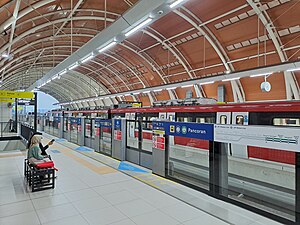
Pancoran Bank BJB LRT Station
LRT station in Indonesia
Distance: Approx. 1693 meters
Latitude and longitude: -6.24212721,106.8384693
Pancoran LRT Station (or Pancoran Bank BJB LRT Station, with Bank BJB granted for naming rights) is a light rail station located in Jalan Gatot Subroto, Pancoran, Pancoran, South Jakarta. The station, which is located at an altitude of +38.510 meters, serves the Cibubur and Bekasi lines of the Jabodebek LRT system.
Weather in this IP's area
few clouds
35 Celsius
38 Celsius
34 Celsius
35 Celsius
1008 hPa
41 %
1008 hPa
1006 hPa
7000 meters
5.14 m/s
270 degree
20 %
05:29:19
17:45:19