Country:
 India
IndiaRegion:
City:
Latitude and Longitude:
Time Zone:
Postal Code:
IP information under different IP Channel
ip-api
Country
Region
City
ASN
Time Zone
ISP
Blacklist
Proxy
Latitude
Longitude
Postal
Route
IPinfo
Country
Region
City
ASN
Time Zone
ISP
Blacklist
Proxy
Latitude
Longitude
Postal
Route
MaxMind
Country
Region
City
ASN
Time Zone
ISP
Blacklist
Proxy
Latitude
Longitude
Postal
Route
Luminati
Country
INASN
Time Zone
Asia/Kolkata
ISP
YOTTA NETWORK SERVICES PRIVATE LIMITED
Latitude
Longitude
Postal
db-ip
Country
Region
City
ASN
Time Zone
ISP
Blacklist
Proxy
Latitude
Longitude
Postal
Route
ipdata
Country
Region
City
ASN
Time Zone
ISP
Blacklist
Proxy
Latitude
Longitude
Postal
Route
Popular places and events near this IP address
Vikaspuri
Neighborhood of Delhi in West Delhi, National Capital Territory of Delhi, India
Distance: Approx. 702 meters
Latitude and longitude: 28.63333333,77.075
Vikaspuri is a posh residential area in West Delhi, India. It is home to a few notable figures.
Tilak Nagar (Delhi)
Neighborhood of Delhi in West Delhi, India
Distance: Approx. 1404 meters
Latitude and longitude: 28.640197,77.089555
Tilak Nagar is a suburban area and commercial hub in the district of West Delhi, Delhi, India.
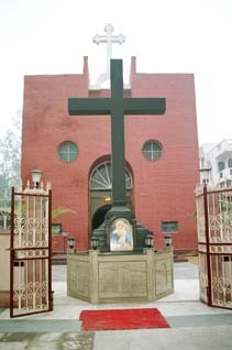
Mar Gregorios Orthodox Church, Janakpuri
Parish church under the Delhi Diocese of the Indian Orthodox Church
Distance: Approx. 1109 meters
Latitude and longitude: 28.6279,77.0922
Mar Gregorios Orthodox Church, Janakpuri is a parish church under the Delhi Diocese of the Indian Orthodox Church. The parish was formed in 1975 for the members of the church residing in West Delhi. The church is the first parish in Diocese of Delhi established in the name of St.
St. Francis De Sales School (New Delhi)
Private, coeducational school in New Delhi, India
Distance: Approx. 645 meters
Latitude and longitude: 28.6243,77.0799
St. Francis de Sales School, also known as Francis de Sales or SFS, is a co-educational private English Medium school in New Delhi, India. Privately funded and independent, it was founded in 1978 by Fr.
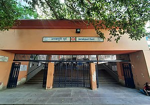
Janakpuri East metro station
Metro station in Delhi, India
Distance: Approx. 633 meters
Latitude and longitude: 28.63301306,77.08659306
The Janakpuri East metro station is located on the Blue Line of the Delhi Metro.

Janakpuri West metro station
Metro station in Delhi, India
Distance: Approx. 289 meters
Latitude and longitude: 28.6295,77.07819444
The Janakpuri West metro station is an interchange station between the Blue Line and Magenta Line of Delhi Metro.
St. Mark's Senior Secondary School, Janakpuri
School in West Delhi, India
Distance: Approx. 1152 meters
Latitude and longitude: 28.619808,77.07907
St. Mark's Senior Secondary School is a secondary school in Janakpuri in West Delhi, India. The school is affiliated to the Central Board of Secondary Education of India, and runs classes from I to XII including a section for children with special needs.
Janakpuri Assembly constituency
Constituency of the Delhi legislative assembly in India
Distance: Approx. 1413 meters
Latitude and longitude: 28.62,77.09
Janakpuri Assembly constituency is one of the 70 Delhi Legislative Assembly constituencies of the National Capital Territory in northern India.
Tilak Nagar Assembly constituency
Constituency of the Delhi legislative assembly in India
Distance: Approx. 1265 meters
Latitude and longitude: 28.639,77.089
Tilak Nagar Assembly constituency is one of the 70 Delhi Legislative Assembly constituencies of the National Capital Territory in northern India.
Vikaspuri Assembly constituency
Constituency of the Delhi legislative assembly in India
Distance: Approx. 1458 meters
Latitude and longitude: 28.641,77.073
Vikaspuri Assembly constituency is one of the 70 Delhi Legislative Assembly constituencies of the National Capital Territory in northern India.
Adarsh Public School
Private school in New Delhi, India
Distance: Approx. 1283 meters
Latitude and longitude: 28.6354,77.0695
Adarsh Public School (APS) is a senior secondary public school located in Vikaspuri in West Delhi, India. The school is affiliated with the Central Board of Secondary Education.
Uttam Nagar
Suburb in West Delhi, National Capital Territory of Delhi, India
Distance: Approx. 702 meters
Latitude and longitude: 28.63333333,77.075
Uttam Nagar is a suburb situated in West Delhi. Uttam Nagar has the Pincode 110059. Uttam Nagar mainly consists of several sub towns that are completely urbanized.
Weather in this IP's area
mist
24 Celsius
25 Celsius
24 Celsius
24 Celsius
1006 hPa
94 %
1006 hPa
982 hPa
2800 meters
3.6 m/s
40 degree
75 %
06:08:40
18:22:20