Country:
Region:
City:
Latitude and Longitude:
Time Zone:
Postal Code:
IP information under different IP Channel
ip-api
Country
Region
City
ASN
Time Zone
ISP
Blacklist
Proxy
Latitude
Longitude
Postal
Route
Luminati
Country
ASN
Time Zone
Australia/Sydney
ISP
Civica Pty Limited
Latitude
Longitude
Postal
IPinfo
Country
Region
City
ASN
Time Zone
ISP
Blacklist
Proxy
Latitude
Longitude
Postal
Route
db-ip
Country
Region
City
ASN
Time Zone
ISP
Blacklist
Proxy
Latitude
Longitude
Postal
Route
ipdata
Country
Region
City
ASN
Time Zone
ISP
Blacklist
Proxy
Latitude
Longitude
Postal
Route
Popular places and events near this IP address

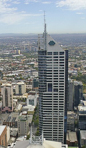
Bourke Place
Skyscraper at 600 Bourke Street, Melbourne central business district, Victoria, Australia
Distance: Approx. 98 meters
Latitude and longitude: -37.81593611,144.95598889
Bourke Place is a 224-metre (735 ft) skyscraper situated at 600 Bourke Street, Melbourne central business district, Victoria, Australia. As of 2024, it is the equal 18th tallest building in Melbourne and the 37th tallest building in Australia. It was completed in 1991.

Supreme Court of Victoria
Superior court of the state of Victoria, Australia
Distance: Approx. 255 meters
Latitude and longitude: -37.81416667,144.95805556
The Supreme Court of Victoria is the highest court in the Australian state of Victoria. Founded in 1852, it is a superior court of common law and equity, with unlimited and inherent jurisdiction within the state. The Supreme Court comprises two divisions: the Trial Division, which oversees its original jurisdiction, and the Court of Appeal, which deals with its appellate jurisdiction, and is frequently referred to as a court in its own right.

140 William Street, Melbourne
Building in Melbourne, Australia
Distance: Approx. 151 meters
Latitude and longitude: -37.8158,144.9586
140 William Street (formerly BHP House) is a 41-storey 152m tall steel, concrete and glass building located in the western end of the central business district of Melbourne, Victoria, Australia. Constructed between 1969 and 1972, BHP House was designed by the architectural practice Yuncken Freeman alongside engineers Irwinconsult, with heavy influence of contemporary skyscrapers in Chicago, Illinois. The local architects sought technical advice from Bangladeshi-American structural engineer Fazlur Rahman Khan, of renowned American architectural firm Skidmore, Owings & Merrill, spending ten weeks at its Chicago office in 1968.
Parks Victoria
Distance: Approx. 81 meters
Latitude and longitude: -37.81594444,144.95780556
Parks Victoria is a government agency of the state of Victoria, Australia. Parks Victoria was established in December 1996 as a statutory authority, reporting to the Victorian Minister for Environment and Climate Change. The Parks Victoria Act 2018 updates the previous act, Parks Victoria Act 1998.

Melbourne Savage Club
Gentlemen's club in Melbourne, Victoria, Australia
Distance: Approx. 302 meters
Latitude and longitude: -37.81659167,144.96041667
Melbourne Savage Club is a private Australian gentlemen's club founded in 1894 and named after the poet, Richard Savage. Bohemian in spirit, the club was to bring together literary men, and those immediately connected or sympathising with literature, the arts, sport or science. Its membership is particularly secretive with a strong code of silence; members are traditionally the elite or 'savages' in the arts, business and politics.
Melbourne City School
School
Distance: Approx. 134 meters
Latitude and longitude: -37.81715,144.95592
Melbourne City School was an independent, co-educational Prep to Year 9 school located in the Melbourne Central Business District on King Street. Melbourne City School was founded in 2010 as an initiative of Eltham College, but closed at the end of 2012 due to low enrolments.

AON Centre (Royal Insurance Building)
Office in Victoria, Australia
Distance: Approx. 283 meters
Latitude and longitude: -37.81722222,144.96
AON Centre (Royal Insurance Group Building) is a commercial office complex located in Melbourne, Victoria, Australia at 430—444 Collins Street, in the heart of the Melbourne CBD. A product of a rigorous design process from Australian architecture firm Yuncken Freeman Architects in 1962, the building undertook a two-year construction period and in 1965 it was first opened revealing a 70 metre high 18-storey structure.

568 Collins Street
Mixed–use skyscraper in Melbourne, Victoria, Australia
Distance: Approx. 268 meters
Latitude and longitude: -37.81836,144.95542
568 Collins Street is a mixed–use skyscraper in Melbourne, Victoria, Australia. The building was first proposed in 2011 and later approved by then-Planning Minister Matthew Guy in early 2012. The skyscraper reaches 224 metres in height– making it one of the tallest buildings in Melbourne.
AMP Square
Office tower in Melbourne, Australia
Distance: Approx. 71 meters
Latitude and longitude: -37.81605556,144.95775
AMP Square is a skyscraper in Melbourne, Australia, located on the corner of Bourke and William streets in the Melbourne central business district. Designed by US firm Skidmore, Owings & Merrill with local firm Bates Smart McCutcheon, and completed in 1969, it was briefly the tallest in the city, and is noted for its use of solid sculpted forms bringing a sense of monumentality to tall buildings.

Netherlands Indies Government Information Service
Distance: Approx. 293 meters
Latitude and longitude: -37.81719444,144.96013889
The Netherlands Indies Government Information Service (NIGIS) was a civil secret service and propaganda organisation based in Australia, during and after World War II. NIGIS was affiliated with the Netherlands East Indies Forces Intelligence Service (NEFIS) and the Netherlands Indies Civil Administration (NICA). Conrad Helfrich, commander of Dutch forces in the Netherlands East Indies, attempted to have NIGIS merged with NEFIS, for which he had responsibility. Helfrich's attempts were resisted by Hubertus van Mook, acting Governor-General of the Dutch East Indies, who wished NIGIS to retain its civil status rather than be absorbed by the military apparatus.

National Bank House
Commercial skyscraper located in Melbourne, Victoria, Australia
Distance: Approx. 206 meters
Latitude and longitude: -37.8151284,144.9588138
National Bank House is a commercial skyscraper located in Melbourne, Victoria, Australia, completed in 1978, designed by architects Godfrey and Spowers. The National Bank of Australia, later the National Australia Bank, made it their headquarters on completion. Located near the crest of the western hill of Bourke Street, the skyscraper was built in the mid-1970s as a speculative office tower, which was fully occupied by the National Bank of Australia as their headquarters.

Supreme Court of Victoria (building)
Court house in Victoria, Australia
Distance: Approx. 266 meters
Latitude and longitude: -37.814085,144.958132
The Supreme Court (Building), is a court building located at 192-228 William Street in Melbourne, Australia. It is part of a complex of buildings which, together with the Supreme Court Library and Court of Appeal, are known as the Melbourne Law Courts. It is currently the home to the Supreme Court of Victoria, the most senior court in the state of Victoria, and inferior only to the High Court of Australia.
Weather in this IP's area
broken clouds
17 Celsius
16 Celsius
15 Celsius
18 Celsius
1019 hPa
57 %
1019 hPa
1014 hPa
10000 meters
7.2 m/s
250 degree
75 %
05:58:00
20:12:56
