Country:
 Bangladesh
Region:
City:
Latitude and Longitude:
Time Zone:
Postal Code:
IP information under different IP Channel
ip-api
Country
Region
City
ASN
Time Zone
ISP
Blacklist
Proxy
Latitude
Longitude
Postal
Route
IPinfo
Country
Region
City
ASN
Time Zone
ISP
Blacklist
Proxy
Latitude
Longitude
Postal
Route
MaxMind
Country
Region
City
ASN
Time Zone
ISP
Blacklist
Proxy
Latitude
Longitude
Postal
Route
Luminati
Country
BDASN
Time Zone
Asia/Dhaka
ISP
Homtech
Latitude
Longitude
Postal
db-ip
Country
Region
City
ASN
Time Zone
ISP
Blacklist
Proxy
Latitude
Longitude
Postal
Route
ipdata
Country
Region
City
ASN
Time Zone
ISP
Blacklist
Proxy
Latitude
Longitude
Postal
Route
Popular places and events near this IP address
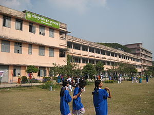
Azimpur Government Girls' School and College
Government school and college in Bangladesh
Distance: Approx. 2039 meters
Latitude and longitude: 23.725,90.387
Azimpur Government Girls' School and College (Bengali: আজিমপুর গভর্নমেন্ট গার্লস স্কুল এন্ড কলেজ) is a secondary and higher secondary school in Azimpur, Dhaka, Bangladesh. It was established in 1957 by the Welfare Association of Government Employees. In 1999 the school had an enrollment of some 2,700 students and a faculty of 82.
Lalbagh Thana
Thana in Dhaka South City Corporation, Bangladesh
Distance: Approx. 1873 meters
Latitude and longitude: 23.71984,90.38974
Lalbagh (Bengali: লালবাগ) is a neighbourhood of the Dhaka District in the division of Dhaka, Bangladesh.
Kamrangirchar Thana
Thana in Dhaka South City Corporation, Bangladesh
Distance: Approx. 1009 meters
Latitude and longitude: 23.71799,90.3678
Kamrangirchar (Bengali: কামরাঙ্গীরচর, lit. 'shoal of Kamrangi') is a thana (police precinct) in Old Dhaka, Bangladesh. The thana is under the jurisdiction of Dhaka South City Corporation wards 55, 56, and 57. Kamrangirchar was a disconnected landmass until 1991.
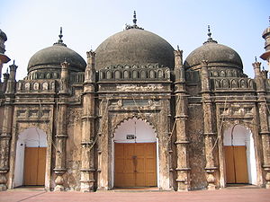
Khan Mohammad Mridha Mosque
Mosque in Dhaka, Bangladesh
Distance: Approx. 1564 meters
Latitude and longitude: 23.7206,90.3853
The Khan Mohammad Mridha Mosque is a historical mosque near Lalbagh Fort in Dhaka, Bangladesh.
West End High School (Dhaka, Bangladesh)
Public school in Dhaka, Bangladesh
Distance: Approx. 1649 meters
Latitude and longitude: 23.7216,90.3854
West End High School is a secondary school situated in Azimpur, Dhaka. It was established in 1920 by the time Dhaka University was established. It was the most western side school of Dhaka city back 1920.
Climate of Dhaka
Distance: Approx. 1228 meters
Latitude and longitude: 23.7,90.375
Dhaka experiences a hot, wet and humid tropical climate. Under the Köppen climate classification, Dhaka has a tropical wet and dry climate. The city has a distinct monsoonal season, with an annual average temperature of 25 °C (77 °F) and monthly means varying between 18 °C (64 °F) in January and 29 °C (84 °F) in August.

Jamia Qurania Arabia Lalbagh
Distance: Approx. 1747 meters
Latitude and longitude: 23.7177,90.3896
Al-Jāmiʿah al-Qurʼāniyyah al-ʿArabiyyah Lālbāgh (Arabic: الجامعة القرآنية العربية لالباغ), better known simply as Lalbagh Madrasah (Bengali: লালবাগ মাদ্রাসা), is a Qawmi madrasa providing higher Islamic studies in Dhaka, Bangladesh. It has seven education sections from kindergarten to post-graduate levels.
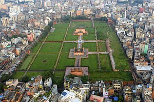
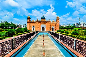
Lalbagh Fort
Historical site in Dhaka, Bangladesh
Distance: Approx. 1682 meters
Latitude and longitude: 23.719,90.3881
Lalbagh anda (Bengali: লালবাগ কেল্লা, romanized: Lālabāga Kēllā) is a fort in the old city of Dhaka, Bangladesh. Its name is derived from its neighborhood Lalbagh, which means Red Garden. The term Lalbagh refers to reddish and pinkish architecture from the Mughal period.
New Paltan
Distance: Approx. 2047 meters
Latitude and longitude: 23.7284,90.3806
New Paltan (Azimpur Natun Paltan in Dhaka City Corporation records) is near Dhaka's New Market in Azimpur. Several markets and a number of educational institutions (Dhaka University's Institute of Social Welfare and Research and arts faculty, Dhaka College, Government Laboratory High School, Dhaka City College and Eden Mohila College) are nearby. Border Guards Bangladesh headquarters is in neighbouring Pilkhana.

Salimullah Orphanage
Historic orphanage in Bangladesh
Distance: Approx. 1879 meters
Latitude and longitude: 23.7225,90.3876
Salimullah Orphanage also known as Sir Salimullah Muslim Orphanage is a historic orphanage in Bangladesh founded by and named after Nawab Bahadur Sir Khwaja Salimullah.

Dhaka-7
Constituency of Bangladesh's Jatiya Sangsad
Distance: Approx. 1905 meters
Latitude and longitude: 23.72,90.39
Dhaka-7 is a constituency represented in the Jatiya Sangsad (National Parliament) of Bangladesh.

Azimpur Dayera Sharif Khanqah
Historic site in Azimpur, Dhaka
Distance: Approx. 1785 meters
Latitude and longitude: 23.72497222,90.38269444
The historical shrine of Dayera Sharif Khanqah, commonly known as Bara Dayera Sharif, is situated in the Azimpur locality of Dhaka. The Persian word Dayera means "circle" or "work area". As a rule, the heirs of the Dayera Sharif never go outside the area, except for pilgrimage.
Weather in this IP's area
haze
31 Celsius
37 Celsius
31 Celsius
31 Celsius
1008 hPa
66 %
1008 hPa
1007 hPa
4000 meters
1.54 m/s
260 degree
75 %
05:57:26
17:29:08