Country:
 Hong Kong (China)
Region:
City:
Latitude and Longitude:
Time Zone:
Postal Code:
IP information under different IP Channel
ip-api
Country
Region
City
ASN
Time Zone
ISP
Blacklist
Proxy
Latitude
Longitude
Postal
Route
IPinfo
Country
Region
City
ASN
Time Zone
ISP
Blacklist
Proxy
Latitude
Longitude
Postal
Route
MaxMind
Country
Region
City
ASN
Time Zone
ISP
Blacklist
Proxy
Latitude
Longitude
Postal
Route
Luminati
Country
HKASN
Time Zone
Asia/Hong_Kong
ISP
AOFEI DATA INTERNATIONAL COMPANY LIMITED
Latitude
Longitude
Postal
db-ip
Country
Region
City
ASN
Time Zone
ISP
Blacklist
Proxy
Latitude
Longitude
Postal
Route
ipdata
Country
Region
City
ASN
Time Zone
ISP
Blacklist
Proxy
Latitude
Longitude
Postal
Route
Popular places and events near this IP address

True Light Girls' College
Girls' secondary school in Hong Kong
Distance: Approx. 258 meters
Latitude and longitude: 22.3138,114.1728
True Light Girls' College (TLGC, Chinese: 真光女書院) is a Christian girls' secondary school in Kowloon, Hong Kong. It was founded in 1973, to commemorate the centenary of the first True Light Middle School, which was founded in 1872 in Canton by the American missionary, Harriet Newell Noyes. It is run by the Kowloon True Light Middle School Management Board with the assistance of the Hong Kong Council of the Church of Christ in China.

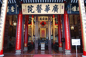
Kwong Wah Hospital
Hospital in Kowloon, Hong Kong
Distance: Approx. 113 meters
Latitude and longitude: 22.315,114.1722
Kwong Wah Hospital is a 1,141-bed Charitable hospital in Yau Ma Tei, Hong Kong. Located on 25 Waterloo Road, Kwong Wah Hospital is the main district general hospital was founded by the Tung Wah Group in 1911, and managed by the Hospital Authority since 1991. It provides a full range of medical services to the population of West Kowloon and Wong Tai Sin.

Ho King Commercial Building
Distance: Approx. 21 meters
Latitude and longitude: 22.31585,114.17188
Ho King Commercial Building (Chinese: 好景商業中心; Jyutping: hou2 ging2 soeng1 jip6 zung1 sam1) and Ho King Shopping Centre (Chinese: 好景商場; Jyutping: hou2 ging2 soeng1 coeng4) are located at the junction of Fa Yuen Street and Dundas Street in Mong Kok, Hong Kong. Built in the 1980s, the lower levels of the shopping centre mainly sold video games and video game consoles in the early days. Gangsters later came in and began selling pornographic and unlicensed copies of VCDs that have made the shopping centre famous.

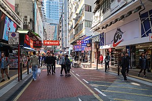
Fa Yuen Street
Distance: Approx. 200 meters
Latitude and longitude: 22.31773,114.17148
Fa Yuen Street (traditional Chinese: 花園街; simplified Chinese: 花园街; pinyin: Huāyuán Jiē; Cantonese Yale: fa1 yun4 gaai1) is a street between Boundary Street and Dundas Street in Mong Kok, Kowloon, Hong Kong. With over fifty stores selling sport shoes, the street is famous for selling sport gear and is known as Sport Shoes Street or Sneaker Street (波鞋街). Fa Yuen (花園) means "garden" in Cantonese.

Shantung Street
Distance: Approx. 270 meters
Latitude and longitude: 22.31764,114.17007
Shantung Street (Chinese: 山東街) is a street in Mong Kok, Kowloon in Hong Kong. It spans from Ferry Street in the west to Yim Po Fong Street in the east.

Macpherson Stadium, Hong Kong
Indoor stadium in Hong Kong
Distance: Approx. 223 meters
Latitude and longitude: 22.318,114.1721
MacPherson Stadium (Chinese: 麥花臣室內體育館) is an indoor stadium that plays an important role to the development of youth recreation in Hong Kong. Located at Yim Po Fong Street, on the edge of Mong Kok, a high population density area, it has a capacity of 1,850. The stadium is within Queen Elizabeth II Youth Centre (伊利沙伯女皇二世青年遊樂場館).

Mong Kok Computer Centre
Shopping mall for computers in Kowloon
Distance: Approx. 297 meters
Latitude and longitude: 22.3185,114.171
Mong Kok Computer Centre (Chinese: 旺角電腦中心; Jyutping: mong6 gok3 din6 nou5 zung1 sam1) is a shopping mall for computers and computer related products in Nelson Street, in Mong Kok, Hong Kong. The three floor mall houses more than 70 computer shops and attracts some 10,000 customers daily. Shops sell various kinds of products, including laptops, computer software, hardware and other accessories.
Tung Wah Museum
Distance: Approx. 123 meters
Latitude and longitude: 22.3149,114.1719
Tung Wah Museum is a museum housed in the former Main Hall Building of Kwong Wah Hospital, located at 25 Waterloo Road, Kowloon, Hong Kong. Only this building was preserved when Kwong Wah Hospital was re-developed in 1958–1963. This building was built in 1911; it was classified as a Grade I historic building and in 2010, it was declared as a monument in 2010.
Hong Kong College of Engineering
Distance: Approx. 296 meters
Latitude and longitude: 22.31747,114.1696
The Hong Kong College of Engineering (HKCE) was established in 1992 and is a new conceptual college that focuses on providing training for the engineering industry. It provides, by both local and distance learning, programmes leading to the award of a Professional Certificate, Diploma, Bachelor degree, Master's degree and ultimately Chartered Engineer. The college's core programmes include: Building Services Engineering, Facilities Management, Civil Engineering, Construction Management, Mechanical Engineering, Electrical and Electronic Engineering and Data Center.

King Wah Centre
Shopping centre in Mong Kok, Hong Kong
Distance: Approx. 301 meters
Latitude and longitude: 22.31788,114.169903
The King Wah Centre (Chinese: 瓊華中心; Jyutping: king4 faa1 zung1 sam1), situated at the northeast corner of Shantung Street and Nathan Road, is a popular shopping centre in the Mong Kok area of Hong Kong. The 16-storey building features ten restaurant floors, three karaoke floors, along with 136 stores selling a variety of fashionable products.
Nelson Street
Street in Mong Kok, Kowloon, Hong Kong
Distance: Approx. 309 meters
Latitude and longitude: 22.31877778,114.17196667
Nelson Street (Chinese: 奶路臣街) is a street in Mong Kok, Kowloon, Hong Kong, China. The street is 240 metres in length and runs in the east–west direction. It can be accessed from exits E1 and E2 of the Mong Kok station.
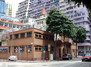
All Saints' Cathedral, Hong Kong
Cathedral of the Diocese of Western Kowloon of the Hong Kong Anglican Church
Distance: Approx. 212 meters
Latitude and longitude: 22.3174,114.1734
All Saints' Cathedral (Chinese: 諸聖座堂) is an Anglican (Episcopal) church at 11 Pak Po Street and 2 Yim Po Fong Street (KIL no. 2625), in Mong Kok, Kowloon, Hong Kong. It was founded in Yau Ma Tei in 1891 on All Saints' Day.
Weather in this IP's area
overcast clouds
29 Celsius
35 Celsius
28 Celsius
29 Celsius
1005 hPa
82 %
1005 hPa
1001 hPa
10000 meters
1.34 m/s
50 degree
100 %
06:10:42
18:25:09