Country:
 Indonesia
Region:
City:
Latitude and Longitude:
Time Zone:
Postal Code:
IP information under different IP Channel
ip-api
Country
Region
City
ASN
Time Zone
ISP
Blacklist
Proxy
Latitude
Longitude
Postal
Route
IPinfo
Country
Region
City
ASN
Time Zone
ISP
Blacklist
Proxy
Latitude
Longitude
Postal
Route
MaxMind
Country
Region
City
ASN
Time Zone
ISP
Blacklist
Proxy
Latitude
Longitude
Postal
Route
Luminati
Country
IDASN
Time Zone
Asia/Jakarta
ISP
PT Parsaoran Global Datatrans
Latitude
Longitude
Postal
db-ip
Country
Region
City
ASN
Time Zone
ISP
Blacklist
Proxy
Latitude
Longitude
Postal
Route
ipdata
Country
Region
City
ASN
Time Zone
ISP
Blacklist
Proxy
Latitude
Longitude
Postal
Route
Popular places and events near this IP address

Taman Mini Indonesia Indah
Theme park in Jakarta, Indonesia
Distance: Approx. 2450 meters
Latitude and longitude: -6.30166667,106.89666667
Taman Mini Indonesia Indah (lit. 'Beautiful Indonesia Mini Park'; formerly Taman Mini "Indonesia Indah" with apostrophes—abbreviated as TMII) is a culture-based recreational area located in East Jakarta, Indonesia. Since July 2021, it is operated by PT Taman Wisata Candi Borobudur, Prambanan, dan Ratu Boko, a subsidiary of the state-owned tourism holding company Injourney. It was operated by Yayasan Harapan Kita, a foundation established by Siti Hartinah, the first lady during most of the New Order and wife of Suharto, and run by Suharto's descendants since his death until 2021.
Cipayung
District in Jakarta, Indonesia
Distance: Approx. 2214 meters
Latitude and longitude: -6.31666667,106.9
Cipayung is a district (kecamatan) of East Jakarta, Indonesia, situated in the southeastern part of Jakarta, in the outskirts of Jakarta. Its northern boundary is Pondok Gede Raya Road, its eastern boundary is Sunter River to the East, and its western boundary is Jagorawi Tollway. Marshes can still be found in Cipayung.

Ciracas
District in DKI Jakarta, Indonesia
Distance: Approx. 1323 meters
Latitude and longitude: -6.32694444,106.875
Ciracas is a district (kecamatan) of East Jakarta, one of the five administrative cities of Jakarta, Indonesia. Ciracas is the southernmost district in Jakarta. The area of Cibubur Scout's camping ground complex is located partly within the Ciracas District, although the main camping ground area is located in Cipayung District.
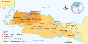
Tarumanagara
Former kingdom in Indonesia
Distance: Approx. 2925 meters
Latitude and longitude: -6.33333333,106.9
Tarumanagara or Taruma Kingdom or just Taruma was an early Sundanese Indianised kingdom, located in western Java, whose 5th-century ruler, Purnawarman, produced the earliest known inscriptions in Java, which are estimated to date from around 358 CE. At least seven stone inscriptions connected to this kingdom were discovered in Western Java area, near Bogor and Jakarta.
Jakarta Indonesia Korean School
Korean international school in Indonesia
Distance: Approx. 1491 meters
Latitude and longitude: -6.3174321,106.8934126
Jakarta Indonesia Korean School (JIKS, Korean: 자카르타한국국제학교), formerly Jakarta International Korean School, is a South Korean international school in East Jakarta, Indonesia. As of 2005 it is the largest overseas South Korean school, with 1,450 students. As of 2009 the school's student body is twice as large as that of the Korean International School, HCMC in Ho Chi Minh City, the next-largest South Korean international school.

Indonesia Museum
Ethnography and anthropology museum in Jakarta, Indonesia
Distance: Approx. 2095 meters
Latitude and longitude: -6.30111111,106.89138889
The Indonesia Museum (Indonesian: Museum Indonesia), is an anthropology and ethnological museum located in Taman Mini Indonesia Indah (TMII), Jakarta, Indonesia. The museum is concentrated on arts and cultures of various ethnic groups that inhabit Indonesian archipelago and formed the modern nation of Indonesia. The museum is a richly decorated building in Balinese architecture.
GOR Ciracas Stadium
Distance: Approx. 1884 meters
Latitude and longitude: -6.3252357,106.8656374
GOR Ciracas Stadium is a multi-purpose stadium in the city of East Jakarta, Indonesia. The stadium has a capacity of 5,000 people. It is the former home base of Villa 2000 After changed its name to Celebest FC in 2016 and moved to its current stadium in Gawalise Stadium in the same year.

Indonesian Hakka Museum
Museum in East Jakarta, Jakarta, Indonesia
Distance: Approx. 2913 meters
Latitude and longitude: -6.30538889,106.904
The Indonesian Hakka Museum (Indonesian: Museum Hakka Indonesia) is a museum about Hakka people in Taman Mini Indonesia Indah, East Jakarta, Jakarta, Indonesia.

Komodo Indonesian Fauna Museum and Reptile Park
Museum in Indonesia
Distance: Approx. 2693 meters
Latitude and longitude: -6.30394731,106.901011
Komodo Indonesian Fauna Museum and Reptile Park (Indonesian: Museum Fauna Indonesia Komodo dan Taman Reptilia), is a zoological museum located within the Taman Mini Indonesia Indah (TMII) compound, in East Jakarta, Indonesia. The museum specialized on presenting various collection of the fauna of Indonesia, especially endemic animals of Indonesia, to provides information and education on Indonesian animal diversity. The Komodo Fauna Museum is located on southeast corner of Taman Mini Indonesia Indah cultural park.

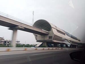
TMII LRT Station
LRT station in Indonesia
Distance: Approx. 2592 meters
Latitude and longitude: -6.292874,106.880535
TMII LRT Station, often referred to as Taman Mini LRT Station is a light rail station located in Jalan Mabes Hankam, Pinang Ranti, Makasar, East Jakarta. The station serves the Cibubur line of the Jabodebek LRT system. The name is derived from Taman Mini Indonesia Indah Theme Park located near the station, although access between is connected by Travoy Hub.

Kampung Rambutan LRT Station
LRT station in Indonesia
Distance: Approx. 878 meters
Latitude and longitude: -6.309541,106.884325
Kampung Rambutan LRT Station is a light rail station located in Jalan Bungur, Rambutan, Ciracas, East Jakarta. The station serves the Cibubur line of the Jabodebek LRT system. The station is located inside the Kampung Rambutan Bus Terminal itself, hence the station name.
Ciracas LRT Station
LRT station in Indonesia
Distance: Approx. 1121 meters
Latitude and longitude: -6.3237,106.8867
Ciracas LRT Station is a light rail station located in Jalan Cikago, Ciracas, Ciracas, East Jakarta. The station serves the Cibubur line of the Jabodebek LRT system.
Weather in this IP's area
scattered clouds
29 Celsius
32 Celsius
29 Celsius
32 Celsius
1014 hPa
61 %
1014 hPa
1009 hPa
6000 meters
3.09 m/s
240 degree
38 %
05:29:03
17:45:09