103.144.249.104 - IP Lookup: Free IP Address Lookup, Postal Code Lookup, IP Location Lookup, IP ASN, Public IP
Country:
Region:
City:
Location:
Time Zone:
Postal Code:
ISP:
ASN:
language:
User-Agent:
Proxy IP:
Blacklist:
IP information under different IP Channel
ip-api
Country
Region
City
ASN
Time Zone
ISP
Blacklist
Proxy
Latitude
Longitude
Postal
Route
db-ip
Country
Region
City
ASN
Time Zone
ISP
Blacklist
Proxy
Latitude
Longitude
Postal
Route
IPinfo
Country
Region
City
ASN
Time Zone
ISP
Blacklist
Proxy
Latitude
Longitude
Postal
Route
IP2Location
103.144.249.104Country
Region
nagano
City
nagano
Time Zone
Asia/Tokyo
ISP
Language
User-Agent
Latitude
Longitude
Postal
ipdata
Country
Region
City
ASN
Time Zone
ISP
Blacklist
Proxy
Latitude
Longitude
Postal
Route
Popular places and events near this IP address

Battles of Kawanakajima
Clan conflicts in feudal Japan from 1553 to 1564
Distance: Approx. 2015 meters
Latitude and longitude: 36.648611,138.194722
The Battles of Kawanakajima (川中島の戦い, Kawanakajima no tatakai) were a series of battles fought in the Sengoku period of Japan between Takeda Shingen of Kai Province and Uesugi Kenshin of Echigo Province from 1553 to 1564. Shingen and Kenshin contested each other for control of the plain of Kawanakajima between the Sai River and Chikuma River in northern Shinano Province, located in the present-day city of Nagano. The battles were triggered after Shingen conquered Shinano, expelling Ogasawara Nagatoki and Murakami Yoshikiyo, who subsequently turned to Kenshin for help.

Zenkō-ji
Buddhist temple in Nagano, Japan
Distance: Approx. 3216 meters
Latitude and longitude: 36.66166667,138.18777778
Zenkō-ji (善光寺, Temple of the Benevolent Light) is a Buddhist temple located in the city of Nagano, Japan. The temple was built in the 7th century. The modern city of Nagano began as a town built around the temple.

Big Hat
Sports venue in Nagano, Japan
Distance: Approx. 1178 meters
Latitude and longitude: 36.62972222,138.19583333
The Big Hat (ビッグハット, Biggu Hatto) is an indoor ice hockey arena in Nagano, Japan with a capacity of 10,104 seated spectators. Its official name is the Nagano Wakasato Tamokuteki Sports Arena. The arena was completed and officially opened on December 10, 1995.

White Ring (arena)
Distance: Approx. 3764 meters
Latitude and longitude: 36.60472222,138.20638889
The White Ring, officially Nagano City Mashima General Sports Arena, is an indoor sporting arena located in Nagano, Japan. The capacity of the arena is 7,000 people. It was a venue at the 1998 Winter Olympics, hosting the figure skating and short track speed skating events.
Nagano (city)
Core city in Chūbu, Japan
Distance: Approx. 2015 meters
Latitude and longitude: 36.64861111,138.19472222
Nagano (長野市, Nagano-shi, pronounced [naganoꜜ ɕi]) is the capital and largest city of Nagano Prefecture, located in the Nagano Basin (Zenkoji Daira) in the central Chūbu region of Japan. Nagano is categorized as a core city of Japan. Nagano City is the highest prefectural capital in Japan, with an altitude of 371.4 meters (1,219 ft).

Austria at the 1998 Winter Olympics
Sporting event delegation
Distance: Approx. 2664 meters
Latitude and longitude: 36.65586,138.192131
Austria competed at the 1998 Winter Olympics in Nagano, Japan.

Horikirizawa Dam
Dam in Nagano Prefecture, Japan
Distance: Approx. 3637 meters
Latitude and longitude: 36.66472222,138.19305556
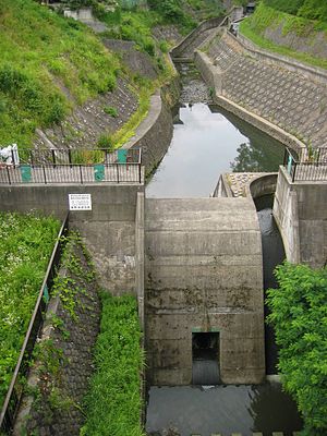
Horikirizawa Dam (Japanese: 堀切沢雨水調整ダム) is a dam in Nagano Prefecture, Japan.

University of Nagano
University in Nagano, Nagano Prefecture, Japan
Distance: Approx. 3938 meters
Latitude and longitude: 36.66555556,138.20055556
The University of Nagano (長野県立大学, Nagano Kenritsu Daigaku), abbreviated as Kendai (県大), is a co-educational 4-year public university located in Nagano, Nagano, Japan. It is the newest of the ten major universities in Nagano Prefecture. The University of Nagano consists of two campuses, named for their locations, Miwa Campus and Gocho Campus, respectively.

Nagano Prefectural Shinano Art Museum
Art museum in Nagano, Japan
Distance: Approx. 3254 meters
Latitude and longitude: 36.661566,138.191039
Nagano Prefectural Shinano Art Museum (長野県信濃美術館, Nagano-ken Shinano Bijutsukan) opened as Shinano Art Museum in Jōyama Park (城山公園), Nagano, Nagano Prefecture, Japan in 1966, becoming a prefectural museum three years later. It is dedicated to the artists of, and works relating to, Shinshū, including paintings by Hishida Shunsō, Nakamura Fusetsu, and Fujishima Takeji. On 26 April 1990, the Higashiyama Kaii Gallery (東山魁夷館) opened as an annex; currently, there are more than 970 works by the artist.

Hachijuni Bank
Regional bank in Japan
Distance: Approx. 1231 meters
Latitude and longitude: 36.64405556,138.18319444
Hachijuni Bank (Japanese: 八十二銀行) is a Japanese regional bank with its head office in Nagano City, Nagano Prefecture, Japan. Its name means the 82nd Bank, as it was established in 1931 as the merger of 19th NationalBank, established in 1877 in Ueda, Nagano, and 63th National Bank, established in 1888 in Matsushiro, Nagano, reflecting the good banker's arithmetic sense of 19 plus 63 equals 82. The bank moved its head office to the current address of Nakagosho Okda-machi (中御所岡田町, 36°38′38.6″N 138°10′59.5″E), Nagano City, in 1969.

Nagano Prefectural Art Museum
Distance: Approx. 3252 meters
Latitude and longitude: 36.6616,138.1907
Nagano Prefectural Art Museum (長野県立美術館, Nagano Kenritsu Bijutsukan) is a museum in Nagano, Nagano Prefecture, Japan. It is one of Japan's many museums which are supported by a prefecture.

Nagano Holy Saviour Church
Church in Nagano, Japan
Distance: Approx. 2594 meters
Latitude and longitude: 36.65627778,138.18208333
Nagano Holy Saviour Church is the Christian church located in Nagano, Nagano, Japan, which belongs to the Diocese of Chubu of the Anglican Church in Japan. The church building is a registered Tangible Cultural Property of Japan.
Weather in this IP's area
overcast clouds
3 Celsius
3 Celsius
3 Celsius
3 Celsius
1026 hPa
91 %
1026 hPa
945 hPa
1616 meters
0.88 m/s
1.06 m/s
52 degree
100 %
