103.142.98.179 - IP Lookup: Free IP Address Lookup, Postal Code Lookup, IP Location Lookup, IP ASN, Public IP
Country:
 Solomon Islands
Region:
City:
Location:
Time Zone:
Postal Code:
ISP:
ASN:
language:
User-Agent:
Proxy IP:
Blacklist:
IP information under different IP Channel
ip-api
Country
Region
City
ASN
Time Zone
ISP
Blacklist
Proxy
Latitude
Longitude
Postal
Route
db-ip
Country
Region
City
ASN
Time Zone
ISP
Blacklist
Proxy
Latitude
Longitude
Postal
Route
IPinfo
Country
Region
City
ASN
Time Zone
ISP
Blacklist
Proxy
Latitude
Longitude
Postal
Route
IP2Location
103.142.98.179Country
sbRegion
guadalcanal
City
honiara
Time Zone
Pacific/Guadalcanal
ISP
Language
User-Agent
Latitude
Longitude
Postal
ipdata
Country
Region
City
ASN
Time Zone
ISP
Blacklist
Proxy
Latitude
Longitude
Postal
Route
Popular places and events near this IP address

British Solomon Islands
1893–1978 British protectorate in Oceania
Distance: Approx. 241 meters
Latitude and longitude: -9.43509167,159.95123889
The British Solomon Islands Protectorate was first established in June 1893, when Captain Herbert Gibson of HMS Curacoa declared the southern Solomon Islands a British protectorate. Christian missionaries began visiting the Solomons from the 1840s, beginning with an attempt by French Catholics under Jean-Baptiste Epalle to establish a mission on Santa Isabel Island, which was abandoned after Epalle was killed by islanders in 1845. Anglican missionaries began arriving from the 1850s, followed by other denominations, over time gaining a large number of converts.
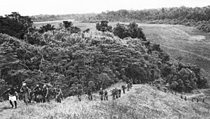
Carlson's patrol
WWII anti-Japanese operation in 1942
Distance: Approx. 241 meters
Latitude and longitude: -9.43509167,159.95123889
Carlson's patrol, also known as The Long Patrol or Carlson's long patrol, was an operation by the 2nd Marine Raider Battalion under the command of Evans Carlson during the Guadalcanal campaign against the Imperial Japanese Army from 6 November to 4 December 1942. In the operation, the 2nd Raiders attacked forces under the command of Toshinari Shōji, which were escaping from an attempted encirclement in the Koli Point area on Guadalcanal and attempting to rejoin other Japanese army units on the opposite side of the U.S. Lunga perimeter. In a series of small unit engagements over 29 days, the 2nd Raiders killed almost 500 Japanese soldiers while suffering 16 killed, although many were afflicted by disease.

Matanikau Offensive
1942 World War II battle on the Solomon Islands
Distance: Approx. 241 meters
Latitude and longitude: -9.43509167,159.95123889
The Matanikau Offensive, from 1–4 November 1942, sometimes referred to as the Fourth Battle of the Matanikau, was an engagement between United States (U.S.) Marine and Army and Imperial Japanese Army forces around the Matanikau River and Point Cruz area on Guadalcanal during the Guadalcanal campaign of World War II. The action was one of the last of a series of engagements between U.S. and Japanese forces near the Matanikau River during the campaign. In the engagement, seven battalions of U.S. Marine and Army troops under the overall command of Alexander Vandegrift and tactical command of Merritt A. Edson, following up on the U.S. victory in the Battle for Henderson Field, crossed the Matanikau River and attacked Japanese Army units between the river and Point Cruz, on the northern Guadalcanal coast. The area was defended by the Japanese Army's 4th Infantry Regiment under Nomasu Nakaguma along with various other support troops, under the overall command of Harukichi Hyakutake.

Point Cruz
Suburb in Guadalcanal, Honiara Town, Solomon Islands
Distance: Approx. 4 meters
Latitude and longitude: -9.43333333,159.95
Point Cruz is a peninsula in the center of Honiara, on Guadalcanal Island. Honiara is the capital city of the Solomon Islands. Point Cruz is located on the Tandai Highway, and is ¼ mile north of the Solomon Islands Parliament Building.

Honiara Solomon Islands College of Higher Education
University in Honiara, Solomon Islands
Distance: Approx. 241 meters
Latitude and longitude: -9.43509167,159.95123889
Honiara Solomon Islands College of Higher Education (SICHE) is a university in Honiara, Solomon Islands; apart from the University of the South Pacific, which has a satellite campus in the country. It is located in eastern Honiara, south of Honiara Golf Club, just to the southwest of King George VI National High School.
Woodford International School
Private school in Honiara, Solomon Islands
Distance: Approx. 241 meters
Latitude and longitude: -9.43509167,159.95123889
Woodford International School, also called the International School, is a school in Honiara, Solomon Islands; apart from the Honiara Solomon Islands College of Higher Education (SICHE), a university in Honiara; and the University of the South Pacific (USP) Solomon Islands Campus. The school is located just to the northwest of the Solomon Islands College of Higher Education.

University of the South Pacific Solomon Islands
Distance: Approx. 241 meters
Latitude and longitude: -9.43509167,159.95123889
The University of the South Pacific (USP) Solomon Islands Campus is a satellite campus of the University of the South Pacific, based in Honiara, Solomon Islands; apart from the Honiara Solomon Islands College of Higher Education (SICHE) a university in Honiara; and the Woodford International School. The University of the South Pacific campus is located near Chinatown, about 75 metres (246 ft) to the southwest of Lawson Tama Stadium. It offers continuing and community education courses to the South Pacific member countries.
Town Ground, Honiara
Suburb in Guadalcanal, Honiara Town, Solomon Islands
Distance: Approx. 4 meters
Latitude and longitude: -9.43333333,159.95
Town Ground is a suburb in Honiara, Solomon Islands, located in the main center on the Tandai Highway. Town Ground is in the Honiara City Council ward of Nggosi and Rove-Lengakiki. Town Ground is East of Rove and West of Point Cruz.
Skyline, Honiara
Suburb in Guadalcanal, Honiara Town, Solomon Islands
Distance: Approx. 4 meters
Latitude and longitude: -9.43333333,159.95
Skyline is a suburb of Honiara, Solomon Islands, directly south of the town center.

Vuhokesa
Suburb in Guadalcanal, Honiara Town, Solomon Islands
Distance: Approx. 4 meters
Latitude and longitude: -9.43333333,159.95
Vuhokesa is a suburb in Honiara located in the main center on the Tandai Highway and includes the City Council roundabout. Vuhokesa is in the Honiara City Council ward of Vavaea. and is East of Point Cruz and West of Lord Howe Settlement.
Vavaea, Honiara
Ward in Solomon Islands
Distance: Approx. 4 meters
Latitude and longitude: -9.43333333,159.95
Vavaea is a suburb of Honiara, Solomon Islands.
Solomon Islands National University
University of Solomon islands
Distance: Approx. 231 meters
Latitude and longitude: -9.435,159.9512
The Solomon Islands National University (SINU) was established in 2013 by the Government of the Solomon Islands.
Weather in this IP's area
overcast clouds
26 Celsius
27 Celsius
26 Celsius
26 Celsius
1008 hPa
86 %
1008 hPa
979 hPa
10000 meters
0.68 m/s
1.5 m/s
71 degree
99 %