103.142.13.16 - IP Lookup: Free IP Address Lookup, Postal Code Lookup, IP Location Lookup, IP ASN, Public IP
Country:
Region:
City:
Location:
Time Zone:
Postal Code:
IP information under different IP Channel
ip-api
Country
Region
City
ASN
Time Zone
ISP
Blacklist
Proxy
Latitude
Longitude
Postal
Route
Luminati
Country
ASN
Time Zone
Asia/Tokyo
ISP
Asahikawa Cable Television Co., Ltd.
Latitude
Longitude
Postal
IPinfo
Country
Region
City
ASN
Time Zone
ISP
Blacklist
Proxy
Latitude
Longitude
Postal
Route
IP2Location
103.142.13.16Country
Region
hokkaido
City
asahikawa
Time Zone
Asia/Tokyo
ISP
Language
User-Agent
Latitude
Longitude
Postal
db-ip
Country
Region
City
ASN
Time Zone
ISP
Blacklist
Proxy
Latitude
Longitude
Postal
Route
ipdata
Country
Region
City
ASN
Time Zone
ISP
Blacklist
Proxy
Latitude
Longitude
Postal
Route
Popular places and events near this IP address

Asahikawa
Core city in Hokkaido, Japan
Distance: Approx. 46 meters
Latitude and longitude: 43.76666667,142.36666667
Asahikawa (旭川市, Asahikawa-shi) is a city in Kamikawa Subprefecture, Hokkaido, Japan. It is the capital of the subprefecture, and the second-largest city in Hokkaido, after Sapporo. It has been a core city since April 1, 2000.

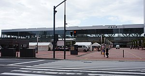
Asahikawa Station
Railway station in Asahikawa, Hokkaido, Japan
Distance: Approx. 782 meters
Latitude and longitude: 43.763005,142.358995
Asahikawa Station (旭川駅, Asahikawa-eki) is a railway station in Asahikawa, Hokkaido, Japan, operated by the Hokkaido Railway Company (JR Hokkaido). Asahikawa Station is the central train station for the city of Asahikawa, which is the second largest city in Hokkaido by population after Sapporo.

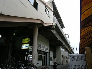
Asahikawa-Yojō Station
Railway station in Asahikawa, Hokkaido, Japan
Distance: Approx. 788 meters
Latitude and longitude: 43.76406,142.37592
Asahikawa-Yojō Station (旭川四条駅, Asahikawa-Yojō eki) is a railway station located in 4-Jōdōri 18-chōme, Asahikawa, Hokkaidō, on the Sōya Main Line, and is operated by the Hokkaido Railway Company (JR Hokkaidō).

Shin-Asahikawa Station
Railway station in Asahikawa, Hokkaido, Japan
Distance: Approx. 2056 meters
Latitude and longitude: 43.78026389,142.3847944
Shin-Asahikawa Station (新旭川駅, Shin-Asahikawa eki) is a railway station located in Asahikawa, Hokkaido, Japan, operated by the Hokkaido Railway Company (JR Hokkaido).
Kaguraoka Station
Railway station in Asahikawa, Hokkaido, Japan
Distance: Approx. 2561 meters
Latitude and longitude: 43.74486111,142.35836111
Kaguraoka Station (神楽岡駅, Kaguraoka-eki) is a train station located in Asahikawa, Hokkaidō, Japan. It is operated by the Hokkaido Railway Company. Only local trains stop.

Bombing of the Fusetsu no Gunzo and Institute of Northern Cultures
Distance: Approx. 1201 meters
Latitude and longitude: 43.774536,142.356302
The Bombing of the Fusetsu no Gunzo and Institute of Northern Cultures (風雪の群像・北方文化研究施設爆破事件, Fūsetsu no Gunzō Hoppō Bunka Kenkyū Shisetsu Bakuha Jiken) was a terrorist bombing that occurred on 23 October 1972. It was undertaken by a group which would soon be known as the East Asia Anti-Japan Armed Front, though this name was not decided on until later in the same year.

Hokkaido Asahikawa Kita High School
School
Distance: Approx. 2539 meters
Latitude and longitude: 43.7897,142.3701
Hokkaido Asahikawa Kita High School (北海道旭川北高等学校, Hokkaidō Asahikawa Kita Kōtō Gakkō) is a high school in Asahikawa, Hokkaidō, Japan, founded in 1940. Hokkaido Asahikawa Kita High School is one of high schools administered by Hokkaido. The school is operated by the Hokkaido Prefectural Board of Education.

Hokuchin Memorial Museum
History Museum in Hokkaido, Japan
Distance: Approx. 2388 meters
Latitude and longitude: 43.7884,142.3649
Hokuchin Memorial Museum (北鎮記念館) is a history museum located in Asahikawa, Hokkaido, Japan. The museum is a JGSDF Public Relations facility displaying as many as 2,500 items concerning the history of the Tondenhei Army, which developed Hokkaido, the 7th Division of the old Imperial Japanese Army, and the activities of the 2nd Division of today's JGSDF. Admission is free.

Asahikawa City General Gymnasium
Distance: Approx. 2997 meters
Latitude and longitude: 43.79305556,142.37638889
Asahikawa City General Gymnasium is an arena in Asahikawa, Hokkaido, Japan.

Kamikawa Shrine
Shinto shrine in Asahikawa, Hokkaido, Japan
Distance: Approx. 1640 meters
Latitude and longitude: 43.75236,142.36476
Kamikawa Shrine (上川神社, Kamikawa jinja) is a Shinto shrine located in Asahikawa, Hokkaido. Established in 1883, it is dedicated to the kami Amaterasu (天照皇大御神), Ōkuninushi (大己貴大神), Sukunabikona no Ōkami (少彦名大神), Toyoukebime (豊受姫神), Ōmononushi (大物主神), Ame-no-Kaguyama-no-Mikoto (天乃香久山神), Takeminakata (建御名方神), Emperor Ōjin as Hondawake no Mikoto (譽田分命), and others. Its annual festival is on July 21.
Hokkaidō Gokoku Shrine
Distance: Approx. 2353 meters
Latitude and longitude: 43.78814,142.36675
Hokkaidō Gokoku Shrine (北海道護国神社, Hokkaidō Gokoku jinja) is a Shinto shrine located in Asahikawa, Hokkaido at 1 Chome-2282-2 Hanasakicho, Asahikawa, Hokkaido 070-0901. It was established in 1902, and enshrines Raijin (雷電大神), Sarutahiko Ōkami (猿田彦大神), and other kami. It is a Gokoku Shrine, or a shrine dedicated to war dead.

Kawamura Kaneto Ainu Museum
Building in Hokkaido, Japan
Distance: Approx. 2903 meters
Latitude and longitude: 43.787011,142.343842
The Kawamura Kaneto Ainu Museum (川村カ子トアイヌ記念館, Kawamura Kaneto Ainu Kinenkan) is a private museum of materials relating to the Ainu in Asahikawa, Hokkaido, Japan. The museum first opened as the Ainu museum (アイヌ博物館) in 1916. Kawamura Kaneto took over the museum from its founder, his father Kawamura Itakishiroma, and oversaw its development, before his son Kawamura Kenichi (川村兼一) took over in turn.
Weather in this IP's area
light snow
-5 Celsius
-8 Celsius
-5 Celsius
-5 Celsius
1014 hPa
91 %
1014 hPa
999 hPa
859 meters
2.1 m/s
6.02 m/s
270 degree
100 %
