Country:
Region:
City:
Latitude and Longitude:
Time Zone:
Postal Code:
IP information under different IP Channel
ip-api
Country
Region
City
ASN
Time Zone
ISP
Blacklist
Proxy
Latitude
Longitude
Postal
Route
Luminati
Country
ASN
Time Zone
Asia/Tokyo
ISP
Azumino Network Community TV
Latitude
Longitude
Postal
IPinfo
Country
Region
City
ASN
Time Zone
ISP
Blacklist
Proxy
Latitude
Longitude
Postal
Route
db-ip
Country
Region
City
ASN
Time Zone
ISP
Blacklist
Proxy
Latitude
Longitude
Postal
Route
ipdata
Country
Region
City
ASN
Time Zone
ISP
Blacklist
Proxy
Latitude
Longitude
Postal
Route
Popular places and events near this IP address
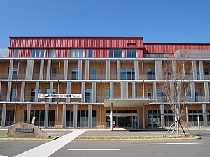
Azumino
City in Chūbu, Japan
Distance: Approx. 2431 meters
Latitude and longitude: 36.30393611,137.90578056
Azumino (安曇野市, Azumino-shi) is a city located in Nagano Prefecture, Japan. As of 1 March 2019, the city had an estimated population of 97,761 in 39744 households. and a population density of 290 persons per km2.

Daio Wasabi Farm
Distance: Approx. 5972 meters
Latitude and longitude: 36.3388,137.9091
The Daiō Wasabi Farm (大王わさび農場, Daiō Wasabi Nōjō) is a wasabi farm established in 1915 and located in Azumino, Nagano Prefecture near the center of Honshū, the main island of Japan. It is a popular tourist spot due to its watermills and the river that runs through it. A restaurant offers wasabi-flavoured ice cream and other wasabi-themed products.

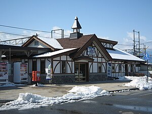
Tazawa Station
Railway station in Azumino, Nagano Prefecture, Japan
Distance: Approx. 5020 meters
Latitude and longitude: 36.3019,137.9403
Tazawa Station (田沢駅, Tazawa-eki) is a train station in the city of Azumino, Nagano Prefecture, Japan, operated by East Japan Railway Company (JR East).
Toyoshina Station
Railway station in Azumino, Nagano Prefecture, Japan
Distance: Approx. 1834 meters
Latitude and longitude: 36.30021667,137.90096944
Toyoshina Station (豊科駅, Toyoshina-eki) is a railway station in the city of Azumino, Nagano Prefecture, Japan, operated by East Japan Railway Company (JR East).

Hotaka Station
Railway station in Azumino, Nagano Prefecture, Japan
Distance: Approx. 5763 meters
Latitude and longitude: 36.33980278,137.88183889
Hotaka Station (穂高駅, Hotaka-eki) is a train station in the city of Azumino, Nagano Prefecture, Japan, operated by East Japan Railway Company (JR East).

Azusabashi Station
Railway station in Azumino, Nagano Prefecture, Japan
Distance: Approx. 5027 meters
Latitude and longitude: 36.25062306,137.91805278
Azusabashi Station (梓橋駅, Azusabashi-eki) is a railway station on the Ōito Line in Azumino, Nagano, Japan, operated by East Japan Railway Company (JR East).
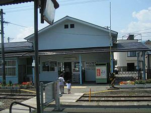
Hitoichiba Station
Railway station in Azumino, Nagano Prefecture, Japan
Distance: Approx. 3535 meters
Latitude and longitude: 36.25961389,137.90413333
Hitoichiba Station (一日市場駅, Hitoichiba-eki) is a train station in the city of Azumino, Nagano Prefecture, Japan, operated by East Japan Railway Company (JR East).

Nakagaya Station
Railway station in Azumino, Nagano Prefecture, Japan
Distance: Approx. 2187 meters
Latitude and longitude: 36.27347778,137.903125
Nakagaya Station (中萱駅, Nakagaya-eki) is a train station in the city of Azumino, Nagano Prefecture, Japan, operated by East Japan Railway Company (JR East).
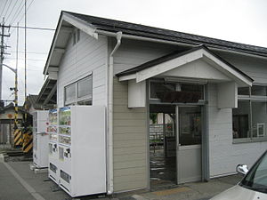
Minami-Toyoshina Station
Railway station in Azumino, Nagano Prefecture, Japan
Distance: Approx. 1522 meters
Latitude and longitude: 36.29177222,137.90335833
Minami-Toyoshina Station (南豊科駅, Minami-Toyoshina-eki) is a train station in the city of Azumino, Nagano Prefecture, Japan, operated by East Japan Railway Company (JR East).
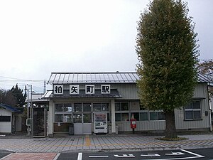
Hakuyachō Station
Railway station in Azumino, Nagano Prefecture, Japan
Distance: Approx. 3896 meters
Latitude and longitude: 36.32318389,137.88831306
Hakuyachō Station (柏矢町駅, Hakuyachō-eki) is a train station in the city of Azumino, Nagano Prefecture, Japan, operated by East Japan Railway Company (JR East).
Jōkyō Gimin Memorial Museum
Distance: Approx. 1813 meters
Latitude and longitude: 36.27396694,137.89680611
The Jōkyō Gimin Memorial Museum (貞享義民記念館, Jōkyō Gimin Kinen-kan) is a museum dedicated to the Jōkyō Uprising that occurred in the Azumidaira area of Shinano Province of Japan in 1686 (the third year of the Jōkyō era during the Edo period). The uprising, also called the Kasuke Uprising (the leader of the peasant uprising was Tada Kasuke), is portrayed by the museum to be a struggle for the right to life. Thus the founders of the memorial museum erected two plaques at the front entrance of the building.

Saigawa Dam (Nagano Prefecture)
Dam in Nagano Prefecture, Japan
Distance: Approx. 4465 meters
Latitude and longitude: 36.30713683,137.93086083
Saigawa Dam (犀川ダム, Saigawa-damu) is a dam in Nagano Prefecture, Japan on the Sai River. Its lake is also known as Swan Lake (白鳥湖, Hakuchō-ko) for the swans that come every winter.
Weather in this IP's area
broken clouds
16 Celsius
16 Celsius
16 Celsius
17 Celsius
1019 hPa
72 %
1019 hPa
953 hPa
10000 meters
0.51 m/s
75 %
06:26:34
16:40:06
