Country:
 Indonesia
Region:
City:
Latitude and Longitude:
Time Zone:
Postal Code:
IP information under different IP Channel
ip-api
Country
Region
City
ASN
Time Zone
ISP
Blacklist
Proxy
Latitude
Longitude
Postal
Route
IPinfo
Country
Region
City
ASN
Time Zone
ISP
Blacklist
Proxy
Latitude
Longitude
Postal
Route
MaxMind
Country
Region
City
ASN
Time Zone
ISP
Blacklist
Proxy
Latitude
Longitude
Postal
Route
Luminati
Country
IDASN
Time Zone
Asia/Jakarta
ISP
PT ADIZKA LINTAS DATA
Latitude
Longitude
Postal
db-ip
Country
Region
City
ASN
Time Zone
ISP
Blacklist
Proxy
Latitude
Longitude
Postal
Route
ipdata
Country
Region
City
ASN
Time Zone
ISP
Blacklist
Proxy
Latitude
Longitude
Postal
Route
Popular places and events near this IP address

Balikpapan
City in East Kalimantan, Indonesia
Distance: Approx. 6701 meters
Latitude and longitude: -1.27680556,116.82772222
Balikpapan is a seaport city in East Kalimantan, Indonesia. Located on the east coast of the island of Borneo, the city is the financial center of Kalimantan. Balikpapan is the city with the largest economy in Kalimantan with an estimated 2016 GDP at Rp 73.18 trillion.
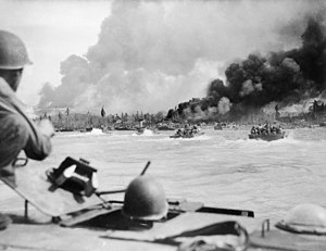
Battle of Balikpapan (1945)
1945 battle of World War II
Distance: Approx. 6701 meters
Latitude and longitude: -1.27680556,116.82772222
The Battle of Balikpapan was the concluding stage of Operation Oboe, the campaign to liberate Japanese-held British and Dutch Borneo. The landings took place on 1 July 1945. The Australian 7th Division, composed of the 18th, 21st and 25th Infantry Brigades, with a small number of Netherlands East Indies KNIL troops, made an amphibious landing, codenamed Operation Oboe Two, a few miles north of Balikpapan.

Persiba Stadium
Stadium in Balikpapan, Indonesia
Distance: Approx. 5440 meters
Latitude and longitude: -1.243852,116.830137
Persiba Stadium (also known as Parikesit Stadium) is a multi-use stadium in Balikpapan, Indonesia. It is currently used mostly for football matches and is used as the home stadium for Persiba Balikpapan. The stadium has a capacity of 12,500 people after the 2009 renovation.

Battle of Balikpapan (1942)
World War II battle on Borneo
Distance: Approx. 6382 meters
Latitude and longitude: -1.24611111,116.82166667
The First Battle of Balikpapan took place on 23–25 January 1942, off the major oil-producing town and port of Balikpapan, on Borneo, in the Netherlands East Indies. After capturing mostly-destroyed oilfields at Tarakan, Japanese forces send an ultimatum to the Dutch that they would be executed if they destroyed the oilfields there, to no avail. After destroying the oilfields, Dutch forces retreated inland, taking up positions in and around Samarinda II Airfield, while the Japanese landed and seized the also-destroyed refineries.

Balikpapan Bay
Bay in Indonesia
Distance: Approx. 8808 meters
Latitude and longitude: -1.25,116.8
Balikpapan Bay (Indonesian: Teluk Balikpapan), is a bay in Indonesia, near Borneo island close to the city of Balikpapan, East Kalimantan, Indonesia. The Indonesian company Pertamina has its largest oil refinery on the eastern side of the bay.

USS YMS-50
Minesweeper of the United States Navy
Distance: Approx. 9234 meters
Latitude and longitude: -1.3,116.81666667
USS YMS-50 was a United States Navy YMS-1-class auxiliary motor minesweeper during World War II. Laid down on 16 July 1941 at Wheeler Shipbuilding Corp., Whitestone, Long Island, New York, she was launched on 6 June 1942 and commissioned on 3 August. Assigned to the South West Pacific Area she was damaged by a dive bomber while covering the landings during the battle of Arawe, New Britain on 17 December 1943. Later while covering the landings during the battle of Balikpapan, Borneo she struck a mine on 18 June 1945 at 01°18′S 116°49′E and was scuttled by the light cruiser Denver.

Bekapai Park
Distance: Approx. 6119 meters
Latitude and longitude: -1.27666667,116.83388889
Bekapai Park is a park situated in the city of Balikpapan, East Kalimantan. The park is located in the middle of the city, close to nearby shopping centers. There is a fountain made of stainless steel and a bronze sculpture in the middle of the park.
Batakan Stadium
Football stadium in Balikpapan, East Kalimantan, Indonesia
Distance: Approx. 7285 meters
Latitude and longitude: -1.23316667,116.94333333
The Batakan Stadium of Balikpapan (Indonesian: Stadion Batakan Balikpapan) is a football stadium in Balikpapan, East Kalimantan, Indonesia. The stadium hosts Liga 1 club Borneo Samarinda and Liga 2 club Persiba Balikpapan. The stadium has a capacity of 40,000.

Balikpapan Sport and Convention Center
Multipurpose Indoor Arena in Balikpapan, East Kalimantan, Indonesia
Distance: Approx. 1267 meters
Latitude and longitude: -1.243471,116.890244
Balikpapan Sport and Convention Center or can be locally referred to as Dome Balikpapan is a multipurpose indoor arena located in Balikpapan, Indonesia. The building was built by the Government of Balikpapan for 2008 Pekan Olahraga Nasional.
Port of Semayang
Port in Indonesia
Distance: Approx. 8766 meters
Latitude and longitude: -1.273316,116.805409
Port of Semayang is a seaport located in Balikpapan, East Kalimantan, Indonesia. The port is the largest and busiest port in East Kalimantan. The port serves as a transport hub between East Kalimantan and other eastern Indonesian regions such as Sulawesi and East Nusa Tenggara.
Weather in this IP's area
overcast clouds
28 Celsius
34 Celsius
28 Celsius
28 Celsius
1013 hPa
94 %
1013 hPa
1010 hPa
10000 meters
2.06 m/s
250 degree
100 %
05:52:49
18:01:24