Country:
 Australia
Region:
City:
Latitude and Longitude:
Time Zone:
Postal Code:
IP information under different IP Channel
ip-api
Country
Region
City
ASN
Time Zone
ISP
Blacklist
Proxy
Latitude
Longitude
Postal
Route
IPinfo
Country
Region
City
ASN
Time Zone
ISP
Blacklist
Proxy
Latitude
Longitude
Postal
Route
MaxMind
Country
Region
City
ASN
Time Zone
ISP
Blacklist
Proxy
Latitude
Longitude
Postal
Route
Luminati
Country
AURegion
qld
City
brisbane
ASN
Time Zone
Australia/Brisbane
ISP
TPG Telecom Limited
Latitude
Longitude
Postal
db-ip
Country
Region
City
ASN
Time Zone
ISP
Blacklist
Proxy
Latitude
Longitude
Postal
Route
ipdata
Country
Region
City
ASN
Time Zone
ISP
Blacklist
Proxy
Latitude
Longitude
Postal
Route
Popular places and events near this IP address

Toowong
Suburb of Brisbane, Queensland, Australia
Distance: Approx. 480 meters
Latitude and longitude: -27.4816,152.99
Toowong ( tə-WONG) is a riverside suburb in the City of Brisbane, Queensland, Australia. In the 2021 census, Toowong had a population of 12,556 people with a median weekly household income of $1,927.

Auchenflower railway station
Railway station in Brisbane, Queensland, Australia
Distance: Approx. 504 meters
Latitude and longitude: -27.476,152.9969
Auchenflower railway station is located on the Main line in Queensland, Australia. It serves the Brisbane suburb of Auchenflower, adjacent to the Wesley Hospital.
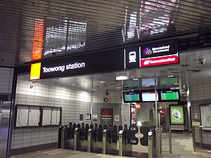
Toowong railway station
Railway station in Brisbane, Queensland, Australia
Distance: Approx. 504 meters
Latitude and longitude: -27.476,152.9969
Toowong railway station is located on the Main line in Queensland, Australia. It serves the Brisbane suburb of Toowong. It is the closest station to the St Lucia campus of the University of Queensland.
Brisbane College of Theology
Theological college in Brisbane, Australia
Distance: Approx. 265 meters
Latitude and longitude: -27.477925,152.99319167
Brisbane College of Theology, located in Auchenflower, Brisbane, Queensland, Australia, was an ecumenical theological education consortium (1983–2009), comprising St Francis' Theological College (Anglican), St Paul's Theological College (Roman Catholic), (formerly under the operations of the Pius XII Seminary), and Trinity Theological College (Uniting). The B.C.T was inaugurated on March 28, 1983. It was based at Raymont Lodge in Auchenflower but effectively operated from this location and also concurrently at Saint Francis Theological College in Milton and Pius XII/ Saint Paul's Theological College at Banyo.

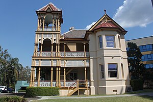
Regatta Hotel
Historically significant hotel in Brisbane, Australia
Distance: Approx. 325 meters
Latitude and longitude: -27.4825,152.9962
Regatta Hotel is a heritage-listed hotel at 543 Coronation Drive on the corner of Sylvan Road, Toowong, City of Brisbane, Queensland, Australia. It faces the Toowong Reach of the Brisbane River and was named after the rowing regattas held there. It was designed by Richard Gailey and built in 1886 by George Gazzard.

Regatta ferry wharf
Ferry wharf in Toowong, Brisbane, Australia
Distance: Approx. 427 meters
Latitude and longitude: -27.4832,152.9969
Regatta ferry wharf is located on the northern side of the Brisbane River serving the Brisbane suburb of Toowong in Queensland, Australia. It is served by RiverCity Ferries' CityCat services.

Raymont Residential College
Historic site in Queensland, Australia
Distance: Approx. 282 meters
Latitude and longitude: -27.4778,152.9931
Raymont Residential College (commonly known as Raymont College) is a student residential college with its offices in Drysllwyn, a heritage-listed mansion at 47 Cadell Street, Auchenflower, City of Brisbane, Queensland, Australia. It is an activity of the Uniting Church in Australia, Queensland Synod. The college shares its grounds with Trinity College Queensland and the Queensland Synod office.

Wesley Hospital (Brisbane)
Hospital in Queensland, Australia
Distance: Approx. 399 meters
Latitude and longitude: -27.47758333,152.9975
The Wesley Hospital is a private hospital located in the suburb of Auchenflower in Brisbane, Queensland, Australia. The hospital currently has over 530 beds and offers a large range of clinical services. It is owned and operated by UnitingCare Health, part of the Uniting Church in Australia.
Moorlands, Auchenflower
Historic site in Queensland, Australia
Distance: Approx. 419 meters
Latitude and longitude: -27.479,152.9986
Moorlands is a heritage-listed villa at 451 Coronation Drive, Auchenflower, Queensland, Australia. It was designed by Richard Gailey and was built c. 1892 by contractor Arthur Smith. It was added to the Queensland Heritage Register on 21 August 1992.

Toowong Municipal Library Building
Historic site in Queensland, Australia
Distance: Approx. 393 meters
Latitude and longitude: -27.4835,152.995
The Toowong Municipal Library Building is heritage-listed former public library at 579–583 Coronation Drive, Toowong, City of Brisbane, Queensland, Australia. It was designed by James Birrell and built in 1961 by Stuart Brothers. It was added to the Queensland Heritage Register on 28 August 1998.

Toowong Memorial Park
Historic site in Queensland, Australia
Distance: Approx. 78 meters
Latitude and longitude: -27.4797,152.9938
Toowong Memorial Park is a heritage-listed memorial and park at 65 Sylvan Road, Toowong, City of Brisbane, Queensland, Australia. It was designed by George Rae and built c. 1922 by Andrew Lang Petrie Monumental Works. It was added to the Queensland Heritage Register on 4 September 2007.
Auchenflower Stadium
Distance: Approx. 392 meters
Latitude and longitude: -27.47722222,152.99694444
Auchenflower Stadium is an Australian basketball centre in Auchenflower, Queensland. The four-court arena was the home of NBL side Brisbane Bullets until 1983. During that time, it was often referred to as The Auchendome.
Weather in this IP's area
light rain
17 Celsius
17 Celsius
16 Celsius
19 Celsius
1019 hPa
92 %
1019 hPa
1018 hPa
10000 meters
3.09 m/s
160 degree
75 %
05:18:18
17:52:02