Country:
 Australia
Region:
City:
Latitude and Longitude:
Time Zone:
Postal Code:
IP information under different IP Channel
ip-api
Country
Region
City
ASN
Time Zone
ISP
Blacklist
Proxy
Latitude
Longitude
Postal
Route
IPinfo
Country
Region
City
ASN
Time Zone
ISP
Blacklist
Proxy
Latitude
Longitude
Postal
Route
MaxMind
Country
Region
City
ASN
Time Zone
ISP
Blacklist
Proxy
Latitude
Longitude
Postal
Route
Luminati
Country
AURegion
nsw
City
sydney
ASN
Time Zone
Australia/Sydney
ISP
TIGGEE
Latitude
Longitude
Postal
db-ip
Country
Region
City
ASN
Time Zone
ISP
Blacklist
Proxy
Latitude
Longitude
Postal
Route
ipdata
Country
Region
City
ASN
Time Zone
ISP
Blacklist
Proxy
Latitude
Longitude
Postal
Route
Popular places and events near this IP address

Sydney Airport
International airport serving Sydney, New South Wales, Australia
Distance: Approx. 879 meters
Latitude and longitude: -33.94611111,151.17722222
Sydney Kingsford Smith Airport (IATA: SYD, ICAO: YSSY) — colloquially Mascot Airport, Kingsford Smith Airport, or Sydney Airport — is an international airport serving Sydney, New South Wales, Australia, 8 km (5.0 mi) south of the Sydney central business district, in the suburb of Mascot. Sydney Airport is the busiest airport in Oceania. It is the primary airport serving Sydney and is a primary hub for Qantas, as well as a secondary hub for Virgin Australia and Jetstar, and a focus city for Rex Airlines.

Brighton-Le-Sands, New South Wales
Suburb of Sydney, New South Wales, Australia
Distance: Approx. 1541 meters
Latitude and longitude: -33.959,151.157
Brighton Le Sands (formerly Brighton-le-Sands and also known simply as Brighton or Brighton Beach), is a suburb in southern Sydney, in the state of New South Wales, Australia. Brighton Le Sands is located 13 kilometres south of the Sydney central business district, on the western shore of Botany Bay. Brighton Le Sands is in the local government area of the Bayside Council and is part of the St George area.

Kyeemagh
Suburb of Sydney, New South Wales, Australia
Distance: Approx. 1439 meters
Latitude and longitude: -33.94829,151.15711
Kyeemagh ( ky-EE-mə) is a suburb in southern Sydney, in the state of New South Wales, Australia. It is 12 kilometres south of the Sydney central business district, on the western shore of Botany Bay. Kyeemagh is in the local government area of the Bayside Council and is part of the St George area.

Cooks River
River in Sydney, New South Wales, Australia
Distance: Approx. 499 meters
Latitude and longitude: -33.94916667,151.16833333
The Cooks River, a semi-mature tide-dominated drowned valley estuary, is a tributary of Botany Bay, located in south-western Sydney, New South Wales, Australia. The course of the 23-kilometre-long (14 mi) urban waterway has been altered to accommodate various developments along its shore. It serves as part of a stormwater system for the 100 square kilometres (39 sq mi) of its watershed, and many of the original streams running into it have been turned into concrete lined channels.
St George Stadium
Distance: Approx. 1663 meters
Latitude and longitude: -33.94722222,151.155
Barton Park Sports Complex was a soccer stadium in Banksia, New South Wales, Australia.

Advance Airlines Flight 4210
1980 aviation accident in Sydney
Distance: Approx. 879 meters
Latitude and longitude: -33.94611111,151.17722222
Advance Airlines Flight 4210 was a scheduled passenger flight which crashed at Sydney Airport on 21 February 1980, killing all 13 people on board the Advance Airlines Beech Beechcraft King Air 200. After taking off on runway 25 for a scheduled flight the aircraft's left (port) engine failed and the pilot requested an emergency landing on runway 34. The plane crashed into the sea wall while attempting the emergency landing.

Rockdale Ilinden Sports Centre (Arncliffe, New South Wales)
Distance: Approx. 1695 meters
Latitude and longitude: -33.94277778,151.15777778
Rockdale Ilinden Sports Centre was located on the grounds of Barton Park in Arncliffe, New South Wales in Australia. It was the home ground of the Rockdale Ilinden Football Club, who played in the New South Wales Super League. A new Rockdale Ilinden Sports Centre has been constructed at Bicentennial Park South, 468 West Botany Street, Rockdale.

Endeavour Bridge
Bridge in Australia
Distance: Approx. 711 meters
Latitude and longitude: -33.947098,151.167884
The Endeavour Bridge is a road bridge that carries the General Holmes Drive (A1) across the Cooks River, from Mascot to Kyeemagh in the Bayside Council local government area in southern Sydney, New South Wales, Australia. The bridge is located adjacent to the river mouth, where the Cooks River empties into Botany Bay. The bridge is maintained by Transport for NSW, an agency of the Government of New South Wales.

Sewage Pumping Station 38
Sewage pumping station in Sydney, Australia
Distance: Approx. 1821 meters
Latitude and longitude: -33.9426,151.1874
Sewage Pumping Station 38 is a heritage-listed sewerage pumping station located on General Holmes Drive, in the Sydney suburb of Mascot, in the Bayside Council local government area of New South Wales, Australia. It was designed and built by the Metropolitan Water Sewerage and Drainage Board. It is also known as SPS 38, Mascot Sewage Pumping Station and SP0038.
Kyeemagh Market Gardens
Historic site in New South Wales, Australia
Distance: Approx. 1309 meters
Latitude and longitude: -33.949,151.1583
The Kyeemagh Market Gardens are heritage-listed market gardens at Occupation Road, Kyeemagh, Bayside Council, New South Wales, Australia. It was established from 1892. It is also known as Occupation Road Market Gardens, Chinese Market Gardens and Rockdale Market Gardens.
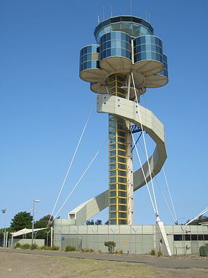
Sydney Airport Air Traffic Control Tower
Historic site in New South Wales, Australia
Distance: Approx. 1154 meters
Latitude and longitude: -33.9455,151.1809
Sydney Airport Air Traffic Control Tower is a heritage-listed air traffic control tower at Lawrence Hargreaves Drive, Sydney Airport, New South Wales, Australia. It was added to the Australian Commonwealth Heritage List on 22 January 2016.

1994 South Pacific Airmotive DC-3 crash
Douglas DC-3 crash in Sydney, New South Wales
Distance: Approx. 879 meters
Latitude and longitude: -33.94611111,151.17722222
The 1994 South Pacific Airmotive DC-3 crash took place on 24 April 1994, when a Douglas DC-3 airliner operated by South Pacific Airmotive, tail number VH-EDC, ditched into Botany Bay shortly after takeoff from Sydney Airport in Sydney, New South Wales, Australia. The cause of the crash was determined by the Bureau of Air Safety Investigation (BASI; now the Australian Transport Safety Bureau, or ATSB) to have been a power loss in the aircraft's left engine caused by an inlet valve being stuck in the open position, compounded by inadequate action on the part of the pilots; Rod Lovell, the pilot in command of the flight, has disputed BASI's conclusions.
Weather in this IP's area
broken clouds
14 Celsius
13 Celsius
13 Celsius
15 Celsius
1018 hPa
71 %
1018 hPa
1018 hPa
10000 meters
4.16 m/s
7.87 m/s
273 degree
75 %
06:04:35
17:41:52