103.137.24.1 - IP Lookup: Free IP Address Lookup, Postal Code Lookup, IP Location Lookup, IP ASN, Public IP
Country:
Region:
City:
Location:
Time Zone:
Postal Code:
ISP:
ASN:
language:
User-Agent:
Proxy IP:
Blacklist:
IP information under different IP Channel
ip-api
Country
Region
City
ASN
Time Zone
ISP
Blacklist
Proxy
Latitude
Longitude
Postal
Route
db-ip
Country
Region
City
ASN
Time Zone
ISP
Blacklist
Proxy
Latitude
Longitude
Postal
Route
IPinfo
Country
Region
City
ASN
Time Zone
ISP
Blacklist
Proxy
Latitude
Longitude
Postal
Route
IP2Location
103.137.24.1Country
Region
azad jammu and kashmir
City
new mirpur
Time Zone
Asia/Karachi
ISP
Language
User-Agent
Latitude
Longitude
Postal
ipdata
Country
Region
City
ASN
Time Zone
ISP
Blacklist
Proxy
Latitude
Longitude
Postal
Route
Popular places and events near this IP address

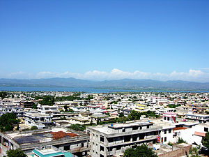
Mirpur, Azad Kashmir
City in Azad Kashmir, Pakistan
Distance: Approx. 3304 meters
Latitude and longitude: 33.15,73.73333333
Mirpur (Potwari: مرپر [mɪɾˈpəɾᵊ]; Urdu: ميرپور [miːɾˈpuːɾ]), officially known as New Mirpur City (Urdu: نیا میرپر شہر, romanized: nayā mīrpur shèher), is the capital of Mirpur district located in Azad Kashmir, Pakistan which has been subject of the larger Kashmir dispute between Pakistan and India since 1947. It is the second largest city of Azad Kashmir and the 74th largest city in Pakistan. A significant portion of the population from the district, the Mirpuri diaspora, migrated to the United Kingdom in the mid-to-late 1950s and in the early 1960s, mostly to West Yorkshire, East and West Midlands, Greater Manchester, Birmingham, Luton, Peterborough, Derby, Newcastle, Middlesbrough, Sheffield, East London and other parts of England.

Mirpur District
District of Azad Jammu and Kashmir, Pakistan
Distance: Approx. 3304 meters
Latitude and longitude: 33.15,73.73333333
Mirpur District (Urdu: ضلع میرپور) is a district of Pakistan-administered Azad Jammu and Kashmir region. It is one of the 10 districts of Pakistan's territory of Azad Kashmir. The Mirpur District is bounded on the north by the Kotli District, on the east by the Bhimber District, on the south by the Gujrat District of Punjab, Pakistan, on the south-west by the Jhelum District of Punjab, Pakistan, and on the west by its Rawalpindi District.
Quaid-e-Azam Stadium
Cricket stadium in Pakistan
Distance: Approx. 1942 meters
Latitude and longitude: 33.14375,73.74669722
The Quaid-e-Azam Stadium (Urdu: قائدِ اعظم سٹیڈیم; also known as Mirpur Cricket Stadium) is a cricket stadium in sector F/2 Mirpur, Azad Kashmir, Pakistan. It is the home of Azad Jammu and Kashmir cricket team. The stadium has a seating capacity of 16,000, making it the largest stadium in Azad Kashmir.
Andrah Kalan
Distance: Approx. 6516 meters
Latitude and longitude: 33.18333333,73.81666667
Andrah Kalan is a village in the Chakswari tehsil of Mirpur District of Azad Kashmir, Pakistan.
Chak Haryam
Village in Pakistan
Distance: Approx. 5361 meters
Latitude and longitude: 33.16666667,73.81666667
Chak Haryam (Urdu:چک ہریام) is a village, near Islamgarh in the Chakswari tehsil of Mirpur District of Azad Kashmir, Pakistan.
Chechian, Mirpur
Village in Azad Kashmir, Pakistan
Distance: Approx. 6892 meters
Latitude and longitude: 33.08111111,73.75277778
Chechian is a village the Mirpur Tehsil of Mirpur District of Azad Kashmir, Pakistan.

Mirpur University of Science & Technology
University in Mirpur, Azad Kashmir
Distance: Approx. 2299 meters
Latitude and longitude: 33.1502,73.74486944
Mirpur University of Science & Technology (میرپور یونیورسٹی براۓ سائنس اور ٹیکنالوجی) was formerly a constituent college of University of Azad Jammu and Kashmir as University College of Engineering & Technology Mirpur. It is a state university.

Chitterpari
Town in Azad Kashmir, Pakistan
Distance: Approx. 6910 meters
Latitude and longitude: 33.129182,73.694821
Chitterpari (Chattar Pari) (Urdu: چترپڑی) is a rapidly expanding town situated near Mirpur, in the state of Azad Kashmir in Pakistan. Its population is nearly 30,000. Chitterpari is located in the northern plains of the Punjab region, about 6 kilometres (3.7 mi) west-southwest of Mirpur, 95 kilometres (59 mi) north-northwest of Islamabad, and 1,000 kilometres (620 mi) northeast of Karachi.
Mohi-ud-Din Islamic Medical College
Medical College of Azad Jammu & Kashmir
Distance: Approx. 6394 meters
Latitude and longitude: 33.10868056,73.71136389
Mohi-ud-Din Islamic Medical College (محی الدین اسلامی طبی کالج) is the first Medical College of Azad Jammu & Kashmir in either the public or the private sector.

New Bong Escape Hydropower Project
Dam in Mangla, Azad Kashmir
Distance: Approx. 7660 meters
Latitude and longitude: 33.092529,73.710046
The New Bong Escape Hydropower Project is a privately owned 84 MW run-of-the-river project located on Jhelum River 7.5 km downstream of the 1,070 MW Mangla Dam, a major multi-purpose water storage project commissioned. It is about 120 km from Islamabad, the capital city of Pakistan. The project commenced commercial operations on 23 March, 2013 and has the distinction of being Pakistan and AJ&K’s first hydropower IPP. By developing a bankable framework this trendsetting project has paved the way for rapid and full scale development of Pakistan and AJ&K’s hydropower potential.

Rathoa Haryam Bridge
Pakistani construction
Distance: Approx. 4131 meters
Latitude and longitude: 33.16027778,73.80583333
Rathoa Haryam Bridge, Mirpur, also known as the Islamgarh Bridge is a three kilometre long bridge currently under construction, located in the Mirpur District of Azad Jammu Kashmir in Pakistan. In 2011, the cost of the bridge was estimated to be around Rs. 6.48 billion.

2019 Kashmir earthquake
Earthquake in Kashmir
Distance: Approx. 3987 meters
Latitude and longitude: 33.106,73.766
The 2019 Kashmir earthquake struck regions of Pakistan with an epicentre in Azad Kashmir on 24 September at 16:02 local time (11:02 UTC). It had a magnitude of 5.4 Mww and a maximum felt intensity of VII (Very strong) on the Modified Mercalli intensity scale or VIII (Heavily damaging) on the European macroseismic scale. There was severe damage in Mirpur District, causing the deaths of 40 people and injuring a further 850.
Weather in this IP's area
scattered clouds
14 Celsius
13 Celsius
14 Celsius
14 Celsius
1025 hPa
28 %
1025 hPa
984 hPa
10000 meters
3.17 m/s
3.27 m/s
318 degree
36 %