103.134.74.243 - IP Lookup: Free IP Address Lookup, Postal Code Lookup, IP Location Lookup, IP ASN, Public IP
Country:
 USA
USARegion:
City:
Location:
Time Zone:
Postal Code:
ISP:
ASN:
language:
User-Agent:
Proxy IP:
Blacklist:
IP information under different IP Channel
ip-api
Country
Region
City
ASN
Time Zone
ISP
Blacklist
Proxy
Latitude
Longitude
Postal
Route
db-ip
Country
Region
City
ASN
Time Zone
ISP
Blacklist
Proxy
Latitude
Longitude
Postal
Route
IPinfo
Country
Region
City
ASN
Time Zone
ISP
Blacklist
Proxy
Latitude
Longitude
Postal
Route
IP2Location
103.134.74.243Country
usRegion
louisiana
City
supreme
Time Zone
ISP
Language
User-Agent
Latitude
Longitude
Postal
ipdata
Country
Region
City
ASN
Time Zone
ISP
Blacklist
Proxy
Latitude
Longitude
Postal
Route
Popular places and events near this IP address
Assumption Parish, Louisiana
Parish in Louisiana, United States
Distance: Approx. 8847 meters
Latitude and longitude: 29.9,-91.06
Assumption Parish (French: Paroisse de l'Assomption, Spanish: Parroquia de la Asunción) is a parish located in the U.S. state of Louisiana. As of the 2020 census, the population was 21,039. Its parish seat is Napoleonville.

Labadieville, Louisiana
Census-designated place in Louisiana, United States
Distance: Approx. 3937 meters
Latitude and longitude: 29.8325,-90.95472222
Labadieville is a census-designated place (CDP) in Assumption Parish, Louisiana, United States. The population was 1,854 at the 2010 census. It is part of the Pierre Part Micropolitan Statistical Area.
Napoleonville, Louisiana
Village in Louisiana, United States
Distance: Approx. 9766 meters
Latitude and longitude: 29.93777778,-91.02666667
Napoleonville, is a village and the parish seat of Assumption Parish, in the U.S. state of Louisiana. The population was 660 at the 2010 census. It is part of the Pierre Part Micropolitan Statistical Area.
Supreme, Louisiana
Census-designated place in Louisiana, United States
Distance: Approx. 399 meters
Latitude and longitude: 29.86,-90.98527778
Supreme is a census-designated place (CDP) in Assumption Parish, Louisiana, United States. The population was 1,052 at the 2010 census. In 2020, its population was 839.

Madewood Plantation House
United States historic place
Distance: Approx. 7633 meters
Latitude and longitude: 29.927,-90.99444
Madewood Plantation House, also known as Madewood, is a former sugarcane plantation house on Bayou Lafourche, near Napoleonville, Louisiana. It is located approximately two miles east of Napoleonville on Louisiana Highway 308. A National Historic Landmark, the 1846 house is architecturally significant as the first major work of Henry Howard, and as one of the finest Greek Revival plantation houses in the American South.
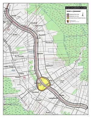
Battle of Georgia Landing
Battle of the American Civil War
Distance: Approx. 112 meters
Latitude and longitude: 29.8604,-90.9811
The Battle of Georgia Landing or Battle of Labadieville (October 27, 1862) was fought between a Union Army force led by Brigadier General Godfrey Weitzel and a Confederate States Army force commanded by Brigadier General Alfred Mouton near Labadieville, Assumption Parish, Louisiana, during the American Civil War. After a sharp clash, the Union troops compelled Mouton's outnumbered force to retreat. Major General Benjamin F. Butler ordered a three-pronged invasion of the Bayou Lafourche district.

Edward Douglass White House
Historic house in Louisiana, United States
Distance: Approx. 7786 meters
Latitude and longitude: 29.8242,-90.91152
The Edward Douglass White House, also known as Edward Douglass White Louisiana State Commemorative Area, is a state historic site near Thibodaux, Louisiana. The house was home to both Edward Douglass White, Sr., the tenth governor of the state of Louisiana, and his son, Edward Douglass White, a U.S. senator and a Chief Justice of the United States. It was designated a National Historic Landmark in 1976 for its association with the latter White, who was in the 7-1 majority ruling on Plessy v.
St. Anne Catholic Church (Napoleonville, Louisiana)
Historic church in Louisiana, United States
Distance: Approx. 9776 meters
Latitude and longitude: 29.93784,-91.02676
The St. Anne Catholic Church in Napoleonville, Louisiana is a historic Roman Catholic church which was built in 1909. It is located about four blocks inland from Bayou Lafourche at 417 St.

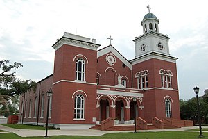
St. Philomene Catholic Church and Rectory
Historic church in Louisiana, United States
Distance: Approx. 3381 meters
Latitude and longitude: 29.83907,-90.95518
St. Philomene Catholic Church and Rectory is a historic Roman Catholic church along Louisiana Highway 1 in Labadieville, Assumption Parish, Louisiana. It was built in c.1888 and added to the National Register of Historic Places in 1983.

LaBarre House
United States historic place
Distance: Approx. 7699 meters
Latitude and longitude: 29.9266,-91.00005
The LaBarre House, in Assumption Parish, Louisiana, near Napoleonville, Louisiana, was built in 1909. It was listed on the National Register of Historic Places in 2008. Architecture: Queen Anne Free Classic It is located at 4371 Louisiana Highway 1, about 1.7 miles (2.7 km) southeast of Napoleonville.
Cancienne, Louisiana
Unincorporated community in Louisiana
Distance: Approx. 6248 meters
Latitude and longitude: 29.90027778,-91.02555556
Cancienne is a populated place located within the Parish Governing Authority District 5, a minor civil division of Assumption Parish, Louisiana. The elevation of Cancienne is 10 feet and Cancienne appears on the Napoleonville U.S. Geological Survey Map.
Weather in this IP's area
broken clouds
18 Celsius
19 Celsius
18 Celsius
19 Celsius
1009 hPa
98 %
1009 hPa
1008 hPa
10000 meters
4.96 m/s
13.96 m/s
192 degree
74 %