103.134.4.175 - IP Lookup: Free IP Address Lookup, Postal Code Lookup, IP Location Lookup, IP ASN, Public IP
Country:
 India
IndiaRegion:
City:
Location:
Time Zone:
Postal Code:
ISP:
ASN:
language:
User-Agent:
Proxy IP:
Blacklist:
IP information under different IP Channel
ip-api
Country
Region
City
ASN
Time Zone
ISP
Blacklist
Proxy
Latitude
Longitude
Postal
Route
db-ip
Country
Region
City
ASN
Time Zone
ISP
Blacklist
Proxy
Latitude
Longitude
Postal
Route
IPinfo
Country
Region
City
ASN
Time Zone
ISP
Blacklist
Proxy
Latitude
Longitude
Postal
Route
IP2Location
103.134.4.175Country
inRegion
maharashtra
City
umele
Time Zone
Asia/Kolkata
ISP
Language
User-Agent
Latitude
Longitude
Postal
ipdata
Country
Region
City
ASN
Time Zone
ISP
Blacklist
Proxy
Latitude
Longitude
Postal
Route
Popular places and events near this IP address

Naigaon
Village in Maharashtra, India
Distance: Approx. 1228 meters
Latitude and longitude: 19.351467,72.846343
Naigaon is located in Palghar district of Indian State of Maharashtra. It is linked by the Versova Bridge /Ghodbunder Bridge to Navghar, which is connected from the east side of the settlement by the National Highway. It is located in the Vasai taluka and comes under Police Jurisdiction of Mira-Bhayander, Vasai-Virar Police Commissionerate.

Ulhas River
River in Maharashtra, India
Distance: Approx. 6596 meters
Latitude and longitude: 19.3,72.83333333
The Ulhas River is a river in Maharashtra, India. It is in the Thane, Raigad, and Pune districts of that state. It flows north and west from it source to where it splits into Vasai Creek and Thane Creek, near Thane.

Vasai Creek
Creek in Maharashtra, India
Distance: Approx. 6268 meters
Latitude and longitude: 19.315,72.875
Vasai Creek, previously Bassein Creek, is an estuary and one of the two main distributaries of the Ulhas River, in Konkan division of Maharashtra, India. The Ulhas splits at the northeast corner of Salsette island into its two main distributaries, the other one being the Thane Creek, both of which empty into the Arabian Sea. The creek forms the northern boundary of Salsette island and separates the island from mainland of Konkan.
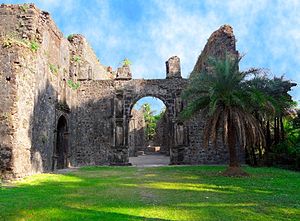
Fort Vasai
Fort in Vasai, Maharashtra, India
Distance: Approx. 4010 meters
Latitude and longitude: 19.33027778,72.815
Fort Vasai (Vasai killa in Marathi, Fortaleza de São Sebastião de Baçaim in Portuguese, Fort Bassein in English) is a ruined fort of the town of Vasai (Bassein), Konkan Division, Maharashtra, India. The structure was formally christened as the Fort of St Sebastian in the Indo-Portuguese era. The fort is a monument of national importance and is protected by the Archaeological Survey of India.

Gokhivare
Census town in Maharashtra, India
Distance: Approx. 5985 meters
Latitude and longitude: 19.4125,72.8445
Gokhivare is a census town in Vasai-Virar taluka of Palghar district in the Indian state of Maharashtra. Until recently when Palghar district was formed on 1 August 2014, Gokhivare came under the original Thane district. Gokhivare is governed by Vasai-Virar Municipal Corporation.
Bhayandar
Suburb in Mumbai, Maharashtra, India
Distance: Approx. 5612 meters
Latitude and longitude: 19.31,72.85
Bhayandar also spells as Bhaindar or Bhayander is a suburb located in the western suburbs of Mumbai and the northern most suburb of the island on the western side, near the Vasai Creek. It has a large Marathi, Aagri, Koli and other mixed populations as well.
Manickpur
Village in Maharashtra
Distance: Approx. 2261 meters
Latitude and longitude: 19.377293,72.828332
Manickpur is a small village in the Vasai (Bassein) township of the Palghar district in the Maharashtra, India.

Roman Catholic Diocese of Vasai
Roman Catholic diocese in Maharashtra, India
Distance: Approx. 2872 meters
Latitude and longitude: 19.3511,72.8119
The Roman Catholic Diocese of Vasai (Latin: Vasaien(sis)) is a diocese located in the city of Vasai in the ecclesiastical province of Bombay in India.

Vasai Assembly constituency
Constituency of the Maharashtra legislative assembly in India
Distance: Approx. 3538 meters
Latitude and longitude: 19.39,72.83
Vasai Assembly constituency is one of the 288 Vidhan Sabha (Legislative Assembly) constituencies of Maharashtra state in western India. It is one of the six Vidhan Sabha constituencies located in Palghar district. Vasai is part of Palghar Lok Sabha constituency along with five other Vidhan Sabha constituencies in Palghar district, namely Dahanu, Vikramgad, Palghar, Boisar and Nalasopara.
Vadavali
Village in Maharashtra
Distance: Approx. 2028 meters
Latitude and longitude: 19.3417423,72.832042
Vadavali is a village in the Palghar district of Maharashtra, India. It is located in the Talasari taluka.
St. Aloysius High School, Nallasopara
Private school in Nala Sopara, Maharashtra, India
Distance: Approx. 6217 meters
Latitude and longitude: 19.4145,72.8304
St. Aloysius High School is a high school in Nalasopara, Maharashtra, India. It is one of the oldest schools in the Mumbai suburbs.

Chandika Devi Temple, Juchandra
Hindu temple
Distance: Approx. 4598 meters
Latitude and longitude: 19.36027778,72.88166667
Chandika Devi Temple is a Hindu temple in Juchandra village, near Vasai and Naigaon, situated on a hill 400 feet above sea level. It is dedicated to the mother goddess Chandika.
Weather in this IP's area
clear sky
25 Celsius
25 Celsius
25 Celsius
25 Celsius
1011 hPa
55 %
1011 hPa
1007 hPa
10000 meters
2.39 m/s
2.54 m/s
350 degree