Country:
 Australia
Region:
City:
Latitude and Longitude:
Time Zone:
Postal Code:
IP information under different IP Channel
ip-api
Country
Region
City
ASN
Time Zone
ISP
Blacklist
Proxy
Latitude
Longitude
Postal
Route
IPinfo
Country
Region
City
ASN
Time Zone
ISP
Blacklist
Proxy
Latitude
Longitude
Postal
Route
MaxMind
Country
Region
City
ASN
Time Zone
ISP
Blacklist
Proxy
Latitude
Longitude
Postal
Route
Luminati
Country
AURegion
nsw
City
sydney
ASN
Time Zone
Australia/Sydney
ISP
TPG Telecom Limited
Latitude
Longitude
Postal
db-ip
Country
Region
City
ASN
Time Zone
ISP
Blacklist
Proxy
Latitude
Longitude
Postal
Route
ipdata
Country
Region
City
ASN
Time Zone
ISP
Blacklist
Proxy
Latitude
Longitude
Postal
Route
Popular places and events near this IP address
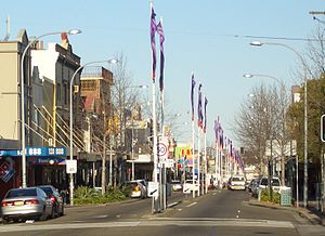
Marrickville, New South Wales
Suburb of Sydney, New South Wales, Australia
Distance: Approx. 272 meters
Latitude and longitude: -33.9051,151.1551
Marrickville is a suburb in the Inner West of Sydney, in the state of New South Wales, Australia. Marrickville is located 7 kilometres (4 miles) south-west of the Sydney central business district and is the largest suburb in the Inner West Council local government area. Marrickville sits on the northern bank of the Cooks River, opposite Earlwood and shares borders with Stanmore, Enmore, Newtown, St Peters, Sydenham, Tempe, Dulwich Hill, Hurlstone Park and Petersham.
Newington College
School in Australia
Distance: Approx. 1124 meters
Latitude and longitude: -33.898632,151.162139
Newington College is a multi-campus independent Uniting Church single-sex and co-educational early learning, primary and secondary day and boarding school for boys, located in Stanmore, an inner-western suburb of Sydney, New South Wales, Australia. Established in 1863 at Newington House, Silverwater, the college celebrated its sesquicentenary in 2013. The college is open to boys of all faiths and denominations.

Marrickville railway station
Railway station in Sydney, New South Wales, Australia
Distance: Approx. 779 meters
Latitude and longitude: -33.9143,151.1547
Marrickville railway station is a heritage-listed railway station located on the Bankstown railway line, serving the Sydney suburb of Marrickville. It was added to the New South Wales State Heritage Register on 2 April 1999.
Marrickville Council
Former local government area in New South Wales, Australia
Distance: Approx. 998 meters
Latitude and longitude: -33.9,151.15
Marrickville Council was a local government area located in the Inner West region of Sydney, Australia. It was originally created on 1 November 1861 as the "Municipality of Marrickville". On 12 May 2016, Marrickville Council was forcibly merged with Ashfield and Leichhardt councils into the newly formed Inner West Council.

Henson Park
Sports field in New South Wales, Australia
Distance: Approx. 388 meters
Latitude and longitude: -33.90444444,151.15833333
Henson Park is a multi purpose sports ground in Marrickville, New South Wales, Australia.

Casimir Catholic College
School in Australia
Distance: Approx. 555 meters
Latitude and longitude: -33.9107,151.1516
Casimir Catholic College is an independent Roman Catholic comprehensive co-educational secondary day school, located in the Sydney suburb of Marrickville, New South Wales, Australia.
Marrickville High School
School in Sydney, New South Wales, Australia
Distance: Approx. 176 meters
Latitude and longitude: -33.90583333,151.15583333
Marrickville High School is a co-educational, public secondary school, located in Marrickville, an inner western suburb of Sydney, New South Wales, Australia. The school is administered by the New South Wales Department of Education. Established in 1974, Marrickville High School has a non-selective enrolment policy and currently caters for approximately 470 students from years 7 to 12.

Dulwich High School of Visual Arts and Design
Arts school in Sydney, Australia
Distance: Approx. 1135 meters
Latitude and longitude: -33.90416667,151.14444444
Dulwich High School of Visual Arts & Design (abbreviated as DHSVAD) is a government coeducational specialist secondary school, with speciality in visual arts and design, located in Dulwich Hill, an inner western suburb of Sydney, New South Wales, Australia. Re-established in 2003, the school is run by the New South Wales Department of Education and Training. The School offers a comprehensive education program with a strong focus on visual arts and design throughout all years and subjects.
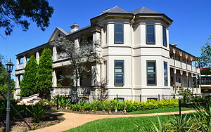
Stead House
House in New South Wales, Australia
Distance: Approx. 1210 meters
Latitude and longitude: -33.9061,151.1691
Stead House is a Victorian Italianate residence located at 12 Leicester Street, Marrickville, an inner western suburb of Sydney, New South Wales, Australia. The residence was established as Waterloo Villa in the early 1850s by Archibald Mitchell on part of the 12-hectare (30-acre) grant known as Wain's Farm. Stead House is an excellent example of a remnant grand estate house that is the product of a series of alterations and additions by owner Samuel Cook, manager of The Sydney Morning Herald in the late 19th century and The Salvation Army who purchased the property in 1911, following Cook's death in 1910.

Marrickville Town Hall
Former town hall in New South Wales, Australia
Distance: Approx. 364 meters
Latitude and longitude: -33.90617017,151.15974832
There are two buildings, in the now abolished Marrickville Council area, which have held the title Marrickville Town Hall. The original town hall, is a heritage-listed building located at 96-106 Illawarra Road, Marrickville, an inner western suburb of Sydney, in New South Wales, Australia. The building was added to the New South Wales State Heritage Register on 2 April 1999.

Sewage Pumping Station 271
Historic site in New South Wales, Australia
Distance: Approx. 973 meters
Latitude and longitude: -33.9157,151.1594
Sewage Pumping Station 271 is a heritage-listed sewage pumping station located adjacent to 5 Carrington Road, Marrickville, Inner West Council, Sydney, New South Wales, Australia. It was designed and built by the New South Wales Public Works Department. It is also known as SPS 271.

Marrickville Post Office
Historic site in New South Wales, Australia
Distance: Approx. 424 meters
Latitude and longitude: -33.9111,151.1572
Marrickville Post Office is a heritage-listed post office at 274A Marrickville Road, Marrickville, Sydney, New South Wales, Australia. It was added to the Australian Commonwealth Heritage List on 22 August 2012.
Weather in this IP's area
overcast clouds
14 Celsius
13 Celsius
12 Celsius
15 Celsius
1024 hPa
81 %
1024 hPa
1022 hPa
10000 meters
2.91 m/s
3.91 m/s
47 degree
100 %
06:20:14
19:04:15