Country:
 Indonesia
Region:
City:
Latitude and Longitude:
Time Zone:
Postal Code:
IP information under different IP Channel
ip-api
Country
Region
City
ASN
Time Zone
ISP
Blacklist
Proxy
Latitude
Longitude
Postal
Route
IPinfo
Country
Region
City
ASN
Time Zone
ISP
Blacklist
Proxy
Latitude
Longitude
Postal
Route
MaxMind
Country
Region
City
ASN
Time Zone
ISP
Blacklist
Proxy
Latitude
Longitude
Postal
Route
Luminati
Country
IDASN
Time Zone
Asia/Jakarta
ISP
PT Parsaoran Global Datatrans
Latitude
Longitude
Postal
db-ip
Country
Region
City
ASN
Time Zone
ISP
Blacklist
Proxy
Latitude
Longitude
Postal
Route
ipdata
Country
Region
City
ASN
Time Zone
ISP
Blacklist
Proxy
Latitude
Longitude
Postal
Route
Popular places and events near this IP address
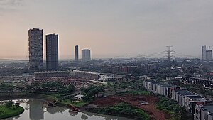
Tangerang
City in Java, Indonesia
Distance: Approx. 3553 meters
Latitude and longitude: -6.17027778,106.64027778
Tangerang (Sundanese: ᮒᮍᮨᮛᮀ, Indonesian pronunciation: [taˈŋəɾaŋ]) is the city with the largest population in the province of Banten, Indonesia. Located on the western border of Jakarta, it is the sixth largest city proper in the nation (excluding Jakarta, which is classed as a province containing five administrative cities and one regency). It has an area of 164.55 km2 (63.53 sq mi) and an official 2010 Census population of 1,798,601, which had risen to 1,895,486 at the 2020 Census – making it the eighth most populated suburb in the world at the latter date; the official estimate as at mid 2023 was 1,912,679 - comprising 961,354 males and 951,325 females.

Lippo Village International Formula Circuit
Defunct street circuit in Lippo Village Tangerang, Indonesia
Distance: Approx. 4695 meters
Latitude and longitude: -6.22905556,106.60863889
The Lippo Village International Formula Circuit is a defunct street circuit in Lippo Village Tangerang, Indonesia. The track was confirmed to host a round of the 2008–09 A1 Grand Prix season, set for the weekend of February 8, 2009. On August 29, 2008, further details regarding the track were announced.

Swiss German University
Sponsored university
Distance: Approx. 6314 meters
Latitude and longitude: -6.22552222,106.65496944
Swiss German University (SGU) is a privately sponsored university and located at Alam Sutera, a community in Tangerang, Banten, Indonesia. Swiss German University was established in the year 2000 as a joint effort between private investors from Germany and Indonesia. Nowadays, it is run by an Indonesian businessman.
Sekolah Menengah Atas Kristen Penabur Gading Serpong
Private school in Tangerang, Banten, Indonesia
Distance: Approx. 5574 meters
Latitude and longitude: -6.23530556,106.62661111
Sekolah Menengah Atas Kristen PENABUR Gading Serpong, often shortened to SMAK PENABUR Gading Serpong (or AGS), is a Christian private high school located in Gading Serpong, Tangerang, Banten, Indonesia. It is organized by the BPK PENABUR Jakarta Foundation. The school provides tenth to twelfth grade programs as implemented nationally in Indonesia.
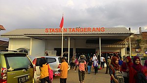
Tangerang railway station
Railway station in Indonesia
Distance: Approx. 2488 meters
Latitude and longitude: -6.1769,106.633
Tangerang Station (Indonesian: Stasiun Tangerang) is a railway station located in the city of Tangerang, Banten. It is the western terminus of the Duri–Tangerang railway. This station only serves commuter trains operated by Kereta Commuter Indonesia.

Pelita Harapan University
Private university in Indonesia
Distance: Approx. 4693 meters
Latitude and longitude: -6.2292,106.6108
Pelita Harapan University (Indonesian: Universitas Pelita Harapan, UPH) is a private Reformed Evangelical coeducational higher education institution run by the Pelita Harapan Education Foundation (Indonesian: Yayasan Pendidikan Pelita Harapan) in Lippo Village, Tangerang, Banten, Indonesia. It was founded in 1993 and is part of the Lippo Group. UPH was the first university in Indonesia to introduce programs entirely taught in English, the first to offer a liberal arts curriculum, and the first to introduce a multi-disciplinary approach to its programs.

Benteng Heritage Museum
Museum in Banten, Indonesia
Distance: Approx. 2069 meters
Latitude and longitude: -6.1786869,106.6296684
The Benteng Heritage Museum (Indonesian: Museum Benteng Heritage) is a heritage site and museum in Pasar Lama, the old market district in Tangerang, Banten, Indonesia. Located near the river Cisadane, it is the first Indonesian museum that highlights the history and heritage of ethnic Chinese in Indonesia. Benteng Heritage Museum is housed in a traditional, vernacular Peranakan Chinese building.

Kali Pasir Mosque
Mosque in Tangerang, Banten, Indonesia
Distance: Approx. 1962 meters
Latitude and longitude: -6.17922222,106.62886111
The Kali Pasir Mosque (Indonesian: Masjid Kali Pasir) is the oldest mosque in Tangerang city, a relic of Pajajaran Kingdom. It is located in Cisadane riverbank, in the middle of Chinese residential and is characterized by it Chinese pattern.

Gading Serpong
City in West Jakarta, Indonesia
Distance: Approx. 6470 meters
Latitude and longitude: -6.243,106.629
Gading Serpong is a planned township, 21 km west of Jakarta at Kelapa Dua and Pagedangan, Tangerang Regency of Banten province in Indonesia. Since the township is co-developed, Gading Serpong consists of two main area, Summarecon Serpong (for area developed by PT Summarecon Agung Tbk) and Paramount Serpong (for area developed by PT Paramount Enterprise International or Paramount Land). However, it is often still refereed as Gading Serpong or shortened to GS. With total area of 1,500 hectares, Gading Serpong is one of the elite planned satellite cities in Western Greater Jakarta (South Tangerang and Tangerang Regency), adjacent to Lippo Karawaci to the west, BSD City to the south, and Alam Sutera to the east.
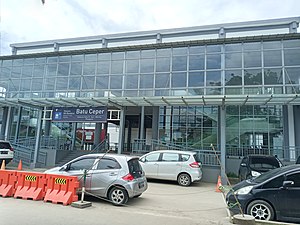
Batu Ceper railway station
Railway station in Indonesia
Distance: Approx. 5999 meters
Latitude and longitude: -6.172205,106.665093
Batu Ceper Station (BPR) (Indonesian: Stasiun Batu Ceper) is a railway station located at Poris Plawad, Cipondoh, Tangerang, Indonesia. Although named as Batu Ceper, but the location of this station is not in the district of Batuceper, rather it is located at Cipondoh district of Tangerang. The station serves Greater Jakarta commuter rail and Soekarno–Hatta Airport Rail Link.

Al-Azhom Grand Mosque
Mosque in Tangerang, Banten, Indonesia
Distance: Approx. 3461 meters
Latitude and longitude: -6.16984276,106.6390134
Al-Azhom Grand Mosque (Indonesian: Masjid Raya Al-A'zhom) is a congregational mosque in the city of Tangerang, Banten, Indonesia. Opened in 2003, it is the largest mosque in Banten province and one of the largest mosques in the world in terms of the worshipper capacity.
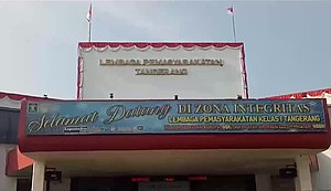
Tangerang prison fire
2021 fire near Jakarta, Indonesia
Distance: Approx. 3019 meters
Latitude and longitude: -6.18666667,106.64027778
On 8 September 2021, a fire occurred in an overcrowded prison block in the city of Tangerang, Banten, Indonesia, in Greater Jakarta. The fire began at about 01:45 WIB (18:45 UTC, 7 September) in sector C of the Tangerang prison, killing 41 inmates and injuring a further 75. More victims succumbed to their injuries in the following days, raising the death toll to 49.
Weather in this IP's area
few clouds
30 Celsius
32 Celsius
29 Celsius
32 Celsius
1014 hPa
57 %
1014 hPa
1012 hPa
9000 meters
3.6 m/s
220 degree
20 %
05:30:13
17:46:07