103.134.138.48 - IP Lookup: Free IP Address Lookup, Postal Code Lookup, IP Location Lookup, IP ASN, Public IP
Country:
Region:
City:
Location:
Time Zone:
Postal Code:
ISP:
ASN:
language:
User-Agent:
Proxy IP:
Blacklist:
IP information under different IP Channel
ip-api
Country
Region
City
ASN
Time Zone
ISP
Blacklist
Proxy
Latitude
Longitude
Postal
Route
db-ip
Country
Region
City
ASN
Time Zone
ISP
Blacklist
Proxy
Latitude
Longitude
Postal
Route
IPinfo
Country
Region
City
ASN
Time Zone
ISP
Blacklist
Proxy
Latitude
Longitude
Postal
Route
IP2Location
103.134.138.48Country
Region
pennsylvania
City
springs
Time Zone
America/New_York
ISP
Language
User-Agent
Latitude
Longitude
Postal
ipdata
Country
Region
City
ASN
Time Zone
ISP
Blacklist
Proxy
Latitude
Longitude
Postal
Route
Popular places and events near this IP address

Grantsville, Maryland
Town in Maryland, United States
Distance: Approx. 7081 meters
Latitude and longitude: 39.69694444,-79.15277778
Grantsville is a town in the northern part of Garrett County, Maryland, United States, near the Pennsylvania border. The population was 968 as of the 2020 census.

Elk Lick Township, Pennsylvania
Township in Pennsylvania, United States
Distance: Approx. 6237 meters
Latitude and longitude: 39.73333333,-79.16638889
Elk Lick Township is a township in Somerset County, Pennsylvania, United States. The population was 2,264 at the 2020 census. Mount Davis, the highest point in Pennsylvania, is located within the township.
Springs, Pennsylvania
Unincorporated community in Pennsylvania, U.S.
Distance: Approx. 4780 meters
Latitude and longitude: 39.73361111,-79.14916667
Springs is an unincorporated community in Elk Lick Township, Somerset County, Pennsylvania, United States. Springs is known for its Spring Folk Festival, which takes place annually in October, its museum and its farmers' market. It is part of the Johnstown, Pennsylvania Metropolitan Statistical Area.

Casselman Bridge
State park in Maryland, United States
Distance: Approx. 6574 meters
Latitude and longitude: 39.69666667,-79.14361111
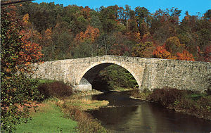
The Casselman Bridge is a historic transportation structure on the Casselman River, located immediately east of Grantsville in Garrett County, Maryland, and preserved by the state of Maryland as Casselman River Bridge State Park. The bridge was built in 1813–1814 as part of the National Road. Historic markers posted at each end read: Erected 1813 by David Shriver Jr.,Sup't of the "Cumberland Road" (The National Road).
Little Meadows, Maryland
Distance: Approx. 4769 meters
Latitude and longitude: 39.69916667,-79.09333333
Little Meadows is located at the foot of Meadow Mountain in western Maryland. It was a common stopping point for British troops during the French and Indian War and was frequented by George Washington.

Stanton's Mill
Historic district in Maryland, United States
Distance: Approx. 6430 meters
Latitude and longitude: 39.69611111,-79.14
Stanton's Mill is a historic grist mill complex located at Grantsville, Garrett County, Maryland, consisting of five interrelated buildings and structures. The Stanton's Mill building dates from about 1797. It is two stories and constructed of heavy timber frame with a gable roof; an addition was constructed in 1890.
Meyersdale Area High School
School in Meyersdale, Pennsylvania
Distance: Approx. 7487 meters
Latitude and longitude: 39.79739,-79.04476
Meyersdale Area High School is a four-year high school, located just south of Meyersdale in southcentral Somerset County in Summit Township. The original complex was opened in the late 1950s and featured modern classrooms, a gymnasium, auditorium, cafeteria, library, commercial shops and adjoining athletic fields.
Salisbury-Elk Lick Junior/Senior High School
School in Salisbury, Pennsylvania
Distance: Approx. 1572 meters
Latitude and longitude: 39.75305,-79.08296
Salisbury-Elk Lick Junior/Senior High School is a public secondary school, located only two miles north of the Mason–Dixon line in the small town of Salisbury, Somerset County, Pennsylvania. The Junior - Senior High School was built in 1954, at a cost of $550,000.00. Students first occupied the building on January 21, 1955.

Buckel's Bog
Distance: Approx. 6371 meters
Latitude and longitude: 39.69888889,-79.14333333
Buckel's Bog was a 160-acre, shallow periglacial lake or a glade that occupied the headwater region of the North Branch of the Casselman River in Garrett County, Maryland, during the late Pleistocene epoch. It is the remnant of the only known natural lake in Maryland. The eastern side of the remaining evidence of Buckel's Bog is presently traversed by the Casselman River as its waters flow northward into Pennsylvania.
West Salisbury, Pennsylvania
Unincorporated community in Pennsylvania, United States
Distance: Approx. 1355 meters
Latitude and longitude: 39.75416667,-79.095
West Salisbury is an unincorporated community in Somerset County, Pennsylvania, United States. The community is located along Pennsylvania Route 669 on the western border of Salisbury. West Salisbury had a post office from March 10, 1900, until July 23, 2011; it still has its own ZIP code, 15565.

Boynton, Pennsylvania
Unincorporated community in Pennsylvania, United States
Distance: Approx. 3629 meters
Latitude and longitude: 39.76666667,-79.06666667
Boynton is an unincorporated community in Somerset County, Pennsylvania, United States. The community is located along the Casselman River and U.S. Route 219, 1.2 miles (1.9 km) north-northeast of Salisbury. Boynton has a post office, with ZIP code 15532.

Spruce Forest Artisan Village
Heritage center in Garrett County, Maryland
Distance: Approx. 6492 meters
Latitude and longitude: 39.6965,-79.14183333
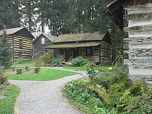
The Spruce Forest Artisan Village is an arts and heritage center in Garrett County, Maryland, that is dedicated to preserving the heritage of the region. Resident and visiting artisans demonstrate their crafts in restored log cabins and vintage frame structures. Artisan crafts include blacksmithing, weaving, wheel-thrown pottery, bird sculpting, woodturning, and jewelry-smithing.
Weather in this IP's area
scattered clouds
-9 Celsius
-16 Celsius
-10 Celsius
-6 Celsius
1022 hPa
91 %
1022 hPa
928 hPa
10000 meters
4.67 m/s
13.76 m/s
266 degree
26 %