Country:
Region:
City:
Latitude and Longitude:
Time Zone:
Postal Code:
IP information under different IP Channel
ip-api
Country
Region
City
ASN
Time Zone
ISP
Blacklist
Proxy
Latitude
Longitude
Postal
Route
Luminati
Country
ASN
Time Zone
Asia/Singapore
ISP
NEC ASIA PACIFIC PTE LTD
Latitude
Longitude
Postal
IPinfo
Country
Region
City
ASN
Time Zone
ISP
Blacklist
Proxy
Latitude
Longitude
Postal
Route
db-ip
Country
Region
City
ASN
Time Zone
ISP
Blacklist
Proxy
Latitude
Longitude
Postal
Route
ipdata
Country
Region
City
ASN
Time Zone
ISP
Blacklist
Proxy
Latitude
Longitude
Postal
Route
Popular places and events near this IP address

Kallang
Planning Area and HDB Town in Central Region, Singapore
Distance: Approx. 741 meters
Latitude and longitude: 1.31083333,103.86555556
Kallang is a planning area and residential zone located in the Central Region of Singapore. Development of the town is centered around the Kallang River, the longest river in Singapore. Kallang Planning Area is bounded by Toa Payoh in the north, Geylang in the east, Marine Parade in the southeast, Marina East in the south, the Downtown Core in the southwest, Rochor, Newton in the west, and Novena in the northwest.

Boon Keng MRT station
Mass Rapid Transit station in Singapore
Distance: Approx. 350 meters
Latitude and longitude: 1.319483,103.861722
Boon Keng MRT station is an underground Mass Rapid Transit (MRT) station on the North East line in Kallang, Singapore. Located underneath Serangoon Road just after the traffic junction with Towner Road and Boon Keng Road, Boon Keng station primarily serves the Boon Keng subzone and more importantly the residents residing in the area. Other than the HDB dwellers, residents of condos such as Eight Riversuites, Regent Residences and The Arcady at Boon Keng also benefited greatly from the convenience.

CNA938
Radio station
Distance: Approx. 554 meters
Latitude and longitude: 1.312751,103.862
CNA938 is an English-language radio station in Singapore. Owned by the state-owned broadcaster Mediacorp and launched on 2 October 1998, it broadcasts a news/talk radio format. The station is marketed as a radio extension of Mediacorp's television channel CNA, broadcasting news and lifestyle programmes from 7 a.m.

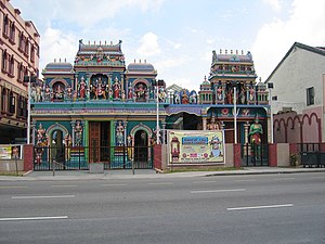
Sri Vadapathira Kaliamman Temple
Hindu temple in Singapore
Distance: Approx. 700 meters
Latitude and longitude: 1.31543056,103.858
The Sri Vadapathira Kaliamman Temple is a Hindu temple located in Little India in Singapore.
Central Sikh Temple
Gurdwara in Singapore
Distance: Approx. 595 meters
Latitude and longitude: 1.3166,103.8587
Central Sikh Temple is the first Sikh gurdwara in Singapore. Established in 1912, the temple had relocated several times before moving to its current site at Towner Road at the junction of Serangoon Road in Kallang in 1986 near Boon Keng MRT station.

Bendemeer MRT station
Mass Rapid Transit station in Singapore
Distance: Approx. 427 meters
Latitude and longitude: 1.3135953,103.8630402
Bendemeer MRT station is an underground Mass Rapid Transit (MRT) station on the Downtown line in Kallang, Singapore. Despite its name, the station is not located under Bendemeer Road, but under Kallang Bahru. This station serves the commercial developments around Lavender Street and the industrial estates along Kallang Avenue.
Kallang Bahru
Subzone of Kallang Planning Area in Central Region, Singapore
Distance: Approx. 79 meters
Latitude and longitude: 1.3179,103.8644
Kallang Bahru is a subzone within the planning area of Kallang, Singapore, as defined by the Urban Redevelopment Authority (URA). This subzone is bounded by Bendemeer Road and Sungei Whampoa in the north; the Kallang River in the east; Kallang Road and Sims Avenue in the south; and Lavender Street in the west. "Kallang Bahru" is also the name of a two-way road in the area.
Bendemeer, Singapore
Subzone of Kallang Planning Area in Central Region, Singapore
Distance: Approx. 371 meters
Latitude and longitude: 1.32046944,103.86507222
Bendemeer (Chinese: 明地迷亚, Tamil: பென்ட்டிமியிர்) is a subzone within the planning area of Kallang, Singapore, as defined by the Urban Redevelopment Authority (URA). Its boundary is made up of the Pan Island Expressway (PIE) in the north; Serangoon Road, the Kallang River, Sungei Whampoa and Bendemeer Road in the east; Lavender Street and Balestier Road in the south; and the Central Expressway (CTE) in the west. Bendemeer is primarily residential, consisting of both public housing built by the Housing and Development Board (HDB) and private housing.
Umar Pulavar Tamil Language Centre
Distance: Approx. 627 meters
Latitude and longitude: 1.3142,103.8593
Umar Pulavar Tamil Language Centre, formerly known as St George’s Road Tamil Language Centre, is an academic institution for teaching Tamil language in Singapore. The institution is named after famed Tamil poet Umaru Pulavar. After the closure of Umar Pulavar Tamil High School in 1982, St George’s Road Tamil Language Centre was renamed as Umar Pulavar Tamil Language Centre in 1983 to preserve the name of the high school.
34 Whampoa West
Distance: Approx. 472 meters
Latitude and longitude: 1.3205,103.8612
Block 34 Whampoa West is an HDB block in Bendemeer, Singapore. The block is the third longest surviving HDB block, behind 121 Paya Lebar Way and 195 Kim Keat Avenue, being 311.5 metres long.
593 Serangoon Road
Distance: Approx. 623 meters
Latitude and longitude: 1.31607,103.85854
593 Serangoon Road is a shophouse on the corner of Serangoon Road and Balestier Road. It previously housed the Singapore Institute of Science and currently houses the Sin Peng Lounge.
161 Lavender Street
Shophouses in Kallang, Singapore
Distance: Approx. 601 meters
Latitude and longitude: 1.31287,103.86092
161 Lavender Street is a row of shophouses on Lavender Street in the Lavender subzone of Kallang, Singapore. Completed by philanthropist Lee Kong Chian in the 1930s, it was gazetted for conservation as part of the Jalan Besar Secondary Settlement conservation area.
Weather in this IP's area
light rain
29 Celsius
35 Celsius
28 Celsius
30 Celsius
1010 hPa
76 %
1010 hPa
1009 hPa
10000 meters
1.03 m/s
75 %
06:47:31
18:51:00
