103.129.77.120 - IP Lookup: Free IP Address Lookup, Postal Code Lookup, IP Location Lookup, IP ASN, Public IP
Country:
 Myanmar (Burma)
Region:
City:
Location:
Time Zone:
Postal Code:
ISP:
ASN:
language:
User-Agent:
Proxy IP:
Blacklist:
IP information under different IP Channel
ip-api
Country
Region
City
ASN
Time Zone
ISP
Blacklist
Proxy
Latitude
Longitude
Postal
Route
db-ip
Country
Region
City
ASN
Time Zone
ISP
Blacklist
Proxy
Latitude
Longitude
Postal
Route
IPinfo
Country
Region
City
ASN
Time Zone
ISP
Blacklist
Proxy
Latitude
Longitude
Postal
Route
IP2Location
103.129.77.120Country
mmRegion
shan
City
tachilek
Time Zone
Asia/Rangoon
ISP
Language
User-Agent
Latitude
Longitude
Postal
ipdata
Country
Region
City
ASN
Time Zone
ISP
Blacklist
Proxy
Latitude
Longitude
Postal
Route
Popular places and events near this IP address

Mae Sai district
District of Thailand
Distance: Approx. 2443 meters
Latitude and longitude: 20.42805556,99.88361111
Mae Sai (Thai: แม่สาย, pronounced [mɛ̂ː sǎːj]; Shan: မႄႈသၢႆ, pronounced [mɛ.sʰǎj]) is the northernmost district (amphoe) of Chiang Rai province in northern Thailand. The town of Mae Sai is a major border crossing between Thailand and Myanmar. Asian Highway Network AH2 (Thailand Route 1 or Phahonyothin Road) crosses the Mae Sai River to the town Tachileik in Myanmar.

Tachileik Township
Township in Shan State, Burma
Distance: Approx. 873 meters
Latitude and longitude: 20.45,99.89166667
Tachileik Township is a township of Tachileik District in the Shan State of Myanmar. The principal town is Tachileik.

Tachileik
Town in Shan State, Myanmar
Distance: Approx. 1343 meters
Latitude and longitude: 20.45277778,99.89583333
Tachileik (also spelt Tachilek; Burmese: တာချီလိတ်, [tà tɕʰì leɪʔ]; Shan: တႃႈၶီႈလဵၵ်း, [tɑ᷆.kʰi᷆.lék]; Thai: ท่าขี้เหล็ก, RTGS: Tha Khilek, [tʰâː.kʰîː.lèk]) is a border town in Shan State of eastern Myanmar. It is the administrative seat of Tachileik Township and Tachileik District and most populated city in eastern Shan State with 51,553 residents per 2014 census count, ahead of Kyaing Tong, but only 4th statewide. It faces Mae Sai in Thailand, and is home to one of Myanmar's seven official border trade posts with Thailand.

Sai River (Thailand)
River in Myanmar and Thailand
Distance: Approx. 7621 meters
Latitude and longitude: 20.46444444,99.95472222
Sai River (Thai: แม่สาย or แม่น้ำสาย; RTGS: Mae Sai or Maenam Sai; Thai pronunciation: [mɛ̂ː.sǎːj / mɛ̂ː.náːm.sǎːj]), formerly known as the River of Lawa (Thai: แม่ละว้า; RTGS: Mae Lawa), is a river that forms the natural border between Thailand and Myanmar at Tachileik and Mae Sai Districts. Mae Sai town, where the bridge crossing the international border is located, is named after this river. It is a tributary of the Ruak River, itself a tributary of the Mekong.

Ko Chang, Chiang Rai
Tambon in Thailand
Distance: Approx. 8892 meters
Latitude and longitude: 20.43333333,99.96666667
Ko Chang, Chiang Rai (Thai: เกาะช้าง) is a village and tambon (sub-district) of Mae Sai District, in Chiang Rai Province, Thailand. In 2005, it had a population of 9,964 people. The tambon contains 13 villages.
Wiang Phang Kham
Subdistrict in Thailand
Distance: Approx. 4149 meters
Latitude and longitude: 20.41277778,99.88527778
Wiang Phang Kham (Thai: เวียงพางคำ) is a subdistrict (tambon) of Mae Sai District, in Chiang Rai Province, Thailand. In 2012 it had a population of 20,252 people.

Mae Sai
Subdistrict Municipality in Chiang Rai Province, Thailand
Distance: Approx. 2443 meters
Latitude and longitude: 20.42805556,99.88361111
Mae Sai (Thai: แม่สาย, pronounced [mɛ̂ː sǎːj]; Shan: မႄႈသၢႆ, pronounced [mɛ.sʰǎj]), is the district town of Mae Sai District in the far north of Chiang Rai Province, Thailand. Mae Sai is a major border crossing between Thailand and Myanmar; the town of Tachileik, in Shan State is across the bridge. Asian Highway Network AH2 (Thailand Route 1 or Phahonyothin Road) crosses the Mae Sai River to the town of Tachileik in Myanmar .
Mae Sai, Phayao
Tambon in Thailand
Distance: Approx. 1855 meters
Latitude and longitude: 20.43333333,99.88333333
Mae Sai (Thai: แม่ใส, pronounced [mɛ̂ː sǎj]) is a village and tambon (subdistrict) of Mueang Phayao District, in Phayao Province, Thailand. In 2005 it had a total population of 6451 people.
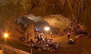
Tham Luang cave rescue
2018 international rescue in Thailand
Distance: Approx. 7765 meters
Latitude and longitude: 20.38166667,99.86833333
In June and July 2018, a junior association football team became trapped in Tham Luang Nang Non, a cave system in Chiang Rai province, northern Thailand, but were ultimately rescued. Twelve members of the team, aged 11 to 16, and their 25-year-old assistant coach entered the cave on 23 June after a practice session. Shortly after they entered, heavy rainfall began and partially flooded the cave system, blocking their way out and trapping them deep within.
Tham Luang Nang Non
Cave in Chiang Rai province, Thailand
Distance: Approx. 7765 meters
Latitude and longitude: 20.38166667,99.86833333
Tham Luang Nang Non (Thai: ถ้ำหลวงนางนอน, lit. 'Great Cave of the Sleeping Lady', RTGS: Tham Luang Nang Non, pronounced [tʰâm lǔaŋ nāːŋ nɔ̄ːn]) Also known as Tham Luang, and Tham Yai is a karstic cave system in the Tham Luang–Khun Nam Nang Non Forest Park, near the village of Ban Chong in Pong Pha subdistrict, in northern Thailand. It lies beneath Doi Nang Non, a mountain range on the border with Myanmar. Initially just known to locals, Tham Luang Cave gained to international fame during a significant rescue mission on July 2, 2018.
Weather in this IP's area
few clouds
24 Celsius
24 Celsius
24 Celsius
24 Celsius
1006 hPa
48 %
1006 hPa
931 hPa
10000 meters
0.74 m/s
1.02 m/s
149 degree
16 %