Country:
 Pakistan
Region:
City:
Latitude and Longitude:
Time Zone:
Postal Code:
IP information under different IP Channel
ip-api
Country
Region
City
ASN
Time Zone
ISP
Blacklist
Proxy
Latitude
Longitude
Postal
Route
IPinfo
Country
Region
City
ASN
Time Zone
ISP
Blacklist
Proxy
Latitude
Longitude
Postal
Route
MaxMind
Country
Region
City
ASN
Time Zone
ISP
Blacklist
Proxy
Latitude
Longitude
Postal
Route
Luminati
Country
PKRegion
sd
City
hyderabad
ASN
Time Zone
Asia/Karachi
ISP
Ebone Network PVT. Limited
Latitude
Longitude
Postal
db-ip
Country
Region
City
ASN
Time Zone
ISP
Blacklist
Proxy
Latitude
Longitude
Postal
Route
ipdata
Country
Region
City
ASN
Time Zone
ISP
Blacklist
Proxy
Latitude
Longitude
Postal
Route
Popular places and events near this IP address

Hyderabad, Sindh
Metropolitan area in Sindh
Distance: Approx. 3507 meters
Latitude and longitude: 25.37916667,68.36833333
Hyderabad (Sindhi: حيدرآباد; Urdu: حيدرآباد; ) is a city and the capital of Hyderabad Division in the Sindh province of Pakistan. It is the second-largest city in Sindh, and the fifth largest in Pakistan. Founded in 1768 by Mian Ghulam Shah Kalhoro of the Kalhora Dynasty, Hyderabad served as a provincial capital until the British transferred the capital to Bombay Presidency in 1840.
Hyderabad Airport (Sindh)
Airport
Distance: Approx. 3842 meters
Latitude and longitude: 25.31833333,68.36666667
The Hyderabad Airport (IATA: HDD, ICAO: OPKD) is a domestic airport in Hyderabad, Sindh, Pakistan. It is very close to the Pakistan Army's Sindh Regimental Centre and the HDA Kohsar Housing Society. The airport has been closed to commercial traffic as of 2013.
Niaz Stadium
Cricket ground in Hyderabad, Pakistan
Distance: Approx. 3870 meters
Latitude and longitude: 25.3826,68.3381
Niaz Stadium is a cricket ground in Hyderabad, Pakistan. The ground can accommodate 15,000 spectators, and hosted its first Test match in 1973. It was established in November 1961 by the then Commissioner of Hyderabad, Niaz Ahmed, after whom the stadium is named.

Hyderabad City Tehsil
Tehsil in Sindh, Pakistan
Distance: Approx. 3509 meters
Latitude and longitude: 25.3792,68.3683
Hyderabad City Tehsil (Sindhi : حيدرآباد شھر تعلقو) is an administrative subdivision (tehsil) of Hyderabad District in the Sindh province of Pakistan. Hyderabad district is subdivided into 4 talukas, the Urban area around the capital Hyderabad is part of Hyderabad City Taluka.

Rani Bagh, Hyderabad
Zoo in Hyderabad, Pakistan
Distance: Approx. 3661 meters
Latitude and longitude: 25.38223,68.34305
The Rani Bagh (Sindhi: راڻي باغ, lit. 'Queen's Garden'), previously known as Das Garden, is a zoological garden located in Hyderabad, Sindh, Pakistan. The garden was re-christened in honour of Queen Victoria. It was established as a botanical garden in 1861 by the then Agro-horticultural Society and later animals were moved in.

Pacco Qillo
18 century fort Hyderabad, Sindh
Distance: Approx. 4227 meters
Latitude and longitude: 25.38443889,68.37268611
Pakko Qillo (Sindhi: پڪو قلعو, Strong Fort) is a fort in Hyderabad, Sindh, Pakistan. It was built in the 18th century, and served as a strategic military base and played a crucial role in the city's history.

Sindh Museum
Archaeology museum in Sindh, Pakistan
Distance: Approx. 4106 meters
Latitude and longitude: 25.3848315,68.3379352
The Sindh Museum (Urdu: سندھ میوزیم) is a museum located in Hyderabad, Sindh, Pakistan. The museum was established in 1971 to collect, preserve, study, and exhibit the records of the cultural history of Sindh. It also sometimes hosts cultural fairs.
Climate of Hyderabad, Sindh
Distance: Approx. 3507 meters
Latitude and longitude: 25.37916667,68.36833333
The climate of Hyderabad is semi-arid, featuring too little rain to feature the tropical savanna climate. The days are hot and dry, usually going up to extreme highs of 40 °C (104 °F), while the nights are cool and breezy. Winds usually bring along clouds of dust, and people prefer staying indoors in the daytime, while the breezes at night are pleasant and clean.
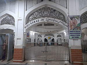
Hyderabad Junction railway station
Railway station in Sindh, Pakistan
Distance: Approx. 3942 meters
Latitude and longitude: 25.3811,68.37349892
Hyderabad Junction Railway Station (Sindhi: حيدرآباد جنڪشن ريلوي اسٽيشن) is located in the city of Hyderabad, Sindh, Pakistan and serves as a major railway junction.
Cowasjee Jehangir Institute of Psychiatry
Hospital in Sindh, Pakistan
Distance: Approx. 3632 meters
Latitude and longitude: 25.377219,68.332365
Jehangir Institute of Psychiatry is a hospital located in Latifabad suburb of the city of Hyderabad, in Sindh, Pakistan. It was established in 1852 during the British Raj and was named after Jehangir Cowasji Jehangir Readymoney. It is the largest psychiatric hospital in Pakistan.

Mukhi House
Museum in Hyderabad, Sindh, Pakistan
Distance: Approx. 4322 meters
Latitude and longitude: 25.3862,68.3708
The Mukhi House, also known as Mukhi Mahal, is a museum located in Hyderabad, Sindh, Pakistan. For a brief period, it housed a government school named Khadija Girls School.

Hasrat Mohani Library
Public library in Hyderabad, Pakistan
Distance: Approx. 4300 meters
Latitude and longitude: 25.385722,68.371441
Hasrat Mohani Library, also known as Hasrat Mohani District Central Library, Hyderabad, and formerly known as Holm Stead Free Readers Hall, (Urdu: حسرت موہانی لائبریری) is a public library located in Hyderabad, Sindh, Pakistan, adjacent to Pacco Qillo. It is the oldest library in the city of Hyderabad.
Weather in this IP's area
clear sky
36 Celsius
35 Celsius
36 Celsius
36 Celsius
1011 hPa
29 %
1011 hPa
1009 hPa
10000 meters
0.89 m/s
0.88 m/s
115 degree
4 %
06:26:55
17:55:49