103.127.98.14 - IP Lookup: Free IP Address Lookup, Postal Code Lookup, IP Location Lookup, IP ASN, Public IP
Country:
Region:
City:
Location:
Time Zone:
Postal Code:
IP information under different IP Channel
ip-api
Country
Region
City
ASN
Time Zone
ISP
Blacklist
Proxy
Latitude
Longitude
Postal
Route
Luminati
Country
ASN
Time Zone
Asia/Jakarta
ISP
PT Biznet Gio Nusantara
Latitude
Longitude
Postal
IPinfo
Country
Region
City
ASN
Time Zone
ISP
Blacklist
Proxy
Latitude
Longitude
Postal
Route
IP2Location
103.127.98.14Country
Region
jawa barat
City
padalarang
Time Zone
Asia/Jakarta
ISP
Language
User-Agent
Latitude
Longitude
Postal
db-ip
Country
Region
City
ASN
Time Zone
ISP
Blacklist
Proxy
Latitude
Longitude
Postal
Route
ipdata
Country
Region
City
ASN
Time Zone
ISP
Blacklist
Proxy
Latitude
Longitude
Postal
Route
Popular places and events near this IP address

Cimahi
City in Java, Indonesia
Distance: Approx. 9796 meters
Latitude and longitude: -6.8712,107.5548
Cimahi (Indonesian pronunciation: [tʃimahi]) is a landlocked city located immediately west of the larger city of Bandung, in West Java Province, Indonesia and within the Bandung Metropolitan Area. It covers an area of 42.43 km2 and had a population at the 2010 Census of 541,177 and at the 2020 Census of 568,400; the official estimate as at mid 2023 was 590,782 (comprising 297,844 males and 292,938 females). The city is a major textile producer, and is home to several military training centres.
Padalarang–Cileunyi Toll Road
Toll Road in Indonesia
Distance: Approx. 4302 meters
Latitude and longitude: -6.85957778,107.50495833
Padalarang–Cileunyi Toll Road or Padaleunyi is an expressway located in Bandung, West Java. It is a part of the Purbaleunyi Toll Road (Purwakarta-Bandung-Cileunyi) connecting Cileunyi, Bandung Regency with Purwakarta and onwards to Jakarta. This particular segment of the toll road bypasses the city of Bandung and is also used for local transportation between locations passed.

West Bandung Regency
Regency in West Java, Indonesia
Distance: Approx. 4325 meters
Latitude and longitude: -6.8393,107.5119
West Bandung Regency (Kabupaten Bandung Barat) is a landlocked regency of West Java. It was established on 2 January 2007, having been formerly part of Bandung Regency. The capital of this new regency is Ngamprah, an industrial district on the west side of Bandung.
Bandung Alliance Intercultural School
Distance: Approx. 3514 meters
Latitude and longitude: -6.8687102,107.4663402
Bandung Alliance Intercultural School (BAIS) is in Kota Baru Parahyangan, a development on the outskirts of Bandung, Indonesia. It has been a member of the Network of International Christian Schools since 1995. Fully accredited through WASC and ACSI, BAIS is a private, non-profit school primarily serving the international community of Bandung.

Padalarang, West Bandung
District in West Bandung Regency, Indonesia
Distance: Approx. 849 meters
Latitude and longitude: -6.8435,107.4779
Padalarang is a district in West Bandung Regency, West Java Province, Indonesia.

Ngamprah
District in West Java, Indonesia
Distance: Approx. 2750 meters
Latitude and longitude: -6.82916667,107.49611111
Ngamprah (ᮌᮙ᮪ᮕᮢᮂ) is a kecamatan (district) in central Parahyangan region of Java, which serves as the regency seat of West Bandung Regency in West Java, Indonesia. Ngamprah has postal code 40552 that applies to all 11 villages located in Ngamprah.

Gadobangkong railway station
Railway station in Indonesia
Distance: Approx. 5568 meters
Latitude and longitude: -6.864811,107.515203
Gadobangkong Station (GK) is a railway station located in Gadobangkong, Ngamprah, West Bandung Regency. The station, which is located at an altitude of +695 meters (previously +713 m), is included in the Operational Area II Bandung. The station is located not far from Jl.

Cimahi railway station
Railway station in Indonesia
Distance: Approx. 8796 meters
Latitude and longitude: -6.88583,107.536
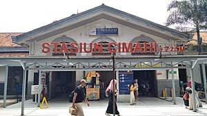
Cimahi Station (CMI) (Sundanese: ᮞ᮪ᮒᮞᮤᮇᮔ᮪ ᮎᮤᮙᮠᮤ, romanized: Stasion Cimahi) is a class II railway station located in Baros, Padalarang, West Bandung Regency, to be precise on Station Street, Bandung Barat. The station, which is located at an altitude of +723 meters, is included in the Operational Area II Bandung.

Cipatat railway station
Railway station in Indonesia
Distance: Approx. 9753 meters
Latitude and longitude: -6.822008,107.386004
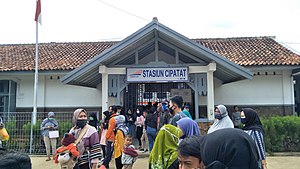
Cipatat railway station (Indonesian: Stasiun Cipatat) is a class III railway station located at Cipatat, Cipatat, West Bandung Regency, West Java, Indonesia. The station, which is located at an altitude of +387 m, is included in the Operation Area II Bandung. The station reopened on 21 September 2020, as part of the continuing rehabilitation of the Manggarai–Padalarang line.

Leuwigajah War Cemetery
Dutch war cemetery in Cimahi, Indonesia
Distance: Approx. 9789 meters
Latitude and longitude: -6.90559,107.52922
Leuwigajah War Cemetery, also Dutch Field of Honor Leuwigajah (Dutch: Nederlands Ereveld Leuwigajah, Indonesian: Makam Kehormatan Belanda di Leuwigajah), is a war cemetery just outside of Cimahi, West Java, in Indonesia.
Weather in this IP's area
overcast clouds
26 Celsius
26 Celsius
26 Celsius
27 Celsius
1009 hPa
89 %
1009 hPa
924 hPa
5647 meters
1.19 m/s
1.71 m/s
298 degree
100 %