Country:
Region:
City:
Latitude and Longitude:
Time Zone:
Postal Code:
IP information under different IP Channel
ip-api
Country
Region
City
ASN
Time Zone
ISP
Blacklist
Proxy
Latitude
Longitude
Postal
Route
Luminati
Country
Region
ji
City
sidoarjo
ASN
Time Zone
Asia/Jakarta
ISP
PT. Eka Mas Republik
Latitude
Longitude
Postal
IPinfo
Country
Region
City
ASN
Time Zone
ISP
Blacklist
Proxy
Latitude
Longitude
Postal
Route
db-ip
Country
Region
City
ASN
Time Zone
ISP
Blacklist
Proxy
Latitude
Longitude
Postal
Route
ipdata
Country
Region
City
ASN
Time Zone
ISP
Blacklist
Proxy
Latitude
Longitude
Postal
Route
Popular places and events near this IP address

Jatinegara railway station
Railway station in Indonesia
Distance: Approx. 1562 meters
Latitude and longitude: -6.215,106.87027778
Jatinegara Station (JNG) is a large type A-class railway station located on the border between Jatinegara and Matraman in Pisangan Baru Subdistrict, Matraman, East Jakarta. The station is the main entrance to Jakarta from cities east of Jakarta. Jatinegara station is operated by Kereta Api Indonesia and KAI Commuter.

Manggarai railway station
Railway station in Indonesia
Distance: Approx. 2115 meters
Latitude and longitude: -6.2099,106.8502
Manggarai Station (MRI) is a railway station at Manggarai, Tebet, South Jakarta, Jakarta, Indonesia. At present, it serves primarily as a transit station for KRL Commuterline's Bogor Line, Cikarang Loop Line, and Soekarno–Hatta Airport Rail Link; The Bukit Duri depot is located at the south side of the station, it also serves as a storage for intercity trains before they go to Gambir or Jakarta Kota stations for their departure. Currently, the station is undergoing development and will feature three levels.
2017 Jakarta bombings
Terrorist attacks in Jakarta, Indonesia
Distance: Approx. 1074 meters
Latitude and longitude: -6.22932222,106.85205
On 24 May 2017, two explosions occurred at a bus terminal in Kampung Melayu, East Jakarta. Police confirmed that the explosions were caused by multiple explosive devices found in the toilet and in another part of the terminal. The bombings killed five people: three policemen and two attackers.

Kota Kasablanka
Shopping mall in Jakarta, Indonesia
Distance: Approx. 2039 meters
Latitude and longitude: -6.223576,106.842685
Kota Kasablanka is a mixed-development covering an area of 11.5 hectares (28 acres) at Tebet in Jakarta, Indonesia, which consists of office tower, serviced office suites, shopping center, convention hall and condominium towers. This super-block is developed by PT Pakuwon Jati Tbk (PWON). CasaGrande Residence is the apartment block which has four towers, each has 36 floors namely Mirage, Avalon, Montreal and Montana.

Baru Barat River
River in Jakarta, Indonesia
Distance: Approx. 2177 meters
Latitude and longitude: -6.2347,106.8436
The Baru Barat River (Indonesian: Kali Baru Barat, lit. 'Western New River') is a man-made canal flowing from the Cisadane River in Bogor Regency to Jakarta, Indonesia. It was one of two canals built in the 18th century under the order of the Governor-General Gustaaf Willem van Imhoff, the other being the Baru Timur River (Indonesian: Kali Baru Timur, lit. 'Eastern New River'). Both canals were originally built to transport agricultural harvests from Bogor to Batavia (now Jakarta).

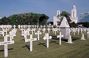
Menteng Pulo War Cemetery
Dutch war cemetery in Jakarta, Indonesia
Distance: Approx. 2408 meters
Latitude and longitude: -6.2223345,106.8394822
Menteng Pulo War Cemetery, also Dutch Field of Honor Menteng Pulo (Dutch: Nederlands Ereveld Menteng Pulo, Indonesian: Makam Kehormatan Belanda di Menteng Pulo), is a war cemetery at Jl. Menteng Pulo RT. 3 RW. 12, Menteng Dalam, Tebet, Jakarta in Indonesia. It is one of two Dutch war cemeteries in Jakarta, the other one is Ancol War Cemetery at Ancol.

Tebet Eco Park
Urban park in Tebet, Jakarta, Indonesia
Distance: Approx. 1596 meters
Latitude and longitude: -6.237329,106.852728
The Tebet Eco Park (Indonesian: Taman Eco Tebet) or Taman Kota Tebet is an urban park located in Tebet, Jakarta, Indonesia. The park has a land area of 7 hectares and it was previously known as Tebet Honda Park. It is a popular place for exercise, socialization, and recreation for neighboring community.

Cawang railway station
Railway station in Indonesia
Distance: Approx. 1846 meters
Latitude and longitude: -6.24189,106.858
Cawang Station (CW) is a class II railway station located at Jl. Tebet Timur Dalam 11, East Tebet, Tebet, South Jakarta, Indonesia. The station, which is located at the altitude of +26 meters, is included in Operational Area I Jakarta of Kereta Api Indonesia and only serves the KRL Commuterline route.

Matraman railway station
Railway station in Indonesia
Distance: Approx. 1469 meters
Latitude and longitude: -6.2124,106.8603
The Matraman Station (MTR) is the KRL Commuterline train station located on the border between Kebon Manggis, Matraman and Kampung Melayu, Jatinegara, East Jakarta, Indonesia. This station is adjacent to the Gunung Antang localization area and was built as the part of the Manggarai–Cikarang doubled-double track project.

Kampung Melayu (Transjakarta)
Bus station in Jakarta, Indonesia
Distance: Approx. 652 meters
Latitude and longitude: -6.22455,106.8668
Kampung Melayu is a Transjakarta bus rapid transit station located below the K.H. Abdullah Syafei overpass, at the middle of the interchange between Abdullah Syafei, Oto Iskandar di Nata, and Jatinegara Barat/Timur streets in Kampung Melayu, Jatinegara, East Jakarta, Indonesia. This is the terminus and transit point between corridors 5, 7, and 11. It stands on the former site of an open-air bus terminal for Kopaja, Metromini, and angkot/mikrolet routes.

Cikoko LRT Station
Distance: Approx. 2038 meters
Latitude and longitude: -6.243476,106.857102
Cikoko LRT Station is a light rail station located in Jalan Cikoko Barat, Cikoko, Pancoran, South Jakarta. The station, which is located at an altitude of +39.53 meters, serves the Cibubur and Bekasi lines of the Jabodebek LRT system.

Ciliwung LRT Station
Railway station in Indonesia
Distance: Approx. 2022 meters
Latitude and longitude: -6.243477,106.864131
Ciliwung LRT Station is a light rail station located in Jalan Letjen M.T. Haryono, Cawang, Kramat Jati, East Jakarta. The station, which is located at an altitude of +36.34 meters, serves the Cibubur and Bekasi lines of the Jabodebek LRT system.
Weather in this IP's area
scattered clouds
33 Celsius
39 Celsius
33 Celsius
33 Celsius
1006 hPa
57 %
1006 hPa
1004 hPa
6000 meters
2.57 m/s
10 degree
40 %
05:25:43
17:50:30