Country:
 The Bahamas
Region:
City:
Latitude and Longitude:
Time Zone:
Postal Code:
IP information under different IP Channel
ip-api
Country
Region
City
ASN
Time Zone
ISP
Blacklist
Proxy
Latitude
Longitude
Postal
Route
IPinfo
Country
Region
City
ASN
Time Zone
ISP
Blacklist
Proxy
Latitude
Longitude
Postal
Route
MaxMind
Country
Region
City
ASN
Time Zone
ISP
Blacklist
Proxy
Latitude
Longitude
Postal
Route
Luminati
Country
 US
USASN
Time Zone
America/Chicago
ISP
INVESCO
Latitude
Longitude
Postal
db-ip
Country
Region
City
ASN
Time Zone
ISP
Blacklist
Proxy
Latitude
Longitude
Postal
Route
ipdata
Country
Region
City
ASN
Time Zone
ISP
Blacklist
Proxy
Latitude
Longitude
Postal
Route
Popular places and events near this IP address
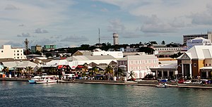
Nassau, The Bahamas
Capital and largest city of The Bahamas
Distance: Approx. 19 meters
Latitude and longitude: 25.04416667,-77.35027778
Nassau ( NASS-aw) is the capital and largest city of The Bahamas. It is located on the island of New Providence, which had a population of 246,329 in 2010, or just over 70% of the entire population of The Bahamas. As of April 2023, the preliminary results of the 2022 census of The Bahamas reported a population of 296,522 for New Providence, 74.26% of the country's population.
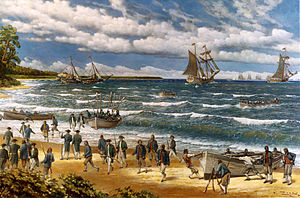
Raid of Nassau
1776 battle of the American Revolutionary War
Distance: Approx. 1831 meters
Latitude and longitude: 25.06,-77.345
The Raid of Nassau (March 3–4, 1776) was a naval operation and amphibious assault by American forces against the British port of Nassau, Bahamas, during the American Revolutionary War. The raid, designed to resolve the issue of gunpowder shortages, resulted in the seizure of two forts and large quantities of military supplies before the raiders drew back to New England, where they fought an unsuccessful engagement with a British frigate. During the American Revolutionary War, the Patriot forces suffered from a shortage of gunpowder.
University of the Bahamas
FIFA Club Beach Soccer World Cup Nassau 2017
Distance: Approx. 1959 meters
Latitude and longitude: 25.061709,-77.353251
The University of The Bahamas (UB) is the national public institution of higher education in the Commonwealth of The Bahamas with campuses throughout the archipelago. The main campus is located in the capital city of Nassau, on the island of New Providence. After more than thirty-five years of serving The Bahamas, first as a two-year institution, then as a four-year degree-granting College, the University of The Bahamas was chartered on November 10, 2016.

Thomas Robinson Stadium
Football stadium in Nassau, Bahamas
Distance: Approx. 1496 meters
Latitude and longitude: 25.05438056,-77.36021667
Thomas Robinson Stadium is a multi-purpose stadium in Nassau, Bahamas. The largest stadium in the country, it is currently used mostly for soccer matches. The stadium currently has a capacity of 15,000 people, but has the ability to be expanded to hold 23,000 people.

Fort Fincastle (The Bahamas)
Post revolutionary era fort in the Bahamas
Distance: Approx. 3473 meters
Latitude and longitude: 25.07361111,-77.33861111
Fort Fincastle is a fort located in the city of Nassau on the island of New Providence in The Bahamas. It was built to provide protection to Nassau. The fort, which is shaped like a paddle steamer, was built in 1793 by Lord Dunmore to protect Nassau from pirates.

Raid on Nassau
Distance: Approx. 1831 meters
Latitude and longitude: 25.06,-77.345
The Raid on Nassau, on the Bahamian island of New Providence, was a privately raised Franco-Spanish expedition against the English taking place in October 1703, during the War of the Spanish Succession; it was a Franco-Spanish victory, leading to Nassau's brief occupation, then its destruction. The joint Bourbon invasion was led by Blas Moreno Mondragón and Clause Le Chesnaye, with the attack focusing on Nassau, the capital of the English Bahamas, an important base of privateering for English corsairs in the Cuban and Saint Domingue's Caribbean seas. The town of Nassau was quickly taken and sacked, plundered and burnt down.
Raid on Charles Town
1684 Spanish Raid
Distance: Approx. 1831 meters
Latitude and longitude: 25.06,-77.345
The Raid on Charles Town, or Spanish raid on New Providence, was a Spanish naval expedition on 19 January 1684 (O.S.) led by Cuban corsair Juan de Alarcón against the English privateering stronghold of Charles Town (later renamed Nassau), capital of the Bahamas. The Bahamas harboured pirates and privateers who preyed on Spanish ships. Governor Clarke, described as "one of Cromwell's officers" justified privateering as necessary for the colony's defence, but in one letter of marque he authorized offensive attacks on Spanish holdings far from the Bahamas.
Roscow A. L. Davies Soccer Field
Distance: Approx. 820 meters
Latitude and longitude: 25.049656,-77.355975
The Roscow AL Davies Soccer Field is a sports venue located in Nassau, Bahamas. It is currently used mostly for soccer matches and is a part of the larger Baillou Hills Sporting Complex.
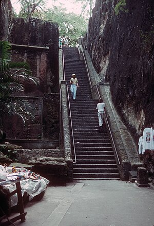
Queen's Staircase (Nassau)
Landmark in Nassau, Bahamas
Distance: Approx. 3458 meters
Latitude and longitude: 25.07313889,-77.33766667
The Queen's Staircase is a walkway of 66 steps in Nassau, the capital city of The Bahamas. It was carved out of solid limestone rock by 600 slaves between 1793 and 1794 to create an escape route from the fort above and is a major landmark of Nassau. The stairs are located at Fort Fincastle Historic Complex near Bennet's Hill in Downtown Nassau next to Princess Margaret Hospital and Grosvenor Campus of the University of the Bahamas.
Government High School, Nassau
High school in Nassau, Bahamas
Distance: Approx. 1242 meters
Latitude and longitude: 25.0483,-77.3619
Government High School is a state secondary school in Nassau, Bahamas. At one time, it was a selective grammar school and one of the country's leading institutions.
Jamaa' Ahlus Sunnah Bahamas Mosque
Mosque in Nassau, New Providence, The Bahamas
Distance: Approx. 3124 meters
Latitude and longitude: 25.02366667,-77.37138889
The Jamaa' Ahlus Sunnah Bahamas Mosque is a mosque in Nassau, New Providence, The Bahamas.
Andre Rodgers National Baseball Stadium
Baseball stadium in Nassau, Bahamas
Distance: Approx. 1496 meters
Latitude and longitude: 25.05438056,-77.36021667
Andre Rodgers National Baseball Stadium is a baseball stadium in Nassau, Bahamas. Opening in 2022, it is the largest baseball-specific stadium in the country, and is built to international and Major League Baseball standards. Andre Rodgers Stadium hosted the 2022 Caribbean Baseball Cup, a qualifying tournament for the 2023 Central American and Caribbean Games.
Weather in this IP's area
scattered clouds
29 Celsius
34 Celsius
29 Celsius
29 Celsius
1014 hPa
76 %
1014 hPa
1013 hPa
10000 meters
6.73 m/s
7.28 m/s
133 degree
50 %
06:53:11
19:21:00