Country:
 Indonesia
Region:
City:
Latitude and Longitude:
Time Zone:
Postal Code:
IP information under different IP Channel
ip-api
Country
Region
City
ASN
Time Zone
ISP
Blacklist
Proxy
Latitude
Longitude
Postal
Route
IPinfo
Country
Region
City
ASN
Time Zone
ISP
Blacklist
Proxy
Latitude
Longitude
Postal
Route
MaxMind
Country
Region
City
ASN
Time Zone
ISP
Blacklist
Proxy
Latitude
Longitude
Postal
Route
Luminati
Country
IDASN
Time Zone
Asia/Jakarta
ISP
PT Parsaoran Global Datatrans
Latitude
Longitude
Postal
db-ip
Country
Region
City
ASN
Time Zone
ISP
Blacklist
Proxy
Latitude
Longitude
Postal
Route
ipdata
Country
Region
City
ASN
Time Zone
ISP
Blacklist
Proxy
Latitude
Longitude
Postal
Route
Popular places and events near this IP address

Pancoran, South Jakarta
District of South Jakarta
Distance: Approx. 582 meters
Latitude and longitude: -6.2579045,106.82304181
Pancoran is a district (kecamatan) of South Jakarta, one of the five administrative cities that form Jakarta, Indonesia. Pancoran District was originally part of Mampang Prapatan District until it was split off to form its district in 1990. The boundaries of Pancoran District are the Ciliwung River to the east, the Mampang River to the west, and Kapten Tendean Road - Jend.
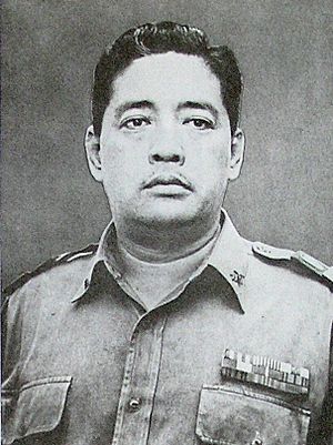
Soeprapto (general)
Indonesian general (1920–1965)
Distance: Approx. 2008 meters
Latitude and longitude: -6.25722222,106.84611111
Lieutenant General R. Soeprapto (20 June 1920 – 1 October 1965) was the Second Deputy Commander of the Indonesian Army, and was kidnapped from his home in Jakarta by members of the 30 September Movement in the early hours of 1 October. He was later killed at Lubang Buaya.

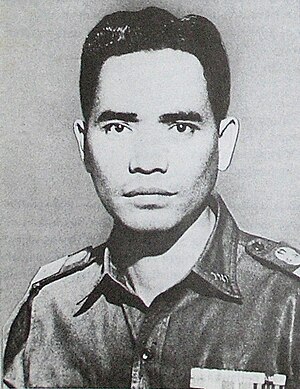
Siswondo Parman
Indonesian general (1918–1965)
Distance: Approx. 2008 meters
Latitude and longitude: -6.25722222,106.84611111
Lieutenant General Siswondo Parman (4 August 1918 – 1 October 1965) or more popularly known such as in streets name as S. Parman, was a soldier in the Indonesian Army, and was kidnapped from his home in Jakarta by members of the 30 September Movement in the early hours of October 1. He was later killed at Lubang Buaya.

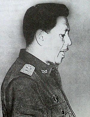
Mas Tirtodarmo Haryono
Indonesian general (1924–1965)
Distance: Approx. 2008 meters
Latitude and longitude: -6.25722222,106.84611111
Lieutenant General Mas Tirtodarmo Haryono (20 January 1924 – 1 October 1965) was a general officer in the Indonesian Army who was killed during an attempt to kidnap him from his home by members of the 30 September Movement in the early hours of 1 October 1965.
D. I. Pandjaitan
Indonesian general (1925–1965)
Distance: Approx. 2008 meters
Latitude and longitude: -6.25722222,106.84611111
Major General Donald Izacus Pandjaitan (9 June 1925 – 1 October 1965) was an Indonesian General who was killed during a kidnap attempt by the members of the 30 September Movement. Among the 6 Army Generals who perished during the coup attempt, he was the sole Christian.
Sutoyo Siswomiharjo
Indonesian general (1922–1965)
Distance: Approx. 2008 meters
Latitude and longitude: -6.25722222,106.84611111
Major General Sutoyo Siswomiharjo (28 August 1922 – 1 October 1965) was an Indonesian general who was kidnapped and later murdered during the attempted coup by the 30 September Movement.

Halim Perdanakusuma
Indonesian airman and National Hero of Indonesia
Distance: Approx. 2038 meters
Latitude and longitude: -6.25722222,106.84638889
Air Vice-Marshal Abdul Halim Perdanakusuma (18 November 1922 – 14 December 1947), better known as Halim Perdanakusuma, was an Indonesian airman and National Hero of Indonesia.

Kalibata Heroes' Cemetery
Military cemetery in Jakarta
Distance: Approx. 2008 meters
Latitude and longitude: -6.25722222,106.84611111
The National Main Heroes' Cemetery in Kalibata (Indonesian: Taman Makam Pahlawan Nasional Utama Kalibata), colloquially known as Kalibata Heroes' Cemetery (Indonesian: Taman Makam Pahlawan Kalibata or TMP Kalibata), is a military cemetery in Kalibata, South Jakarta, Indonesia. It was built in 1953 and opened on 10 November 1954. Bacharuddin Jusuf Habibie was the first Indonesian President to be buried in the cemetery following his death on 11 September 2019.

New Zealand School Jakarta
School in Indonesia
Distance: Approx. 1513 meters
Latitude and longitude: -6.2645,106.8172
The New Zealand School Jakarta (NZSJ), formerly New Zealand Independent School, is an international school located in Kemang, South Jakarta (Jakarta Selatan), Jakarta, Indonesia. It was established in 2002. The school changed its name from New Zealand International School (NZIS) following the ruling by the Government of Indonesia in 2014 that all schools had to remove the word international from their name.
Kemang, Jakarta
Place in Jakarta, Indonesia
Distance: Approx. 950 meters
Latitude and longitude: -6.2608,106.8208
Kemang is a neighborhood in southern part of Jakarta, Indonesia. The area is located mostly in Bangka subdistrict of Mampang Prapatan and partly within Pejaten subdistrict of Pasar Minggu. The main area of Kemang is marked by the roads of Kemang Raya, Prapanca, and Bangka Streets.

Kemang Village
Shopping mall in Jakarta, Indonesia
Distance: Approx. 1864 meters
Latitude and longitude: -6.259418,106.811473
Kemang Village is an integrated development of vertical residences with a shopping mall named Lippo Mall Kemang, hotel, hospital, school, country club, and spa, located at Mampang Prapatan, South Jakarta, Indonesia. The complex has a land area of about 15.5 hectares (38 acres), which is developed by Lippo Group.
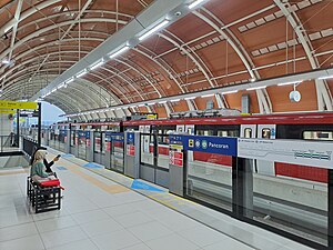
Pancoran Bank BJB LRT Station
LRT station in Indonesia
Distance: Approx. 1945 meters
Latitude and longitude: -6.24212721,106.8384693
Pancoran LRT Station (or Pancoran Bank BJB LRT Station, with Bank BJB granted for naming rights) is a light rail station located in Jalan Gatot Subroto, Pancoran, Pancoran, South Jakarta. The station, which is located at an altitude of +38.510 meters, serves the Cibubur and Bekasi lines of the Jabodebek LRT system.
Weather in this IP's area
broken clouds
30 Celsius
32 Celsius
29 Celsius
32 Celsius
1014 hPa
61 %
1014 hPa
1011 hPa
6000 meters
3.09 m/s
240 degree
77 %
05:29:18
17:45:19