Country:
 Australia
Region:
City:
Latitude and Longitude:
Time Zone:
Postal Code:
IP information under different IP Channel
ip-api
Country
Region
City
ASN
Time Zone
ISP
Blacklist
Proxy
Latitude
Longitude
Postal
Route
IPinfo
Country
Region
City
ASN
Time Zone
ISP
Blacklist
Proxy
Latitude
Longitude
Postal
Route
MaxMind
Country
Region
City
ASN
Time Zone
ISP
Blacklist
Proxy
Latitude
Longitude
Postal
Route
Luminati
Country
AUASN
Time Zone
Australia/Sydney
ISP
TPG Telecom Limited
Latitude
Longitude
Postal
db-ip
Country
Region
City
ASN
Time Zone
ISP
Blacklist
Proxy
Latitude
Longitude
Postal
Route
ipdata
Country
Region
City
ASN
Time Zone
ISP
Blacklist
Proxy
Latitude
Longitude
Postal
Route
Popular places and events near this IP address

St Kilda Junction
Road intersection in St Kilda, Australia
Distance: Approx. 728 meters
Latitude and longitude: -37.855,144.982
St Kilda Junction is a major intersection in Melbourne, Australia. It is in the suburb of St Kilda, bordering Windsor and St Kilda East, and is the meeting point of the major roads Punt Road, St Kilda Road, Dandenong Road/Queens Way/Princes Highway and Fitzroy Street.

Albert Park and Lake
Lake in Melbourne, Australia
Distance: Approx. 710 meters
Latitude and longitude: -37.848,144.971
Albert Park is a large public park in the City of Port Phillip, an inner suburban LGA of Melbourne, Victoria, Australia. Located 3 km (1.9 mi) south of the Melbourne central business district, the park encompasses 2.25 km2 (225 ha; 560 acres) of parkland around the 1.8 km (1.1 mi) long Albert Park Lake, a 0.49 km2 (49 ha; 120 acres) Y-shaped artificial lake used both for water sports and public recreation. The park is an important site for the sporting culture of Melbourne and Victoria, hosting multiple sports venues such as the Lakeside Stadium, the Melbourne Sports and Aquatic Centre and other indoor sports facilities, the Albert Park Yacht Club and Albert Sailing Club, the Albert Park Golf Course, a 4.7-kilometre (2.9 mi) walking track around the lake, numerous ovals, and the Albert Park Circuit motor racing track.
Wesley College, Melbourne
Independent school in Victoria, Australia
Distance: Approx. 261 meters
Latitude and longitude: -37.84916667,144.98194444
Wesley College is a co-educational, open-entry private school in Melbourne, Australia. Established in 1866, the college is the only school in Victoria to offer the International Baccalaureate (IB) from early childhood to Year 12. The college consists of three main metropolitan campuses in Melbourne, St Kilda Road, Glen Waverley and Elsternwick, residential/boarding facilities (Glen Waverley), three outdoor education sites (Mallana, Chum Creek, & Lochend), a year 9 residential learning campus in Clunes and the Yiramalay/Wesley Studio School (Yiramalay) in the Kimberley Region.

Victorian College for the Deaf
Department of education (victoria) school in Melbourne, Victoria, Australia
Distance: Approx. 324 meters
Latitude and longitude: -37.8498,144.9825
The Victorian College for the Deaf (VCD), located on St Kilda Road in Melbourne, Australia, is Victoria's oldest deaf school, opening in 1860. The Victorian College for the Deaf is Australia's only Prep to Year 12 Specialist in Deaf Education. Education is provided using a bilingual philosophy of teaching through Auslan, the language of the Australian deaf community, and English as the second language.

The Alfred Hospital
Hospital in Victoria, Australia
Distance: Approx. 450 meters
Latitude and longitude: -37.8461,144.9827
The Alfred Hospital, (also known as The Alfred or Alfred Hospital) is a leading tertiary hospital in Melbourne, Victoria. It is the second oldest hospital in Victoria after Melbourne Hospital which is still operating on its original site. The hospital is one of two major adult trauma centers in Victoria and houses the largest intensive care unit in Australia.
Baker Heart and Diabetes Institute
Distance: Approx. 512 meters
Latitude and longitude: -37.84583333,144.98333333
The Baker Heart and Diabetes Institute, commonly known as the Baker Institute, is an Australian independent medical research institute headquartered in Melbourne, Victoria. Established in 1926, the institute is one of Australia's oldest medical research organisations with a historical focus on cardiovascular disease. In 2008, it became the country's first medical research institute to target diabetes, heart disease, obesity and their complications at the basic, clinical and population health levels.
Mansion nightclub
Distance: Approx. 629 meters
Latitude and longitude: -37.85441944,144.98051944
The Mansion is located in Melbourne, Australia, at 83 Queens Road. The multi-level historic building was an electronic music venue. The Mansion was once voted No.7 in the world’s top 10 clubs.

Albert Cricket Ground
Distance: Approx. 424 meters
Latitude and longitude: -37.84527778,144.9775
Albert Cricket Ground, also known as the Albert Reserve and previously as the Warehouseman's Cricket Ground, is a cricket ground in St Kilda, Victoria. It is operated by the Melbourne Cricket Club (MCC), and used as its primary home ground in the Victorian Premier Cricket competition.
South Yarra Province
Former electoral province of the Victorian Legislative Council, Australia
Distance: Approx. 400 meters
Latitude and longitude: -37.85,144.98333333
South Yarra Province was an electorate of the Victorian Legislative Council from November 1882 until May 1904. South Yarra Province was created in the redistribution of provinces in 1882 when the Central and Eastern Provinces were abolished. The new South Yarra, North Yarra, North Central, South Eastern and Melbourne Provinces were then created.
Melbourne South Province
Former electoral province of the Victorian Legislative Council, Australia
Distance: Approx. 400 meters
Latitude and longitude: -37.85,144.98333333
Melbourne South Province was an electorate of the Victorian Legislative Council. It was created in June 1904 when Melbourne Province was reduced in size (four members down to two) and North Yarra Province and South Yarra Province were abolished. The new Melbourne South, Melbourne North, Melbourne East and Melbourne West Provinces were then created.
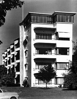
Newburn Flats
Building in Melbourne, Australia
Distance: Approx. 727 meters
Latitude and longitude: -37.842861,144.975866
Newburn Flats is an apartment building located at 30 Queens Road, Melbourne. It is considered one of the first examples of European Modernist ideals applied to multi-unit residences in Australia. It was designed by the firm Romberg & Shaw (Frederick Romberg and Mary Turner Shaw) in 1939 and completed in 1941.

Sheridan Close Apartment Block
Distance: Approx. 715 meters
Latitude and longitude: -37.8425,144.9783
Sheridan Close is a low-rise apartment complex situated on 485–489 St Kilda Road, Melbourne, Victoria, Australia. It has direct access onto Fawkner Park at the rear of the building. It was designed by the architect Sir Bernard Evans, who later became Lord Mayor of Melbourne (between 1959 and 1961), and was built by Prentice Builders.
Weather in this IP's area
clear sky
12 Celsius
10 Celsius
9 Celsius
13 Celsius
1019 hPa
65 %
1019 hPa
1017 hPa
10000 meters
3.23 m/s
8.25 m/s
7 degree
06:41:53
19:31:59