Country:
Region:
City:
Latitude and Longitude:
Time Zone:
Postal Code:
IP information under different IP Channel
ip-api
Country
Region
City
ASN
Time Zone
ISP
Blacklist
Proxy
Latitude
Longitude
Postal
Route
Luminati
Country
Region
10
City
kualaselangor
ASN
Time Zone
Asia/Kuala_Lumpur
ISP
IP ServerOne Solutions Sdn Bhd
Latitude
Longitude
Postal
IPinfo
Country
Region
City
ASN
Time Zone
ISP
Blacklist
Proxy
Latitude
Longitude
Postal
Route
db-ip
Country
Region
City
ASN
Time Zone
ISP
Blacklist
Proxy
Latitude
Longitude
Postal
Route
ipdata
Country
Region
City
ASN
Time Zone
ISP
Blacklist
Proxy
Latitude
Longitude
Postal
Route
Popular places and events near this IP address

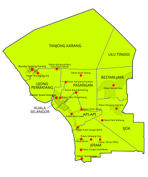
Kuala Selangor
Town in Selangor, Malaysia
Distance: Approx. 2195 meters
Latitude and longitude: 3.3332,101.2542
Kuala Selangor is a town in northwestern Selangor, Malaysia. It is the largest town and administrative centre of the coterminous Kuala Selangor District.
Sultan Ibrahim Mosque
Mosque in Kuala Selangor, Selangor, Malaysia
Distance: Approx. 2831 meters
Latitude and longitude: 3.3285,101.25775
Sultan Ibrahim Mosque is the district mosque of Kuala Selangor, Selangor, Malaysia.

Bukit Rotan
Distance: Approx. 9631 meters
Latitude and longitude: 3.3,101.31666667
Bukit Rotan is a small town in Kuala Selangor District, Selangor, Malaysia. The Kampung Kuantan's fireflies, a major tourist attraction is located here. It was a big area for plantation.

Selangor River
River in Selangor, Malaysia
Distance: Approx. 1540 meters
Latitude and longitude: 3.35,101.23333333
The Selangor River (Malay: Sungai Selangor) is a major river in Selangor, Malaysia. It runs from Kuala Kubu Bharu in the east and empties into the Straits of Malacca at Kuala Selangor in the west.

Assam Jawa
Distance: Approx. 6634 meters
Latitude and longitude: 3.2998207,101.2766609
Assam Jawa is a small town in Kuala Selangor District, Selangor, Malaysia. This town has a T-junction which connects Kuala Selangor to Kuala Lumpur through Jalan Kuala Selangor Federal Route 54.

Sultan Salahuddin Abdul Aziz Shah Bridge
Bridge in Federal Route Jalan Kuala Selangor-Sabak Bernam
Distance: Approx. 1361 meters
Latitude and longitude: 3.34072222,101.25269444
The Sultan Salahuddin Abdul Aziz Shah Bridge (Malay: Jambatan Sultan Salahuddin Abdul Aziz Shah) is a main bridge in Kuala Selangor District, Selangor, Malaysia crossing Selangor River.

SMS Kuala Selangor
Fully residential school in Selangor, Malaysia
Distance: Approx. 4441 meters
Latitude and longitude: 3.3225,101.27443333
Sekolah Menengah Sains Kuala Selangor (English: Kuala Selangor Science Secondary School; abbreviated KUSESS) is a Fully Residential School, also known as Sekolah Berasrama Penuh (SBP) in Malaysia. KUSESS was then built under the Sixth Malaysia Plan. It is located near Bandar Melawati, Kuala Selangor which is about 70 kilometres from the nation's capital, Kuala Lumpur.
SM Sultan Abdul Halim
School in Jenan, Kedah, Malaysia
Distance: Approx. 4441 meters
Latitude and longitude: 3.3225,101.27443333
Sekolah Menengah Sultan Abdul Halim (English: Sultan Abdul Halim Secondary School; abbreviated SMSAH) is a premier boarding school, located in Jitra, Kubang Pasu, Kedah.Established in 1963 under Razak Report, it is the first boarding school in Kedah. The school is nicknamed as Jenan. In 2010, the school was awarded with the Sekolah Berprestasi Tinggi or High Performance School title, a title awarded to the 20 schools in Malaysia that have met stringent criteria including academic achievement, strength of alumni, international recognition, network and linkages.
Bukit Malawati
Historic hillfort in Malaysia
Distance: Approx. 1080 meters
Latitude and longitude: 3.34194444,101.24611111
Bukit Malawati (Malawati Hill in English) is a fort located in Kuala Selangor, Selangor, Malaysia. Managed by the Kuala Selangor Municipal Council, Bukit Malawati is a popular local tourist attraction. It has strategic importance because of its position at the mouth of the Selangor River which drains into the Strait of Malacca, with vantages on both the Strait and Sumatra, Indonesia.
Weather in this IP's area
light rain
31 Celsius
38 Celsius
31 Celsius
31 Celsius
1009 hPa
78 %
1009 hPa
1008 hPa
10000 meters
2.46 m/s
2.04 m/s
280 degree
96 %
07:01:47
18:59:21