Country:
Region:
City:
Latitude and Longitude:
Time Zone:
Postal Code:
IP information under different IP Channel
ip-api
Country
Region
City
ASN
Time Zone
ISP
Blacklist
Proxy
Latitude
Longitude
Postal
Route
Luminati
Country
Region
vic
City
melbourne
ASN
Time Zone
Australia/Melbourne
ISP
Over The Wire Pty Ltd
Latitude
Longitude
Postal
IPinfo
Country
Region
City
ASN
Time Zone
ISP
Blacklist
Proxy
Latitude
Longitude
Postal
Route
db-ip
Country
Region
City
ASN
Time Zone
ISP
Blacklist
Proxy
Latitude
Longitude
Postal
Route
ipdata
Country
Region
City
ASN
Time Zone
ISP
Blacklist
Proxy
Latitude
Longitude
Postal
Route
Popular places and events near this IP address

Dandenong, Victoria
Suburb of Melbourne, Victoria, Australia
Distance: Approx. 1542 meters
Latitude and longitude: -37.981,145.215
Dandenong ( DAN-dih-nong) is a southeastern suburb of Melbourne, Victoria, Australia, about 29 km (18 mi) from the Melbourne CBD. It is the council seat of the City of Greater Dandenong local government area, with a recorded population of 30,127 at the 2021 census. Situated mainly on the northwest bank of the lower Dandenong Creek, it is 21.6 km (13.4 mi) from the eponymous Dandenong Ranges to its northeast and completely unrelated in both location and nature of the settlement. A regional transport hub and manufacturing centre of Victoria, Dandenong is located at the junctional region of the Dandenong Valley Highway, Princes Highway, Monash Freeway and Dingley Freeway, and is the gateway town of the Gippsland railway line into West Gippsland.
Keysborough, Victoria
Suburb of Melbourne, Victoria, Australia
Distance: Approx. 2337 meters
Latitude and longitude: -37.989,145.172
Keysborough is a suburb in Melbourne, Victoria, Australia, 27 km (17 mi) southeast of the Melbourne central business district, located within the City of Greater Dandenong local government area. Keysborough recorded a population of 30,018 at the 2021 census. Keysborough is one of the largest suburbs in Melbourne by land area.

Yarraman railway station
Railway station in Melbourne, Australia
Distance: Approx. 953 meters
Latitude and longitude: -37.978,145.1915
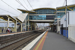
Yarraman railway station is a commuter railway station located in the suburbs of Noble Park and Dandenong, in Melbourne, Victoria, Australia. The station was named after the nearby Yarraman Creek, a first-order tributary of the lower Dandenong Creek/Patterson River system. The station is currently served by the Pakenham and Cranbourne lines, part of the Melbourne railway network.

Dandenong railway station
Railway station in Melbourne, Australia
Distance: Approx. 1178 meters
Latitude and longitude: -37.99,145.2098
Dandenong railway station is a commuter, regional railway station and the junction point of the Pakenham and Cranbourne lines, which are both part of the Melbourne railway network. It serves the south-eastern suburb of Dandenong, in Melbourne, Victoria, Australia. Dandenong station is a ground level premium station, featuring three platforms, an island platform with two faces and one side platform.

Chisholm Institute
Vocational education college in Melbourne, Australia
Distance: Approx. 2179 meters
Latitude and longitude: -37.97518889,145.21973889
Chisholm Institute is a government-owned Technical and Further Education (TAFE) Institute located in south-east Melbourne Australia. It provides adult education in several areas including the arts, hospitality, information technology, trades and business. Chisholm offers over 250 certificate, diploma, advanced diploma, bachelor and graduate certificate courses.

Electoral district of Dandenong
State electoral district of Victoria, Australia
Distance: Approx. 1637 meters
Latitude and longitude: -37.98333333,145.21666667
The electoral district of Dandenong is an electoral district of the Victorian Legislative Assembly. It was first proclaimed in 1904 when the district of Dandenong and Berwick was abolished. The district is located within the outskirts of Melbourne's south-east, containing both residential and industrial areas, as well as the Armada Dandenong Plaza and Churchill National Park.

Noble Park Secondary College
Government, coeducation school in Noble Park, Victoria, Australia
Distance: Approx. 1866 meters
Latitude and longitude: -37.97194444,145.18444444
Noble Park Secondary College is a secondary 7–12 co-educational school in Noble Park, Melbourne. According to the school, they have enrolled over 40 different nationalities into the school, with 44% of the students being born outside Australia. Its sister school is Shinminato Senior High School.
Dandenong High School
State school in Dandenong, Victoria, Australia
Distance: Approx. 1156 meters
Latitude and longitude: -37.97916667,145.20916667
Dandenong High School is one of the largest co-educational government secondary schools in Melbourne, Victoria, Australia, catering for students from Years 7 to 12. It is the oldest school, public or private, in Melbourne's outer east, and now has 1400 students alone on its Dandenong site on the north side of the Princes Highway. The historic façade of the Administration Building will remain, as it is heritage-listed and is a landmark of Dandenong.

City of Dandenong
Local government area in Victoria, Australia
Distance: Approx. 1314 meters
Latitude and longitude: -37.986,145.213
The City of Dandenong was a local government area about 35 kilometres (22 mi) southeast of Melbourne, the state capital of Victoria, Australia. The city covered an area of 36.26 square kilometres (14.00 sq mi), and existed from 1857 until 1994.

Dandenong Square
Shopping mall in Victoria, Australia
Distance: Approx. 1669 meters
Latitude and longitude: -37.98673,145.21696
Dandenong Square, originally known as Dandenong Plaza, is a major-regional shopping centre located in the suburb of Dandenong, approximately 30 kilometres south-east of the Melbourne CBD. The centre has two large food courts (one on level 1 and another outside Reading Cinemas on level 2). Level 3 has a large Fresh Food Hall outside the Coles supermarket. Dandenong Square is within close proximity to the Dandenong Market and also Dandenong Hub.
Bend Road archaeological site
Distance: Approx. 2254 meters
Latitude and longitude: -38.00411,145.190377
The Bend Road archaeological site is an open site in Melbourne, Australia. It was discovered during survey and archaeological testing for the proposed Scoresby Freeway, which became the EastLink Freeway. The site is located in two separate areas on either side of Bend Road, Dandenong South (Bend Road 1 to the north, Bend Road 2 to the south) where the freeway now intersects the former road, and originally covered about 12 hectares.

Albanian Mosque, Dandenong
Distance: Approx. 1385 meters
Latitude and longitude: -37.994182,145.208464
The Albanian Mosque (Albanian: Xhamija Shqiptare Dandenong Këshavë), also known as the Albanian Islamic Centre Mosque and Albanian Sakie Islamic Centre, is a mosque located in Dandenong, a south eastern suburb of Melbourne, Victoria, Australia. It is one of the earliest mosques in the country. The mosque is a large building, built next to Dandenong Creek and residential neighbourhood, with a minaret, and community facilities.
Weather in this IP's area
clear sky
19 Celsius
18 Celsius
17 Celsius
20 Celsius
1019 hPa
52 %
1019 hPa
1015 hPa
10000 meters
3.58 m/s
6.71 m/s
224 degree
4 %
05:59:31
20:07:57
