Country:
 Pakistan
Region:
City:
Latitude and Longitude:
Time Zone:
Postal Code:
IP information under different IP Channel
ip-api
Country
Region
City
ASN
Time Zone
ISP
Blacklist
Proxy
Latitude
Longitude
Postal
Route
IPinfo
Country
Region
City
ASN
Time Zone
ISP
Blacklist
Proxy
Latitude
Longitude
Postal
Route
MaxMind
Country
Region
City
ASN
Time Zone
ISP
Blacklist
Proxy
Latitude
Longitude
Postal
Route
Luminati
Country
PKRegion
sd
City
karachi
ASN
Time Zone
Asia/Karachi
ISP
Fiber Beam Pvt Limited
Latitude
Longitude
Postal
db-ip
Country
Region
City
ASN
Time Zone
ISP
Blacklist
Proxy
Latitude
Longitude
Postal
Route
ipdata
Country
Region
City
ASN
Time Zone
ISP
Blacklist
Proxy
Latitude
Longitude
Postal
Route
Popular places and events near this IP address

Keamari (locality)
Locality in Karachi, Sindh, Pakistan
Distance: Approx. 2887 meters
Latitude and longitude: 24.81666667,66.98333333
Keamari (Sindhi: ڪياماڙي, Urdu: کیماڑی) is a neighbourhood in Karachi, Sindh, Pakistan. Keamari was originally an independent settlement that was built on a sandy ridge on the eastern side of Karachi Harbour.
Oyster Rocks, Karachi
Distance: Approx. 2804 meters
Latitude and longitude: 24.80055556,66.99833333
The Clifton Oyster Rocks (Urdu: کستورا مچهلی) are a series of islets located off the coast of the Clifton neighbourhood of Karachi, Sindh, Pakistan. The islands were under the control of the Pakistani Navy until 2006, when the Karachi city government decided to include the island as part of its plans to renovate the city. As part of these plans, the Port Fountain was constructed at the base of the northern island.

Pakistan Naval Academy
Academy of the Pakistan Navy
Distance: Approx. 822 meters
Latitude and longitude: 24.80027778,66.97222222
The Pakistan Naval Academy (PNA), PNS Rahbar, Manora is a federal military academy located in Manora, Karachi, Sindh, Pakistan. Established in Manora, Karachi, under Vice-Admiral Syed Mohammad Ahsan in 1970, it is the one of the technologically advanced military training academy in Pakistan that offers professional academic degrees. Its functions and roles are similar to United States Naval Academy in Annapolis, Maryland, United States.
Manora, Karachi
Municipality in Sindh, Pakistan
Distance: Approx. 583 meters
Latitude and longitude: 24.79405556,66.97752778
Manora (Sindhi: منهوڙو, Urdu: منوڑہ) is a small peninsula that forms a protective barrier between Karachi Harbour to the north and the Arabian Sea to the south. Manora, having a total population of 4,273 local residents (as per 2017 census), was formerly an island, but due to silting is now connected to the mainland by a 12 kilometer long natural sandbridge known as Sandspit. The entrance to Karachi was once guarded against pirate raids by the Manora Fort built in the 1790s, which was later upgraded by the British, and then the Pakistan Navy.
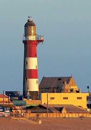
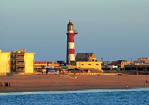
Manora Point Lighthouse
Lighthouse
Distance: Approx. 577 meters
Latitude and longitude: 24.79388889,66.9775
The Manora Point Lighthouse is an active lighthouse located in Manora, Karachi, on the Arabian Sea in Pakistan, where it is fourth tallest lighthouse in the country at a height of 38 m (125 ft). The lighthouse was first established on the point in 1851, being second oldest light station in the former British Indian Empire. Extensively rebuilt in 1889, it still remains operational today as a navigational aid for ships entering the nearby Port of Karachi.
PNS Qasim
Pakistan Navy's base for marine logistics.
Distance: Approx. 854 meters
Latitude and longitude: 24.79,66.97972222
The Pakistan Navy Station Qasim (reporting name: PNS Qasim), is a naval base located in Manora Island, off the Karachi coast in Sindh, Pakistan. While serving as a military logistics base for the Pakistan Marines, PNS Qasim also provides initial military training to Pakistan Marines, a maritime land warfare branch of the Pakistan Navy.

Shri Varun Dev Mandir
Hindu temple on Manora Island, in Karachi, Pakistan
Distance: Approx. 533 meters
Latitude and longitude: 24.79758333,66.97080556
Shri Varun Dev Mandir (Sindhi: شْرِيْ وَرُڻَ ديوَ مَنْدِرَ ,श्री वरुण देव मंदिर, Urdu: شْرِیْ وَرُنَ دیوَ مَنْدِرَ) is a Hindu temple located in Manora Island in Karachi, Sindh, Pakistan. The temple is devoted to Lord Jhulelal (Varuna), the deity that represents water in Hinduism. He is the chief governing deity of all the Seas-Oceans and the Sindh river.

Karachi Harbour
Bay and estuary in Pakistan
Distance: Approx. 2514 meters
Latitude and longitude: 24.81533333,66.969
Karachi Harbour is a narrow bay and river estuary located west of the Indus River Delta in Karachi, Pakistan. The harbour lies between the Lyari River delta and Chinna Creek to the north, and the Arabian Sea to the south. Since 1886, sections of the harbour have been improved to form the Port of Karachi - Pakistan's busiest seaport.
Kiamari Railway Station
Train station in Pakistan
Distance: Approx. 2887 meters
Latitude and longitude: 24.81666667,66.98333333
Kiamari Railway Station (Urdu: کیماڑی ریلوے اسٹیشن, Sindhi: ڪياماڙي ريلوي اسٽيشن) is located in Kiamari Town, Karachi, Sindh, Pakistan.

PNS Iqbal
Pakistan Navy's base for special operations forces.
Distance: Approx. 854 meters
Latitude and longitude: 24.79,66.97972222
The Pakistan Navy Station Iqbal (reporting name: PNS Iqbal) is a naval base located off the Karachi coast, Sindh, Pakistan.: 280 The PNS Iqbal serves as the command post of the Pakistan Navy Special Service Group that were commissioned in 1966.: 280 Besides serving as the headquarter of the Special Service Group (Navy), the PNS Iqbal is a submarine base for the Cosmos-class submarine, and served as a submarine base since its establishment in 1968.: 286 : 78 The School of Special Operations Forces is also based in the PNS Iqbal where navy personnels are trained, qualified, and certified for special operations including qualified in advanced underwater diving courses.
PNS Himalaya
Pakistan Navy's training formation on recruit training.
Distance: Approx. 854 meters
Latitude and longitude: 24.79,66.97972222
The Pakistan Navy Station Himalaya (reporting name: PNS Himalaya), is a naval base located in Manora Island, off the coast of Karachi coast, Sindh, Pakistan. The PNS Himalaya is primarily responsible for conducting the initial orientation of incoming recruits, also known as boot camp and distinguished itself as "Home of Armed Forces Diving School". The naval base is namesake after the famous Himalaya Mountain Range in Northern Pakistan.
Tasman Spirit oil spill
2003 oil spill in Karachi
Distance: Approx. 2629 meters
Latitude and longitude: 24.782683,66.995352
The Tasman Spirit oil spill occurred in the Arabian Sea just outside the Port of Karachi, Karachi, Pakistan on July 27, 2003, when Tasman Spirit, an oil tanker owned by Maltese company Assimina Maritime, bound for the Port of Karachi, Karachi from Kharg Island, Iran, ran aground while navigating to the Port of Karachi, at the Clifton Beach, at 12:57 p.m. local time and spilled approximately 30,000 metric tonnes of light crude oil over the next few days. It is considered to be one of the worst human-caused environmental disasters in Pakistan.
Weather in this IP's area
clear sky
27 Celsius
29 Celsius
27 Celsius
27 Celsius
1010 hPa
67 %
1010 hPa
1010 hPa
10000 meters
3.49 m/s
4.06 m/s
326 degree
2 %
06:31:58
18:01:48