Country:
Region:
City:
Latitude and Longitude:
Time Zone:
Postal Code:
IP information under different IP Channel
ip-api
Country
Region
City
ASN
Time Zone
ISP
Blacklist
Proxy
Latitude
Longitude
Postal
Route
Luminati
Country
ASN
Time Zone
Asia/Jakarta
ISP
PT. Jaringan Prima Data Nusantara
Latitude
Longitude
Postal
IPinfo
Country
Region
City
ASN
Time Zone
ISP
Blacklist
Proxy
Latitude
Longitude
Postal
Route
db-ip
Country
Region
City
ASN
Time Zone
ISP
Blacklist
Proxy
Latitude
Longitude
Postal
Route
ipdata
Country
Region
City
ASN
Time Zone
ISP
Blacklist
Proxy
Latitude
Longitude
Postal
Route
Popular places and events near this IP address

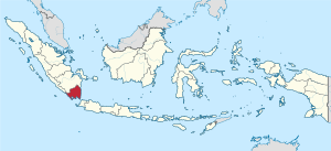
Lampung
Province of Indonesia
Distance: Approx. 7179 meters
Latitude and longitude: -5.45,105.26666667
Lampung, officially the Province of Lampung (Indonesian: Provinsi Lampung), is a province of Indonesia. It is located on the southern tip of the island of Sumatra. It has a short border with the province of Bengkulu to the northwest, and a longer border with the province of South Sumatra to the north, as well as a maritime border with the provinces of Banten and Jakarta to the east.
Bandar Lampung
City and capital of Lampung, Indonesia
Distance: Approx. 7179 meters
Latitude and longitude: -5.45,105.26666667
Bandar Lampung (Lampungese: Kutak Bandarlampung; formerly Dutch: Oosthaven, lit. 'Eastern Harbor') is the capital and largest city of the Indonesian province of Lampung. Located on the southern tip of Sumatra, Bandar Lampung was originally called Tanjungkarang–Telukbetung, since it was a unification of two major settlements in Lampung, before being renamed in 1983. The city proper, together with South Lampung Regency (which borders the city on its northern and eastern sides) and Pesawaran Regency (which borders it on its western side), are major transmigration recipients.
Pasaran
Island in Indonesia
Distance: Approx. 8744 meters
Latitude and longitude: -5.46397222,105.26488889
The pasaran is also a cycle in the Javanese calendar. Pasaran is a reclaimed island in the province of Lampung, Indonesia. The island is about 1 km from the provincial capital, Bandar Lampung and is administratively part of the city.
Roman Catholic Diocese of Tanjungkarang
Diocese of the Catholic Church
Distance: Approx. 7172 meters
Latitude and longitude: -5.45,105.267
The Roman Catholic Diocese of Tanjungkarang (Latin: Tangiungkarangan(us)) is a diocese located in the city of Tanjungkarang in the ecclesiastical province of Palembang in Indonesia.

Lampung University
University in Indonesia
Distance: Approx. 4651 meters
Latitude and longitude: -5.36451,105.24344
Lampung University (Indonesian: Universitas Lampung) is a public university in Bandar Lampung, Lampung, Indonesia. It was established on September 22, 1965. Its rector is Lusmeilia Afriani, (2023–2027).
Pahoman Stadium
Indonesian football stadium
Distance: Approx. 4523 meters
Latitude and longitude: -5.426121,105.269138
Stadion Pahoman is a football stadium which is also sometimes used for athletics in Bandar Lampung, Lampung, Indonesia. The stadium has a capacity of 15,000, which opened in 1977.

Sumpah Pemuda Stadium
Indonesian stadium
Distance: Approx. 870 meters
Latitude and longitude: -5.37888889,105.27944444
Sumpah Pemuda Stadium or Stadion Sumpah Pemuda is a football stadium which is also sometimes used for athletics in Lampung, Indonesia. The stadium has a capacity of 25,000. Lampung Sakti, PSBL Bandar Lampung and Badak Lampung are the tenants of the venue.
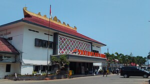
Tanjung Karang railway station
Railway station in Indonesia
Distance: Approx. 3248 meters
Latitude and longitude: -5.4088642,105.2599558
Tanjung Karang Station (TNK) (alternatively Tanjungkarang Station) is a large type A railway station located in Enggal District, Bandar Lampung, Lampung, Indonesia. The station is located at an altitude of +96 meters and is operated by the Regional Division IV Tanjungkarang of Kereta Api Indonesia. The station served as starting point for passenger trains heading for Kertapati Station in Palembang.
Weather in this IP's area
light rain
24 Celsius
25 Celsius
24 Celsius
24 Celsius
1010 hPa
92 %
1010 hPa
999 hPa
10000 meters
1.32 m/s
1.53 m/s
230 degree
78 %
05:32:55
17:52:01

