Country:
Region:
City:
Latitude and Longitude:
Time Zone:
Postal Code:
IP information under different IP Channel
ip-api
Country
Region
City
ASN
Time Zone
ISP
Blacklist
Proxy
Latitude
Longitude
Postal
Route
Luminati
Country
ASN
Time Zone
Asia/Shanghai
ISP
rainbow network limited
Latitude
Longitude
Postal
IPinfo
Country
Region
City
ASN
Time Zone
ISP
Blacklist
Proxy
Latitude
Longitude
Postal
Route
db-ip
Country
Region
City
ASN
Time Zone
ISP
Blacklist
Proxy
Latitude
Longitude
Postal
Route
ipdata
Country
Region
City
ASN
Time Zone
ISP
Blacklist
Proxy
Latitude
Longitude
Postal
Route
Popular places and events near this IP address

Potong Pasir MRT station
Mass Rapid Transit station in Singapore
Distance: Approx. 610 meters
Latitude and longitude: 1.331161,103.869058
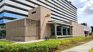
Potong Pasir MRT station is an underground Mass Rapid Transit (MRT) station on the North East line (NEL) in Toa Payoh planning area, Singapore. It is situated underneath Upper Serangoon Road at the junction with Potong Pasir Avenue 1 and Wan Tho Avenue. Primarily serving the Potong Pasir residential estate, Potong Pasir station is also close to Saint Andrew's Village, a major cluster of educational institutions that are part of the Saint Andrew's family of schools.

Bidadari Cemetery
Defunct cemetery in Toa Payoh, Singapore
Distance: Approx. 771 meters
Latitude and longitude: 1.335425,103.87200278
Bidadari Cemetery (Malay: Perkuburan Bidadari, lit. Cemetery of the Angels, Chinese: 比达达利坟场) is a defunct cemetery in Singapore. It used to serve the Christian, Muslim, Hindu and Sinhalese communities, and accepted burials between 1907 and 1972.
Cedar Girls' Secondary School
Government, autonomous school in Singapore
Distance: Approx. 614 meters
Latitude and longitude: 1.3343,103.8742
Cedar Girls Secondary School is a government autonomous girls secondary school in Singapore. Established in 1957, it initially offered only a four-year Express course leading to the Singapore-Cambridge GCE Ordinary Level examinations. Starting in 2012, it has partnered with Victoria Junior College to offer a six-year Integrated Programme, which allows students to proceed to Victoria for Year 5 and Year 6 to take the Singapore-Cambridge GCE Advanced Level examinations at the end of 6 Years .
Mount Vernon, Singapore
Small hill in central Singapore
Distance: Approx. 980 meters
Latitude and longitude: 1.3371,103.8769
Mount Vernon (Chinese: 翡珑山; Malay: Gunung Vernon) is a small hill in central Singapore west of Potong Pasir and north of MacPherson Estate. Officially named in 1956, it is circumscribed by Bartley Road, Upper Aljunied Road, Upper Serangoon Road, and Upper Paya Lebar Road. It is named after British Royal Navy Vice Admiral Edward Vernon (1684–1757).
Masjid Sallim Mattar
Mosque in Singapore
Distance: Approx. 878 meters
Latitude and longitude: 1.3255964,103.8812123
Sallim Mattar Mosque (Malay: Masjid Sallim Mattar) is a mosque in Singapore serving the Muslim community in the Macpherson Estate. It organizes madrasahs on Sunday and the Friday Prayer. It is located along Mattar Road opposite Macpherson Primary School.

Geylang Bahru MRT station
Mass Rapid Transit station in Singapore
Distance: Approx. 873 meters
Latitude and longitude: 1.321382,103.871414
Geylang Bahru MRT station is an underground Mass Rapid Transit (MRT) station on the Downtown line in Kallang, Singapore. The station is located under Kallang Bahru, at the junction with Geylang Bahru, hence its name. Nearby developments are largely residential.

Mattar MRT station
Mass Rapid Transit station in Singapore
Distance: Approx. 1002 meters
Latitude and longitude: 1.327223,103.882864
Mattar MRT station is an underground Mass Rapid Transit (MRT) station on the Downtown line (DTL) in Geylang, Singapore. The station is located underneath Mattar Road near the junction of Merpati Road. Surrounding landmarks of the station include Canossa Convent, Masjid Sallim Mattar, Church of St Stephen, and Circuit Road Food Centre.
Sri Siva Durga Temple
Hindu temple in Singapore
Distance: Approx. 862 meters
Latitude and longitude: 1.33177778,103.86685278
Sri Siva Durga Temple (Tamil: ஸ்ரீ சிவதுர்கா கோவில்) is a temple for the god Shiva and Durga who are the presiding deities located in the Potong Pasir subzone of the Toa Payoh planning area, Singapore.
Biblical Graduate School of Theology
BGST partners churches to equip effective ambassadors for Christ in their marketplaces
Distance: Approx. 563 meters
Latitude and longitude: 1.328,103.879
Biblical Graduate School of Theology (BGST) is an evangelical theological seminary in Singapore that partners churches to equip marketplace Christians so that they become effective ambassadors for Christ in their workplaces. The current principal is Lai Pak Wah.

Bidadari, Singapore
Subzone of Toa Payoh Planning Area in Central Region, Singapore
Distance: Approx. 984 meters
Latitude and longitude: 1.3375,103.8725
Bidadari is a housing estate and a subzone of Toa Payoh planning area, in the Central Region of Singapore. The housing estate is situated at the site of the former Bidadari Cemetery, which served Christian, Muslim, Hindu and Sinhalese communities.
Saint Andrew's Village
School in Singapore
Distance: Approx. 1024 meters
Latitude and longitude: 1.331278,103.865139
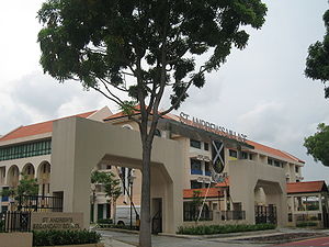
St. Andrew's Village (abbreviation: SAV) is a 13.5 ha school complex located in the Central Region of Singapore. It was officially opened on 26 August 2006, with the ceremony being held at the 1000-seater Cultural Centre in the Junior College.

Alkaff Gardens
Demolished park in Singapore
Distance: Approx. 599 meters
Latitude and longitude: 1.33416667,103.87397222
Alkaff Gardens (also known as the Alkaff Lake Gardens and briefly known as Happy Garden from 1940 to 1941) was a Japanese-style park once located east of the Bidadari Cemetery from 1930 to 1964, on the present site of Cedar Girls' Secondary School at Bidadari, Singapore. In the 1930s, the park was a popular leisure destination for dating couples and families. It featured as its centrepiece an artificial lake, which was drained in 1964.
Weather in this IP's area
light rain
26 Celsius
26 Celsius
26 Celsius
27 Celsius
1009 hPa
89 %
1009 hPa
1007 hPa
10000 meters
3.6 m/s
30 degree
40 %
06:48:10
18:51:29

