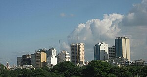
Country:
 Bangladesh
Region:
City:
Latitude and Longitude:
Time Zone:
Postal Code:
IP information under different IP Channel
ip-api
Country
Region
City
ASN
Time Zone
ISP
Blacklist
Proxy
Latitude
Longitude
Postal
Route
IPinfo
Country
Region
City
ASN
Time Zone
ISP
Blacklist
Proxy
Latitude
Longitude
Postal
Route
MaxMind
Country
Region
City
ASN
Time Zone
ISP
Blacklist
Proxy
Latitude
Longitude
Postal
Route
Luminati
Country
BDASN
Time Zone
Asia/Dhaka
ISP
ATS Technology
Latitude
Longitude
Postal
db-ip
Country
Region
City
ASN
Time Zone
ISP
Blacklist
Proxy
Latitude
Longitude
Postal
Route
ipdata
Country
Region
City
ASN
Time Zone
ISP
Blacklist
Proxy
Latitude
Longitude
Postal
Route
Popular places and events near this IP address
Mohakhali
Major neighbourhood of Dhaka
Distance: Approx. 233 meters
Latitude and longitude: 23.777264,90.403492
Mohakhali (Bengali: মহাখালী) is a neighborhood of Dhaka city, the capital of Bangladesh. Mohakhali is one of the busiest places in Dhaka city. Mohakhali is bounded by Banani in the north and Tejgoan area in the south while Gulshan and Niketan is in the east and Mohakhali DOHS to the west.

ICDDR,B
International health research organisation located in Dhaka
Distance: Approx. 621 meters
Latitude and longitude: 23.7764,90.39979722
ICDDR,B (formerly known as the International Centre for Diarrhoeal Disease Research, Bangladesh) is an international health research organisation located in Dhaka, Bangladesh. Dedicated to saving lives through research and treatment, ICDDR,B addresses some of the most critical health concerns facing the world today, ranging from improving neonatal survival to HIV/AIDS. In collaboration with academic and research institutions over the world, ICDDR,B conducts research, training and extension activities, as well as programme-based activities, to develop and share knowledge for global lifesaving solutions. ICDDR,B is one of the leading research institutes of the Global South, releasing, according to the Thomson Reuters Web of Science, 18 percent of the Bangladesh's publications.
Bangladesh College of Physicians and Surgeons
College in Dhaka, Bangalaadesh
Distance: Approx. 704 meters
Latitude and longitude: 23.7775,90.3988
The Bangladesh College of Physicians & Surgeons (BCPS) is a statutory professional membership body in Bangladesh dedicated to improving the practice of medicine and surgery, chiefly through the accreditation of doctors by examination. This institution was established in 1972, by the Bangladesh College of Physicians and Surgeons Order 1972, an ordinance issued by the Hon'ble President of Bangladesh. It organizes examinations for Fellowship (FCPS) and Membership (MCPS).
Government Titumir College
Public college in Dhaka, Bangladesh
Distance: Approx. 429 meters
Latitude and longitude: 23.78138889,90.40416667
Government Titumir College (Bengali: সরকারি তিতুমীর কলেজ) is a public educational institution in Bangladesh. It is located on the A.K. Khandakar Road in the Mohakhali, Dhaka. This college is named after Mir Nesar Ali Titumir, who was killed fighting against British colonial rule.

National Institute of Cancer Research and Hospital
Healthcare organization and hospital in Dhaka, Bangladesh
Distance: Approx. 371 meters
Latitude and longitude: 23.7783,90.4093
National Institute of Cancer Research & Hospital (NICRH) (Bengali: জাতীয় ক্যান্সার গবেষণা ইনস্টিটিউট ও হাসপাতাল) is dedicated to cancer patient management, education and research. This is the only tertiary level center of the country engaged in multidisciplinary cancer patient management. It started its activity in a tin-shade building of Dhaka Medical College and Hospital in 1982, soon it is shifted to the present location at Mohakhali in 1986.

National Institute of Diseases of the Chest and Hospital
Research institute in Dhaka, Bangladesh
Distance: Approx. 337 meters
Latitude and longitude: 23.7776,90.409
National Institute of Diseases of the Chest and Hospital (NIDCH) (Bengali: জাতীয় বক্ষব্যাধি ইনস্টিটিউট ও হাসপাতাল) is a state supported research institute and hospital in Bangladesh. It was established in 1955 as TB Hospital. In 1962 it was upgraded as National Chest Diseases Institute.

BRAC Centre
Headquarters of BRAC , commercial office in Dhaka, Bangladesh
Distance: Approx. 512 meters
Latitude and longitude: 23.779826,90.410217
BRAC Centre is a commercial-use building located in Dhaka, Bangladesh. It is one of the tallest buildings in Dhaka with a height of 64 m (210 ft).The building has 20 floors, which are used for commercial purposes.

Mohakhali Inter District Bus Terminal
Distance: Approx. 698 meters
Latitude and longitude: 23.77295278,90.40136111
Mohakhali Inter District Bus Terminal or Mohakhali Bus Terminal is one of three main inter-city bus stations in Dhaka, opened in 1984. Located in the Mohakhali neighbourhood, it primarily serves destinations in northern Bangladesh, including Tangail, Mymensingh, Netrokona, Jamalpur, Sherpur, Kishoreganj and Bogura. Renovations to the terminal were completed in 2005.
Shanta Pinnacle
A 40-floor skyscraper in Dhaka, Bangladesh
Distance: Approx. 855 meters
Latitude and longitude: 23.7703,90.4075
Shanta Pinnacle (Bengali: শান্তা পিন্যাকেল) is a 152.3 m (500 ft) 40-floor commercial skyscraper in Tejgaon, Dhaka, which is currently under construction. Upon completion, The Pinnacle is set to be the second tallest building in the city, and its first 40-floor building. The tower was approved for construction in September 2018, and is scheduled to be completed by December 2026.

Niketan
Upscale Residential neighbourhood in Dhaka
Distance: Approx. 735 meters
Latitude and longitude: 23.774594,90.412003
Niketan or Niketon (Bengali: নিকেতন, romanised: Niketon) also known as Niketan Residential Area, Gulshan or Niketan Housing Society is an upscale residential neighbourhood in Dhaka, Bangladesh. Niketan is also a part of Gulshan Thana and Ward No. 20 of Dhaka North City Corporation.
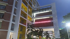
Sheikh Russel National Gastroliver Institute & Hospital
Hospital in Dhaka, Bangladesh
Distance: Approx. 620 meters
Latitude and longitude: 23.776237,90.411543
Sheikh Russel National Gastroliver Institute & Hospital (Bengali: শেখ রাসেল জাতীয় গ্যাস্ট্রোলিভার ইনস্টিটিউট ও হাসপাতাল) is a state supported research institute and hospital for Gastrointestinal diseases of the Digestive System, Liver, and Pancreas located at Mohakhali, Dhaka, Bangladesh.

Mohakhali Flyover
Flyover in Dhaka, Bangladesh
Distance: Approx. 841 meters
Latitude and longitude: 23.7782,90.397452
Mohakhali Flyover (Bengali: মহাখালী উড়ালসেতু) is an overpass located at Mohakhali in Dhaka, the capital of Bangladesh. It is the first flyover completed in Bangladesh. Although the construction of Khilgaon flyover was started first, the construction of Mohakhali flyover was completed earlier and inaugurated before Khilgaon flyover.
Weather in this IP's area
haze
31 Celsius
38 Celsius
31 Celsius
31 Celsius
1004 hPa
84 %
1004 hPa
1002 hPa
3500 meters
3.6 m/s
330 degree
40 %
05:46:25
17:57:17