Country:
 Australia
Region:
City:
Latitude and Longitude:
Time Zone:
Postal Code:
IP information under different IP Channel
ip-api
Country
Region
City
ASN
Time Zone
ISP
Blacklist
Proxy
Latitude
Longitude
Postal
Route
IPinfo
Country
Region
City
ASN
Time Zone
ISP
Blacklist
Proxy
Latitude
Longitude
Postal
Route
MaxMind
Country
Region
City
ASN
Time Zone
ISP
Blacklist
Proxy
Latitude
Longitude
Postal
Route
Luminati
Country
AURegion
nsw
City
sydney
ASN
Time Zone
Australia/Sydney
ISP
Over The Wire Pty Ltd
Latitude
Longitude
Postal
db-ip
Country
Region
City
ASN
Time Zone
ISP
Blacklist
Proxy
Latitude
Longitude
Postal
Route
ipdata
Country
Region
City
ASN
Time Zone
ISP
Blacklist
Proxy
Latitude
Longitude
Postal
Route
Popular places and events near this IP address

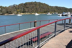
Georges River National Park
National park in Sydney, Australia
Distance: Approx. 1446 meters
Latitude and longitude: -33.98277778,151.02083333
Georges River National Park is a protected Australian National Park, under the management of the NSW National Parks and Wildlife Service. The park falls in the regions of the Sutherland Shire Council and Canterbury-Bankstown Council. Located in the city of Sydney, 25 km south-west of the CBD, surrounded by neighbouring suburbs of Lugano, Illawong, Alfords Point, Padstow Heights, Revesby Heights, Picnic Point and Sandy Point.
Alfords Point
Suburb of Sydney, New South Wales, Australia
Distance: Approx. 1408 meters
Latitude and longitude: -33.9848,151.02142
Alfords Point is a suburb in southern Sydney, in the state of New South Wales, Australia. Alfords Point is 28 kilometres south of the Sydney central business district, within the local government area of the Sutherland Shire. Alfords Point shares the postcode of 2234 with neighbouring suburbs of Menai, Bangor and Illawong.
Peakhurst
Suburb of Sydney, New South Wales, Australia
Distance: Approx. 2323 meters
Latitude and longitude: -33.9654,151.0502
Peakhurst is a suburb in Southern Sydney, or the St George Area, in the state of New South Wales, Australia 21 kilometres south-west of the Sydney central business district. Peakhurst is in the local government area of the Georges River Council. Peakhurst has a western border on Salt Pan Creek, on the Georges River.

Illawong
Suburb of Sydney, New South Wales, Australia
Distance: Approx. 1968 meters
Latitude and longitude: -34.00057,151.03587
Illawong is a suburb in southern Sydney, in the state of New South Wales, Australia. Illawong is located 27 kilometres south of the Sydney Central Business District, in the local government area of the Sutherland Shire in the area commonly called Menai. The post code is 2234, which is also assigned to the contiguous suburbs of Menai, Bangor Barden Ridge and Alfords Point.
Revesby Heights
Suburb of Sydney, New South Wales, Australia
Distance: Approx. 2391 meters
Latitude and longitude: -33.96805556,151.01777778
Revesby Heights, a suburb of local government area City of Canterbury-Bankstown, is 24 kilometres south-west of the Sydney central business district, in the state of New South Wales, Australia. It is a part of the South-western Sydney region. Revesby Heights is located on the northern bank of the Georges River and west of Little Salt Pan Creek.
Padstow Heights
Suburb of Sydney, New South Wales, Australia
Distance: Approx. 1105 meters
Latitude and longitude: -33.97305556,151.035
Padstow Heights, a suburb of local government area of the City of Canterbury-Bankstown, located 22 kilometres south-west of the Sydney central business district, in the state of New South Wales, Australia. It is a part of the South-western Sydney region. Padstow is a separate suburb to the north and One Tree Point is a locality within Padstow Heights.

Peakhurst Heights, New South Wales
Suburb of Sydney, New South Wales, Australia
Distance: Approx. 1356 meters
Latitude and longitude: -33.98166667,151.05111111
Peakhurst Heights is a suburb in southern Sydney, in the state of New South Wales, Australia. Peakhurst Heights is located 22 kilometres south of the Sydney central business district and is part of the St George area. Peakhurst Heights is in the local government area of the Georges River Council.
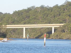
Alfords Point Bridge
Bridge in New South Wales, Australia
Distance: Approx. 826 meters
Latitude and longitude: -33.9774,151.0305
Alfords Point Bridge is a twin 445-metre-long (1,460 ft) concrete and steel box girder road bridge that carries Alford Point Road as state route A6 across the lower Georges River between Padstow Heights in the City of Canterbury-Bankstown and Alfords Point in the Sutherland Shire in Sydney, New South Wales, Australia. The first bridge opened on 7 September 1973. Although the deck was built wide enough to accommodate three lanes of traffic, it carried one lane of traffic in each direction.
Menai High School
Public coeducational school in Illawong, New South Wales, Australia
Distance: Approx. 2516 meters
Latitude and longitude: -34.0029,151.0238
Menai High School is a secondary school in Illawong, a suburb in Sydney's Sutherland Shire.
Lugarno, New South Wales
Suburb of Sydney, New South Wales, Australia
Distance: Approx. 678 meters
Latitude and longitude: -33.98469,151.04352
Lugarno is a suburb situated in the St George area of southern Sydney, in the state of New South Wales, Australia. It is located in the local government area of the Georges River Council, 23 kilometres south of the Sydney central business district. Situated on the northern bank of the Georges River, Lugarno is known for its large areas of bushland.
Boggywell Creek
River in Australia
Distance: Approx. 1525 meters
Latitude and longitude: -33.975,151.05
Boggywell Creek, an urban gully that is part of the Georges River catchment, is located in the southern Sydney district of St George, in New South Wales, Australia.

Oatley Park, New South Wales
Distance: Approx. 2137 meters
Latitude and longitude: -33.981908,151.059616
Oatley Park is a 112 acres (45 ha) reserve located on a promontory jutting into the Georges River in the southern Sydney suburb of Oatley. It is bounded by the Georges River, Lime Kiln Bay, and Jew Fish Bay. The park includes natural bushland, waterways, a children's playground, and an oval.
Weather in this IP's area
clear sky
21 Celsius
20 Celsius
19 Celsius
22 Celsius
1009 hPa
35 %
1009 hPa
1007 hPa
10000 meters
7.2 m/s
260 degree
05:48:19
17:50:27