103.107.179.65 - IP Lookup: Free IP Address Lookup, Postal Code Lookup, IP Location Lookup, IP ASN, Public IP
Country:
Region:
City:
Location:
Time Zone:
Postal Code:
IP information under different IP Channel
ip-api
Country
Region
City
ASN
Time Zone
ISP
Blacklist
Proxy
Latitude
Longitude
Postal
Route
Luminati
Country
ASN
Time Zone
Australia/Sydney
ISP
WSA CO Limited
Latitude
Longitude
Postal
IPinfo
Country
Region
City
ASN
Time Zone
ISP
Blacklist
Proxy
Latitude
Longitude
Postal
Route
IP2Location
103.107.179.65Country
Region
new south wales
City
liverpool
Time Zone
Australia/Sydney
ISP
Language
User-Agent
Latitude
Longitude
Postal
db-ip
Country
Region
City
ASN
Time Zone
ISP
Blacklist
Proxy
Latitude
Longitude
Postal
Route
ipdata
Country
Region
City
ASN
Time Zone
ISP
Blacklist
Proxy
Latitude
Longitude
Postal
Route
Popular places and events near this IP address
Cabramatta, New South Wales
Suburb of Sydney, New South Wales, Australia
Distance: Approx. 730 meters
Latitude and longitude: -33.89444444,150.9375
Cabramatta, also abbreviated as Cabra, is a suburb in South Western Sydney, in the state of New South Wales, Australia. Cabramatta is located 30 kilometres (19 mi) south-west of the Sydney central business district, in the local government area of the City of Fairfield. Cabramatta has been a melting pot for Southeast Asian and European peoples in the latter half of the 20th century.

Warwick Farm Racecourse
Racecourse in Warwick Farm, New South Wales
Distance: Approx. 1637 meters
Latitude and longitude: -33.91083333,150.94527778
Warwick Farm Racecourse is a racecourse at Warwick Farm, a south-west suburb of Sydney, New South Wales, Australia. It is used as a racecourse for Thoroughbred horse racing. The racecourse is owned and operated by the Australian Turf Club.

Warwick Farm railway station
Railway station in Sydney, New South Wales, Australia
Distance: Approx. 1497 meters
Latitude and longitude: -33.91336944,150.9350389
Warwick Farm railway station is a heritage-listed railway station located on the Main Southern line, serving the Sydney suburb of Warwick Farm. It is served by Sydney Trains' T2 Leppington & Inner West Line, T3 Liverpool & Inner West Line and T5 Cumberland line services.

Cabramatta railway station
Railway station in Sydney, New South Wales, Australia
Distance: Approx. 762 meters
Latitude and longitude: -33.8949,150.9388
Cabramatta railway station is located on the Main Southern line, serving the Sydney suburb of Cabramatta. It is served by Sydney Trains' T2 Leppington & Inner West Line, T3 Liverpool & Inner West Line and T5 Cumberland line services.

Canley Vale railway station
Railway station in Sydney, New South Wales, Australia
Distance: Approx. 1745 meters
Latitude and longitude: -33.886889,150.943652
Canley Vale railway station is located on the Main South line, serving the Sydney suburb of Canley Vale. It is served by Sydney Trains' T2 Leppington & Inner West Line and T5 Cumberland line services.
Warwick Farm, New South Wales
Suburb of Sydney, New South Wales, Australia
Distance: Approx. 1598 meters
Latitude and longitude: -33.91395,150.93739
Warwick Farm is a suburb of Sydney, in the state of New South Wales, Australia. Warwick Farm is located 30 kilometres west of the Sydney central business district, in the local government area of the City of Liverpool and is part of the South-western Sydney region.

Canley Heights, New South Wales
Suburb of Sydney, New South Wales, Australia
Distance: Approx. 1749 meters
Latitude and longitude: -33.88502,150.9276
Canley Heights is a suburb of Sydney, in the state of New South Wales, Australia 31 kilometres west of the Sydney central business district, in the local government area of the City of Fairfield and is part of the South-western Sydney region.
Cabramatta High School
School in Australia
Distance: Approx. 383 meters
Latitude and longitude: -33.89972222,150.92916667
Cabramatta High School (abbreviated as CHS) is a public high school located in Cabramatta, a south-western suburb of Sydney, New South Wales, Australia.
Pal College
Private day school in Cabramatta, New South Wales, Australia
Distance: Approx. 771 meters
Latitude and longitude: -33.893965,150.937385
Pal College was an independent school located in Cabramatta, a south-western suburb of Sydney, New South Wales, Australia. Established in 2005 by Seth Pal, Pal College had at one time an enrolment of an estimated 200+ students from Years 7 to 12. Pal College was ranked 97th in the 2008 "Top 200" HSC Schools in New South Wales.

Warwick Farm Raceway
Distance: Approx. 1620 meters
Latitude and longitude: -33.91083333,150.945
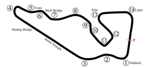
Warwick Farm Raceway was a motor racing facility which was in operation from 1960 to 1973. Warwick Farm Raceway hosted numerous major events during its life such as the Australian Grand Prix and rounds of both the Australian Touring Car Championship and the Tasman Series.
Chipping Norton Lake
Lake in New South Wales, Australia
Distance: Approx. 1543 meters
Latitude and longitude: -33.9,150.95
Chipping Norton Lake is a 49-hectare (120-acre) artificial lake and regional park located in the Sydney suburb of Chipping Norton, New South Wales, Australia. It is a part of the Georges River system. Chipping Norton Lake is managed by Liverpool City Council.
Warwick Farm Racecourse railway station
Former railway station in Sydney, New South Wales, Australia
Distance: Approx. 1631 meters
Latitude and longitude: -33.9131,150.9412
Warwick Farm Racecourse railway station was a railway station on the Warwick Farm Racecourse branch line in Warwick Farm, New South Wales, Australia. The station served the Warwick Farm Racecourse. The station opened on 12 June 1889.
Weather in this IP's area
moderate rain
21 Celsius
22 Celsius
21 Celsius
22 Celsius
1017 hPa
93 %
1017 hPa
1010 hPa
10000 meters
1.79 m/s
3.13 m/s
100 degree
100 %


