103.101.98.23 - IP Lookup: Free IP Address Lookup, Postal Code Lookup, IP Location Lookup, IP ASN, Public IP
Country:
 Bangladesh
Region:
City:
Location:
Time Zone:
Postal Code:
ISP:
ASN:
language:
User-Agent:
Proxy IP:
Blacklist:
IP information under different IP Channel
ip-api
Country
Region
City
ASN
Time Zone
ISP
Blacklist
Proxy
Latitude
Longitude
Postal
Route
db-ip
Country
Region
City
ASN
Time Zone
ISP
Blacklist
Proxy
Latitude
Longitude
Postal
Route
IPinfo
Country
Region
City
ASN
Time Zone
ISP
Blacklist
Proxy
Latitude
Longitude
Postal
Route
IP2Location
103.101.98.23Country
bdRegion
dhaka
City
jamalpur
Time Zone
Asia/Dhaka
ISP
Language
User-Agent
Latitude
Longitude
Postal
ipdata
Country
Region
City
ASN
Time Zone
ISP
Blacklist
Proxy
Latitude
Longitude
Postal
Route
Popular places and events near this IP address

Jamalpur District
District of Bangladesh in Mymensingh
Distance: Approx. 2720 meters
Latitude and longitude: 24.92,89.96
Jamalpur District (Bengali: জামালপুর জেলা) is a district in Bangladesh, part of the Mymensingh Division. It was established in 1978. It has its headquarters in Jamalpur.

Jamalpur Sadar Upazila
Upazila in Mymensingh Division, Bangladesh
Distance: Approx. 2527 meters
Latitude and longitude: 24.91666667,89.95833333
Jamalpur Sadar (Bengali: জামালপুর সদর) is an upazila of Jamalpur District in the Division of Mymensingh, Bangladesh.

Government Ashek Mahmud College
Educational institution in Bangladesh
Distance: Approx. 1766 meters
Latitude and longitude: 24.9324,89.9358
Government Ashek Mahmud College, Jamalpur is an institution of higher education in Bangladesh, located in the Jamalpur District.

Jamalpur Stadium
Stadium in Bangladesh
Distance: Approx. 2201 meters
Latitude and longitude: 24.93644167,89.93455278
Jamalpur Stadium also known as Beer Muktijoddha Advocate Abdul Hakim Stadium( Bangla: বীর মুক্তিযোদ্ধা এডভোকেট আব্দুল হাকিম স্টেডিয়াম) is located by the Jamalpur Police Lines, beside Jamalpur-Melandaha Road, Jamalpur, Bangladesh. The stadium is used mainly for national day parade, domestic football and cricket leagues and other cultural events.

Jamalpur Science and Technology University
Public university in Jamalpur, Bangladesh
Distance: Approx. 9489 meters
Latitude and longitude: 24.9574,89.8507
Jamalpur Science & Technology University (Bengali: জামালপুর বিজ্ঞান ও প্রযুক্তি বিশ্ববিদ্যালয়) is a government financed public university of Bangladesh. It is established on 28 November 2017 vide act no 24 of 2017 as the 44th public university of Bangladesh. Later it was renamed at 2024 as Jamalpur Science & Technology University.
Jamalpur Zilla School
Public High School in Bangladesh
Distance: Approx. 2067 meters
Latitude and longitude: 24.9331,89.9429
Jamalpur Zilla School is a public high school in Jamalpur District and one of the oldest schools in Bangladesh.

Jamalpur-5
Constituency of Bangladesh's Jatiya Sangsad
Distance: Approx. 1628 meters
Latitude and longitude: 24.93,89.94
Jamalpur-5 is a constituency represented in the Jatiya Sangsad (National Parliament) of Bangladesh since 2024 by Md Abul Kalam Azad of the Awami League.
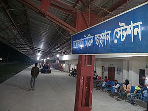
Jamalpur Town Junction railway station
Distance: Approx. 2091 meters
Latitude and longitude: 24.9152996,89.9539535
Jamalpur Town Junction Railway Station is a junction railway located on Narayanganj–Bahadurabad Ghat line and Jamalpur-Bangabandhu Bridge East line. The station located in Jamalpur. The station opened on 3 November 1894.
Weather in this IP's area
clear sky
18 Celsius
17 Celsius
18 Celsius
18 Celsius
1012 hPa
36 %
1012 hPa
1010 hPa
10000 meters
1.8 m/s
1.83 m/s
53 degree