Country:
 Australia
Region:
City:
Latitude and Longitude:
Time Zone:
Postal Code:
IP information under different IP Channel
ip-api
Country
Region
City
ASN
Time Zone
ISP
Blacklist
Proxy
Latitude
Longitude
Postal
Route
IPinfo
Country
Region
City
ASN
Time Zone
ISP
Blacklist
Proxy
Latitude
Longitude
Postal
Route
MaxMind
Country
Region
City
ASN
Time Zone
ISP
Blacklist
Proxy
Latitude
Longitude
Postal
Route
Luminati
Country
AURegion
vic
City
melbourne
ASN
Time Zone
Australia/Melbourne
ISP
TPG Telecom Limited
Latitude
Longitude
Postal
db-ip
Country
Region
City
ASN
Time Zone
ISP
Blacklist
Proxy
Latitude
Longitude
Postal
Route
ipdata
Country
Region
City
ASN
Time Zone
ISP
Blacklist
Proxy
Latitude
Longitude
Postal
Route
Popular places and events near this IP address
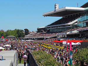
Flemington Racecourse
Horse racing venue in Flemington, Melbourne, Victoria, Australia
Distance: Approx. 560 meters
Latitude and longitude: -37.79027778,144.9125
Flemington Racecourse is a major horse racing venue located in Melbourne, Victoria, Australia. It is most notable for hosting the Melbourne Cup, which is the world's richest handicap and the world's richest 3200-metre horse race. The racecourse is situated on low alluvial flats, next to the Maribyrnong River.

Ascot Vale, Victoria
Suburb of Melbourne, Victoria, Australia
Distance: Approx. 893 meters
Latitude and longitude: -37.779,144.919
Ascot Vale is an inner-city suburb in Melbourne, Victoria, Australia, 5 km (3.1 mi) north-west of Melbourne's Central Business District, located within the City of Moonee Valley local government area. Ascot Vale recorded a population of 15,197 at the 2021 census. Ascot Vale is bounded in the west by the Maribyrnong River, in the north by Maribyrnong and Ormond Roads, in the east by the Moonee Ponds Creek, and in the south by Lyons Road, Epsom Road to the railway line thence generally north-east to Moonee Ponds Creek.

Showgrounds railway station, Melbourne
Railway station in Melbourne, Australia
Distance: Approx. 439 meters
Latitude and longitude: -37.7834,144.9149
Showgrounds railway station is a commuter railway station on the Flemington Racecourse line, which is part of the Melbourne railway network. It serves the Melbourne Showgrounds and suburb of Flemington, in Melbourne, Victoria, Australia. Showgrounds station is a ground level unstaffed station, featuring one side platform.

Flemington Racecourse railway station
Railway station in Melbourne, Victoria, Australia
Distance: Approx. 923 meters
Latitude and longitude: -37.7879,144.9068
Flemington Racecourse railway station is a commuter railway station and the terminus of the Flemington Racecourse line, which is part of the Melbourne railway network. It serves Flemington Racecourse and the suburb of Flemington, in Melbourne, Victoria, Australia. Flemington Racecourse station is a ground level unstaffed station, featuring two side platforms.

Newmarket railway station, Melbourne
Railway station in Melbourne, Australia
Distance: Approx. 1038 meters
Latitude and longitude: -37.7873,144.929
Newmarket railway station is a commuter railway station on the Craigieburn line, which is part of the Melbourne railway network. It serves the northern suburb of Flemington, in Melbourne, Victoria, Australia. Newmarket station is an elevated unstaffed station, featuring two side platforms.

Melbourne Showgrounds
Event venue in Melbourne, Australia
Distance: Approx. 725 meters
Latitude and longitude: -37.78277778,144.91083333
Melbourne Showgrounds is located in the inner north-western suburb of Ascot Vale, Victoria, Australia, next door to Flemington Racecourse. The largest and most flexible indoor/outdoor venue space in Melbourne the Showgrounds is the home of the annual Melbourne Royal Show, as well as major exhibitions, trade shows, and music concerts, including the Supanova Pop Culture Expo, the Caravan & Camping Touring Supershow and MotoExpo. The venue has also been the selected site for TV and film production and is the current filming location for MasterChef Australia.

Flemington, Victoria
Suburb of Melbourne, Victoria, Australia
Distance: Approx. 973 meters
Latitude and longitude: -37.785,144.928
Flemington is an inner-city suburb in Melbourne, Victoria, Australia, 5 km (3.1 mi) north-west of Melbourne's Central Business District, located within the Cities of Melbourne and Moonee Valley local government areas. Flemington recorded a population of 7,025 at the 2021 census. Flemington is located between the Maribyrnong River and the Moonee Ponds Creek and includes the locality of Newmarket, in which the main commercial area Racecourse Road is located.

Kensington Community High School
Specialpurpose school in Kensington, Victoria, Australia
Distance: Approx. 1254 meters
Latitude and longitude: -37.78805556,144.93138889
Kensington Community High School is a high school in Melbourne, Australia.
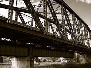
Saltwater River Rail Bridge
Bridge in Victoria, Australia
Distance: Approx. 1274 meters
Latitude and longitude: -37.79833333,144.91649722
The Saltwater River Rail Bridge is a large steel arch truss railway bridge completed in 1858 and crossing the Maribyrnong River (formerly Saltwater River) on the Melbourne to Footscray railway in Melbourne, Victoria. It had the longest span of any bridge in Victoria for thirty years.
Electoral district of Flemington
State electoral district of Victoria, Australia (1955–1967)
Distance: Approx. 961 meters
Latitude and longitude: -37.78472222,144.92777778
Flemington was an electoral district of the Victorian Legislative Assembly. It was created in 1904 with the abolition of Essendon and Flemington. The new seat was won by the former Labor member for the abolished seat, Edward Warde.

Kensington Town Hall, Melbourne
Building in Victoria, Australia
Distance: Approx. 1042 meters
Latitude and longitude: -37.78944444,144.92861111
Kensington Town Hall is a former municipal hall in Kensington, Victoria, Australia. The classical style building, located in Bellair Street was first constructed in 1901. During World War II, it was used as a command post.

Flemington Post Office
Historic site in Victoria, Australia
Distance: Approx. 1284 meters
Latitude and longitude: -37.7872,144.9318
Flemington Post Office is a heritage-listed post office at 2A Wellington Street, Flemington, Victoria, Australia. It was added to the Australian Commonwealth Heritage List on 8 November 2011.
Weather in this IP's area
clear sky
12 Celsius
11 Celsius
10 Celsius
13 Celsius
1019 hPa
71 %
1019 hPa
1018 hPa
10000 meters
4.12 m/s
10 degree
06:42:12
19:32:12