Country:
 Australia
Region:
City:
Latitude and Longitude:
Time Zone:
Postal Code:
IP information under different IP Channel
ip-api
Country
Region
City
ASN
Time Zone
ISP
Blacklist
Proxy
Latitude
Longitude
Postal
Route
IPinfo
Country
Region
City
ASN
Time Zone
ISP
Blacklist
Proxy
Latitude
Longitude
Postal
Route
MaxMind
Country
Region
City
ASN
Time Zone
ISP
Blacklist
Proxy
Latitude
Longitude
Postal
Route
Luminati
Country
AURegion
vic
City
melbourne
ASN
Time Zone
Australia/Melbourne
ISP
TPG Telecom Limited
Latitude
Longitude
Postal
db-ip
Country
Region
City
ASN
Time Zone
ISP
Blacklist
Proxy
Latitude
Longitude
Postal
Route
ipdata
Country
Region
City
ASN
Time Zone
ISP
Blacklist
Proxy
Latitude
Longitude
Postal
Route
Popular places and events near this IP address

Fawkner Park, Melbourne
Park in South Yarra, Melbourne, Australia
Distance: Approx. 185 meters
Latitude and longitude: -37.841,144.982
Fawkner Park is a popular park in Melbourne's South Yarra and part of the City of Melbourne. It provides recreational areas for teams playing Cricket, Softball, Soccer, Australian Rules Football, Tennis,Quadball and Rugby.

The Alfred Hospital
Hospital in Victoria, Australia
Distance: Approx. 609 meters
Latitude and longitude: -37.8461,144.9827
The Alfred Hospital, (also known as The Alfred or Alfred Hospital) is a leading tertiary hospital in Melbourne, Victoria. It is the second oldest hospital in Victoria after Melbourne Hospital which is still operating on its original site. The hospital is one of two major adult trauma centers in Victoria and houses the largest intensive care unit in Australia.

Melbourne Hebrew Congregation
Jewish Congregation in Australia
Distance: Approx. 589 meters
Latitude and longitude: -37.8365,144.9766
The Melbourne Hebrew Congregation (Hebrew: ק"ק שארית ישראל), or Toorak Shule, is the oldest Jewish congregation in Melbourne, Victoria, Australia. Formed in 1841, the congregation was originally located on Bourke Street before moving in 1930 to Toorak Road, South Yarra.
Baker Heart and Diabetes Institute
Distance: Approx. 607 meters
Latitude and longitude: -37.84583333,144.98333333
The Baker Heart and Diabetes Institute, commonly known as the Baker Institute, is an Australian independent medical research institute headquartered in Melbourne, Victoria. Established in 1926, the institute is one of Australia's oldest medical research organisations with a historical focus on cardiovascular disease. In 2008, it became the country's first medical research institute to target diabetes, heart disease, obesity and their complications at the basic, clinical and population health levels.

Albert Cricket Ground
Distance: Approx. 511 meters
Latitude and longitude: -37.84527778,144.9775
Albert Cricket Ground, also known as the Albert Reserve and previously as the Warehouseman's Cricket Ground, is a cricket ground in St Kilda, Victoria. It is operated by the Melbourne Cricket Club (MCC), and used as its primary home ground in the Victorian Premier Cricket competition.
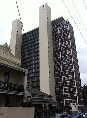
Domain Park Flats
Distance: Approx. 783 meters
Latitude and longitude: -37.83444444,144.98277778
Domain Park Flats (also referred to as Domain Park Apartments and Domain Park Towers) is a 20-storey residential building in Melbourne, Australia, completed in 1962. The block was designed by influential architect Robin Boyd CBE, one of the foremost proponents for the International Modern Movement in Australian architecture and recipient of the RAIA Gold Medal in 1969.

Yarrabee Flats
Building in Victoria, Australia
Distance: Approx. 654 meters
Latitude and longitude: -37.836906,144.98511
Yarrabee Flats is a building located at 44 Walsh street, South Yarra, Melbourne, Australia consisting of five flats. Built in 1940. it was designed by the Australian architecture firm, Romberg & Shaw, (Mary Turner Shaw and Frederick Romberg) and is known for introducing European Modernist architecture into flat development in Melbourne.
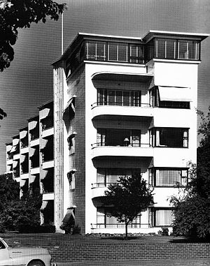
Newburn Flats
Building in Melbourne, Australia
Distance: Approx. 405 meters
Latitude and longitude: -37.842861,144.975866
Newburn Flats is an apartment building located at 30 Queens Road, Melbourne. It is considered one of the first examples of European Modernist ideals applied to multi-unit residences in Australia. It was designed by the firm Romberg & Shaw (Frederick Romberg and Mary Turner Shaw) in 1939 and completed in 1941.
1973 Murphy raids
Terrorism-related operation in Australia
Distance: Approx. 126 meters
Latitude and longitude: -37.84141667,144.97852778
The Murphy raids on the offices of the Australian Security Intelligence Organisation (ASIO) occurred on 16 March 1973. The purpose of the raids, instigated by Attorney-General Lionel Murphy, was to obtain terrorism-related information that the ASIO was accused of withholding. Murphy was operating without any permission from the Prime Minister at the time, Gough Whitlam or the Cabinet.

Sheridan Close Apartment Block
Distance: Approx. 210 meters
Latitude and longitude: -37.8425,144.9783
Sheridan Close is a low-rise apartment complex situated on 485–489 St Kilda Road, Melbourne, Victoria, Australia. It has direct access onto Fawkner Park at the rear of the building. It was designed by the architect Sir Bernard Evans, who later became Lord Mayor of Melbourne (between 1959 and 1961), and was built by Prentice Builders.
The Photographers' Gallery and Workshop
Australian photography gallery in Melbourne 1973–2010
Distance: Approx. 536 meters
Latitude and longitude: -37.841472,144.985983
The Photographers' Gallery and Workshop (1973–2010) was an Australian photography gallery established in South Yarra, Melbourne, and which ran almost continuously for nearly 40 years. Its representation, in the 1970s and 1980s, of contemporary and mid-century, mostly American and some European original fine prints from major artists was influential on Australian audiences and practitioners, while a selection of the latter's work sympathetic to the gallery ethos was shown alternately and then dominated the program.

Christ Church, South Yarra
Anglican church in Melbourne
Distance: Approx. 594 meters
Latitude and longitude: -37.838636,144.98589
Christ Church, South Yarra is an Anglican church at 683-701 Punt Road, South Yarra in Melbourne, Victoria, Australia. Established in 1856, the congregation form part of the Anglican Diocese of Melbourne. The parish belongs to the Anglo-Catholic or High Church tradition; it was the location of the ordination of the first woman to be a deaconess in Australia in 1884.
Weather in this IP's area
clear sky
11 Celsius
10 Celsius
9 Celsius
13 Celsius
1019 hPa
65 %
1019 hPa
1017 hPa
10000 meters
3.21 m/s
8.25 m/s
8 degree
06:41:54
19:31:59