Country:
 Australia
Region:
City:
Latitude and Longitude:
Time Zone:
Postal Code:
IP information under different IP Channel
ip-api
Country
Region
City
ASN
Time Zone
ISP
Blacklist
Proxy
Latitude
Longitude
Postal
Route
IPinfo
Country
Region
City
ASN
Time Zone
ISP
Blacklist
Proxy
Latitude
Longitude
Postal
Route
MaxMind
Country
Region
City
ASN
Time Zone
ISP
Blacklist
Proxy
Latitude
Longitude
Postal
Route
Luminati
Country
AURegion
nsw
City
sydney
ASN
Time Zone
Australia/Sydney
ISP
TPG Telecom Limited
Latitude
Longitude
Postal
db-ip
Country
Region
City
ASN
Time Zone
ISP
Blacklist
Proxy
Latitude
Longitude
Postal
Route
ipdata
Country
Region
City
ASN
Time Zone
ISP
Blacklist
Proxy
Latitude
Longitude
Postal
Route
Popular places and events near this IP address

Vaucluse, New South Wales
Suburb of Sydney, New South Wales, Australia
Distance: Approx. 371 meters
Latitude and longitude: -33.85583333,151.27111111
Vaucluse is an eastern suburb of Sydney, in the state of New South Wales, Australia. It is located 8 kilometres (5 mi) east of the Sydney central business district, in the local government areas of Waverley Council and the Municipality of Woollahra. Vaucluse is located on the South Head peninsula, just South of The Gap with Sydney Harbour on the west and the Tasman Sea to the east.
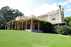
Vaucluse House
Heritage house in Sydney, Australia
Distance: Approx. 269 meters
Latitude and longitude: -33.855512,151.2736407
Vaucluse House is a heritage-listed residence, colonial farm and country estate and now tourist attraction, house museum and public park, formerly the home of statesman William Charles Wentworth and his family. It is located at 69a Wentworth Road, Vaucluse in the Municipality of Woollahra local government area of New South Wales, Australia. Completed between 1803 and 1839 in the Gothic Revival style, its design was attributed to W. C. Wentworth and built by Sir Henry Browne Hayes and W. C. Wentworth.
Vaucluse High School
School in Australia
Distance: Approx. 883 meters
Latitude and longitude: -33.85861111,151.28027778
Vaucluse High School (VHS), formerly known from 1960 to 1981 as Vaucluse Boys' High School (VBHS), is a former public co-educational secondary day school that was, until its closure, located in Vaucluse, an eastern suburb of Sydney, New South Wales, Australia. In 2006 the school was merged with Dover Heights Girls High School to form the Rose Bay Secondary College.

Vaucluse Bay Range Front Light
Lighthouse in New South Wales, Australia
Distance: Approx. 397 meters
Latitude and longitude: -33.84955833,151.27391944
Vaucluse Bay Range Front Light is an active lighthouse located on the east side of the entrance to Vaucluse Bay in Vaucluse, New South Wales, Australia. It serves as the front range light (Vaucluse Bay Range Rear Light serving as the rear light) into Vaucluse Bay. The distance between the lights is 945 metres (3,100 ft).
Vaucluse Bay Range Rear Light
Lighthouse in New South Wales, Australia
Distance: Approx. 568 meters
Latitude and longitude: -33.85818611,151.27293889
Vaucluse Bay Range Rear Light is an active lighthouse located on the east side of the entrance to Vaucluse Bay in Vaucluse, New South Wales, Australia. It serves as the rear range light companion to the Vaucluse Bay Range Front Light, into Vaucluse Bay. The distance between the two lights is 945 metres (3,100 ft).

Strickland House, Vaucluse
Historic site in New South Wales, Australia
Distance: Approx. 597 meters
Latitude and longitude: -33.8559,151.2679
Strickland House is a heritage-listed former residence and convalescent home and now functions, film studio, urban park and visitor attraction located at 52 Vaucluse Road, Vaucluse in the Municipality of Woollahra local government area of New South Wales, Australia. It was designed by John Frederick Hilly and built from 1830 to 1858 by William Wentworth. It is also known as Carrara; Strickland Convalescent Home for Women; Strickland House Hospital for the Aged.

Greycliffe House
House in New South Wales, Australia
Distance: Approx. 664 meters
Latitude and longitude: -33.8518,151.2664
Greycliffe House is an historic, two-storey residential dwelling situated in the Sydney suburb of Vaucluse, New South Wales, Australia. Completed in c. 1852 in the Victorian Rustic Gothic style, Greycliffe is listed on the (now defunct) Australian Register of the National Estate and on the Municipality of Woollahra local government heritage list.

The Hermitage, Vaucluse
House in New South Wales, Australia
Distance: Approx. 788 meters
Latitude and longitude: -33.8593,151.2693
The Hermitage is a historic house in the Sydney suburb of Vaucluse, New South Wales, Australia. It is listed on the (now defunct) Australian Register of the National Estate as well as the Municipality of Woollahra local government heritage list.

Nielsen Park
Heritage-listed historic site at Greycliffe Avenue in New South Wales, Australia
Distance: Approx. 612 meters
Latitude and longitude: -33.8521,151.2669
Nielsen Park is a heritage-listed historic site, park and nature reserve located at Greycliffe Avenue, Vaucluse in the Municipality of Woollahra local government area of New South Wales, Australia. The traditional lands of the Birrabirragal people, the park was designed by John Frederick Hilly, James Barnet and the Office of the New South Wales Government Architect. It is also known as Vaucluse Estate, Greycliffe Estate and Greycliffe House.
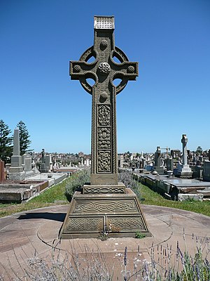
South Head General Cemetery
Historic site in New South Wales, Australia
Distance: Approx. 967 meters
Latitude and longitude: -33.8584,151.2817
The South Head General Cemetery is a heritage-listed cemetery located at 793 Old South Head Road, Vaucluse, New South Wales, Australia. It was built from 1845 to 1950. It is also known as Old South Head Cemetery and the South Head Cemetery.

Wentworth Mausoleum
Historic site in New South Wales, Australia
Distance: Approx. 222 meters
Latitude and longitude: -33.8516,151.275
Wentworth Mausoleum is a heritage-listed mausoleum located at 5 Chapel Road, Vaucluse in the Municipality of Woollahra local government area of New South Wales, Australia. It was built from 1872 to 1874 by Mansfield Brothers, architects. It is also known as Wentworth Mausoleum and site.

Wentworth Memorial Church
Church in New South Wales, Australia
Distance: Approx. 266 meters
Latitude and longitude: -33.8513,151.2753
Wentworth Memorial Church is a heritage-listed former Anglican church building located at 32B Fitzwilliam Road, Vaucluse, Sydney, Australia. It was designed by Clarke Gazzard and Partners and built by Monteith Constructions, with Miller Milston and Ferris as engineers. The property is privately owned; and was formerly owned by the Anglican Diocese of Sydney.
Weather in this IP's area
overcast clouds
14 Celsius
13 Celsius
12 Celsius
15 Celsius
1024 hPa
79 %
1024 hPa
1021 hPa
10000 meters
3.88 m/s
5.18 m/s
52 degree
99 %
06:19:48
19:03:45