Country:
 Australia
Region:
City:
Latitude and Longitude:
Time Zone:
Postal Code:
IP information under different IP Channel
ip-api
Country
Region
City
ASN
Time Zone
ISP
Blacklist
Proxy
Latitude
Longitude
Postal
Route
IPinfo
Country
Region
City
ASN
Time Zone
ISP
Blacklist
Proxy
Latitude
Longitude
Postal
Route
MaxMind
Country
Region
City
ASN
Time Zone
ISP
Blacklist
Proxy
Latitude
Longitude
Postal
Route
Luminati
Country
AURegion
nsw
City
sydney
ASN
Time Zone
Australia/Sydney
ISP
TPG Telecom Limited
Latitude
Longitude
Postal
db-ip
Country
Region
City
ASN
Time Zone
ISP
Blacklist
Proxy
Latitude
Longitude
Postal
Route
ipdata
Country
Region
City
ASN
Time Zone
ISP
Blacklist
Proxy
Latitude
Longitude
Postal
Route
Popular places and events near this IP address
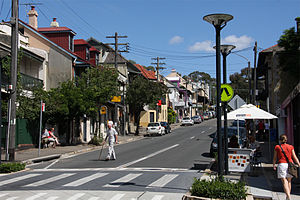
Balmain, New South Wales
Suburb of Sydney, New South Wales, Australia
Distance: Approx. 292 meters
Latitude and longitude: -33.85895,151.17906
Balmain is a suburb in the Inner West of Sydney, New South Wales, Australia. Balmain is located two kilometres (1+1⁄4 miles) west of the Sydney central business district, in the local government area of the Inner West Council. It is located on the Balmain peninsula surrounded by Port Jackson, adjacent to the suburbs of Rozelle to the south-west, Birchgrove to the north-west, and Balmain East to the east.

Dry Dock Hotel
Australian pub in New South Wales, Australia
Distance: Approx. 446 meters
Latitude and longitude: -33.85481,151.182641
The Dry Dock Hotel is a heritage-listed pub located in Balmain, a suburb in the inner west region of Sydney, in the state of New South Wales, Australia. The pub is the oldest licensed hotel in Balmain and one of a number of establishments which formed an integral part of the shipbuilding and industrial heritage of the local area.

Royal Oak Hotel
Australian pub in New South Wales, Australia
Distance: Approx. 368 meters
Latitude and longitude: -33.855656,151.180996
The Royal Oak Hotel is a pub located in Balmain, a suburb in the inner west region of Sydney, in the state of New South Wales, Australia. The pub has historical links with the union movement and is one of a number of buildings which formed an integral part of the shipbuilding and industrial history of the local area.

Balmain Reservoir
Building in Sydney, New South Wales
Distance: Approx. 16 meters
Latitude and longitude: -33.858943,151.18224
The Balmain Reservoir is a 2,376,000-imperial-gallon (10.80 ML) disused, covered reservoir located under Gladstone Park in Balmain, in the Inner West of Sydney, New South Wales, Australia.
Kent Hotel
Distance: Approx. 190 meters
Latitude and longitude: -33.859794,151.180543
The Kent Hotel is a former pub in the inner-western Sydney suburb of Balmain, in the state of New South Wales, Australia. Workers from the nearby Booth's Saw Mill and later Lever and Kitchen, were regular patrons at the hotel. The building is now a private residence but retains a sign with the words The Kent on the front veranda as a reminder of its historic past.

Volunteer Hotel
Distance: Approx. 294 meters
Latitude and longitude: -33.858363,151.185351
The Volunteer Hotel was a pub in the suburb of Balmain in the Inner West of Sydney, in the state of New South Wales, Australia. The pub is named because of its association with a group of volunteer firefighters. The fire bell was located across the road in Darling Street and when it rang, the volunteers would gather and proceed on to the fire.

Lever Brothers Factory
Distance: Approx. 426 meters
Latitude and longitude: -33.86232,151.180406
The Lever Brothers Factory was a soap factory in the suburb of Balmain in Sydney, Australia, which operated from 1895 until 1988. It employed many people from the local area and its large industrial buildings were a prominent feature of the landscape. Most of the site was demolished in 1996 to make way for an apartment complex, and only three of the original buildings remain.

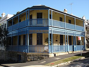
Albion Hotel, Balmain
Distance: Approx. 312 meters
Latitude and longitude: -33.8583056,151.1855313
The Albion Hotel is a former pub in the suburb of Balmain, in the Inner West of Sydney, in the state of New South Wales, Australia. It is currently operated as a trattoria, café and private residence.
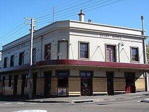
Dick's Hotel
Australian pub in New South Wales, Australia
Distance: Approx. 443 meters
Latitude and longitude: -33.8587364,151.1774215
Dick's Hotel is a pub located in Balmain, a suburb in the inner west region of Sydney, in the state of New South Wales, Australia. The pub was built by John Dick, a local publican of note, in 1872 on the corner of Beattie and Montague Streets. The pub was known as Lean's Hotel from 1886 to 1898 when owned by Jabez Lean, but reverted to its former name after and has remained as such since.

Louisaville
Historic site in New South Wales, Australia
Distance: Approx. 443 meters
Latitude and longitude: -33.8566,151.1862
Louisaville is a heritage-listed residence at 2 Wells Street, Balmain, Inner West Council, Sydney, New South Wales, Australia. It is also known as Inglefield House. It was built by William Carss.
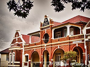
Balmain Hospital Main Building
Historic site in New South Wales, Australia
Distance: Approx. 80 meters
Latitude and longitude: -33.8595,151.182
Balmain Hospital Main Building is a hospital building and former cottage in Balmain, New South Wales, a suburb of Sydney, Australia. It was the original building of and remains the administration building for the Balmain Hospital. It was designed by E. J. Bowen and built in 1880.
Balmain Hospital
Hospital in New South Wales, Australia
Distance: Approx. 130 meters
Latitude and longitude: -33.8596702,151.1831414
Balmain Hospital (formerly Balmain Cottage Hospital and Balmain District Hospital) is a public hospital in the suburb of Balmain in Sydney, Australia. It was founded in 1885 and provides outpatient, rehabilitation, aged care and general practice/casualty services. The hospital commenced operation in 1885 in an adapted cottage, which survives as the hospital's administration building and is now heritage listed.
Weather in this IP's area
overcast clouds
14 Celsius
13 Celsius
12 Celsius
14 Celsius
1024 hPa
81 %
1024 hPa
1020 hPa
10000 meters
1.34 m/s
2.24 m/s
281 degree
100 %
06:20:10
19:04:07