Country:
 Australia
Region:
City:
Latitude and Longitude:
Time Zone:
Postal Code:
IP information under different IP Channel
ip-api
Country
Region
City
ASN
Time Zone
ISP
Blacklist
Proxy
Latitude
Longitude
Postal
Route
IPinfo
Country
Region
City
ASN
Time Zone
ISP
Blacklist
Proxy
Latitude
Longitude
Postal
Route
MaxMind
Country
Region
City
ASN
Time Zone
ISP
Blacklist
Proxy
Latitude
Longitude
Postal
Route
Luminati
Country
AURegion
vic
City
melbourne
ASN
Time Zone
Australia/Melbourne
ISP
TPG Telecom Limited
Latitude
Longitude
Postal
db-ip
Country
Region
City
ASN
Time Zone
ISP
Blacklist
Proxy
Latitude
Longitude
Postal
Route
ipdata
Country
Region
City
ASN
Time Zone
ISP
Blacklist
Proxy
Latitude
Longitude
Postal
Route
Popular places and events near this IP address

Brunswick, Victoria
Suburb of Melbourne, Victoria, Australia
Distance: Approx. 1030 meters
Latitude and longitude: -37.7667,144.9628
Brunswick is an inner-city suburb in Melbourne, Victoria, Australia, 5 km (3.1 mi) north of Melbourne's Central Business District, located within the City of Merri-bek local government area. Brunswick recorded a population of 24,896 at the 2021 census. Traditionally a working class area noted for its large Italian and Greek communities, Brunswick is currently known for its bohemian culture and strong arts and live music scenes.

Jewell railway station
Railway station in Melbourne, Australia
Distance: Approx. 982 meters
Latitude and longitude: -37.775,144.9587
Jewell railway station is a commuter railway station on the Upfield line, which is part of the Melbourne railway network. It serves the northern suburb of Brunswick, in Melbourne, Victoria, Australia. Jewell station is a ground level unstaffed station, featuring two side platforms.

Brunswick railway station, Melbourne
Railway station in Melbourne, Australia
Distance: Approx. 744 meters
Latitude and longitude: -37.7677,144.9597
Brunswick railway station is a commuter railway station on the Upfield line, which is part of the Melbourne railway network. It serves the northern suburb of Brunswick, in Melbourne, Victoria, Australia. Brunswick station is a ground level unstaffed station, featuring two side platforms.
Melbourne Youth Justice Centre
Australian custodial facility for young offenders
Distance: Approx. 1088 meters
Latitude and longitude: -37.77694444,144.94527778
Melbourne Youth Justice Centre (formerly Melbourne Juvenile Justice Centre and Turana Youth Training Centre) is a youth corrections facility located in Parkville, Victoria, Australia. The facility is designed to accommodate 15- to 17-year-old males through four units and a separate multi-purpose unit that houses remand prisoners. Some inmates are slightly older if they were under 18 at the time of their offence.

Brunswick Town Hall
Town hall in Victoria, Australia
Distance: Approx. 903 meters
Latitude and longitude: -37.771732,144.960651
Brunswick Town Hall is located on the corner of Sydney Road and Dawson Street in the inner northern Melbourne suburb of Brunswick, Victoria, Australia.

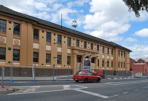
Sydney Road Community School
School in Brunswick, Victoria, Australia
Distance: Approx. 954 meters
Latitude and longitude: -37.77,144.96194444
The Sydney Road Community School is a small government school located on Sydney Road in the Melbourne suburb of Brunswick. It has approximately 100 students from Year 7 to Year 12. Established in 1972 at the height of the alternative education movement, the school has no fees, no uniform and no examinations until Year 12.

City of Brunswick
Local government area in Victoria, Australia
Distance: Approx. 869 meters
Latitude and longitude: -37.767,144.961
The City of Brunswick was a local government area in the inner-northern suburbs of Melbourne, Victoria, Australia. It comprised the suburbs of Brunswick, Brunswick East and Brunswick West. It ceased to exist on 22 June 1994, when its council was disbanded by the Kennett Government and replaced with appointed commissioners, who oversaw its amalgamation with the City of Coburg and parts of the City of Broadmeadows, to create the City of Moreland (now City of Merri-bek).
Electoral district of Brunswick West
Former electoral district in the Victoria, Australia
Distance: Approx. 224 meters
Latitude and longitude: -37.76666667,144.95
The electoral district of Brunswick West was an electorate of the Legislative Assembly in the Australian state of Victoria.
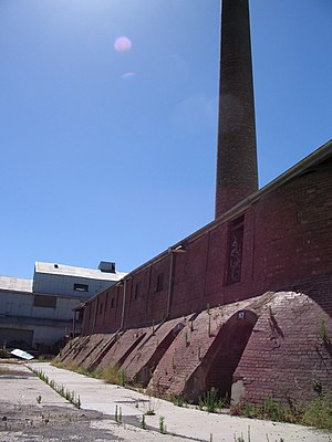
Brunswick brickworks
Australian mechanical brickworks
Distance: Approx. 202 meters
Latitude and longitude: -37.769985,144.952412
The Brunswick Brick Tile & Pottery Company was established in 1870 on a 12-acre paddock on Albert Street Brunswick, as one of the first modern mechanical brickworks in Australia. It was also known as the Hoffman Patent Brick & Tile Company, Hoffman Brickworks, or just ' Hoffman's' for most of its 100 plus years of operation. The Hoffman brickworks was founded by Jenkin Collier and James McKenzie with Messrs Barry Owen and Rourke.

St Ambrose Church, Brunswick
Church in Victoria, Australia
Distance: Approx. 897 meters
Latitude and longitude: -37.77098,144.96095
St Ambrose Church is a Roman Catholic church located on Sydney Road in Brunswick, a suburb of Melbourne, Victoria, Australia.

Brunswick Baptist Church
Church in Victoria, Australia
Distance: Approx. 1021 meters
Latitude and longitude: -37.765534,144.96231
The Brunswick Baptist Church is a Baptist church in 491 Sydney Road, Brunswick, Melbourne, Victoria, Australia. The church is affiliated with the Australian Baptist Ministries.
Brunswick Baths
Building in Melbourne, Australia
Distance: Approx. 799 meters
Latitude and longitude: -37.7711,144.9597
Brunswick Baths is a Victorian Heritage Register listed building in Brunswick, an inner-city suburb of Melbourne, Victoria, Australia. The building was designed in 1913 by architecture firm Peck & Kemter and built in 1914. Peck & Kemter also designed the "Ryder Stand" at Victoria Park, the former home ground of the Collingwood Football Club.
Weather in this IP's area
clear sky
11 Celsius
10 Celsius
9 Celsius
12 Celsius
1018 hPa
71 %
1018 hPa
1012 hPa
10000 meters
4.12 m/s
10 degree
06:42:04
19:32:03