Country:
 Australia
Region:
City:
Latitude and Longitude:
Time Zone:
Postal Code:
IP information under different IP Channel
ip-api
Country
Region
City
ASN
Time Zone
ISP
Blacklist
Proxy
Latitude
Longitude
Postal
Route
IPinfo
Country
Region
City
ASN
Time Zone
ISP
Blacklist
Proxy
Latitude
Longitude
Postal
Route
MaxMind
Country
Region
City
ASN
Time Zone
ISP
Blacklist
Proxy
Latitude
Longitude
Postal
Route
Luminati
Country
AURegion
nsw
City
sydney
ASN
Time Zone
Australia/Sydney
ISP
GSL Networks Pty LTD
Latitude
Longitude
Postal
db-ip
Country
Region
City
ASN
Time Zone
ISP
Blacklist
Proxy
Latitude
Longitude
Postal
Route
ipdata
Country
Region
City
ASN
Time Zone
ISP
Blacklist
Proxy
Latitude
Longitude
Postal
Route
Popular places and events near this IP address

Lane Cove River
River in Sydney, Australia
Distance: Approx. 1009 meters
Latitude and longitude: -33.84233328,151.177333
The Lane Cove River, a northern tributary of the Parramatta River, is a tide-dominated, drowned valley estuary west of Sydney Harbour, located in Sydney, New South Wales, Australia. The river winds through a bushland valley and joins Parramatta River at Greenwich and Woolwich, where together they form an arm of Sydney Harbour, and serves as a border along with Middle Harbour separating Sydney's North Shore.

Greenwich, New South Wales
Suburb of Sydney, New South Wales
Distance: Approx. 180 meters
Latitude and longitude: -33.83302,151.18362
Greenwich is a suburb on the Lower North Shore of Sydney, New South Wales, Australia. Greenwich is located 7 kilometres (4 mi) north-west of the Sydney central business district, in the local government area of the Municipality of Lane Cove. The suburb occupies a peninsula on the northern side of Sydney Harbour, at the opening of the Lane Cove River.

Wollstonecraft, New South Wales
Suburb of Sydney, New South Wales
Distance: Approx. 808 meters
Latitude and longitude: -33.83356,151.19128
Wollstonecraft (UK: , US: ) is a harbourside suburb on the lower North Shore of Sydney, New South Wales, Australia, 4 kilometres north of the Sydney central business district, in the local government area of North Sydney Council.

Wollstonecraft railway station
Railway station in Sydney, New South Wales, Australia
Distance: Approx. 883 meters
Latitude and longitude: -33.832,151.1917
Wollstonecraft railway station is located on the North Shore line, serving the Sydney suburb of Wollstonecraft. It is served by Sydney Trains T1 North Shore line services.

Northwood, New South Wales
Suburb of Sydney, New South Wales, Australia
Distance: Approx. 916 meters
Latitude and longitude: -33.82813,151.17619
Northwood is a suburb on the Lower North Shore of Sydney, in the state of New South Wales, Australia, eight kilometres north-west of the Sydney central business district, in the local government area of the Municipality of Lane Cove. Northwood is on the northern side of the Lane Cove River between Woodford Bay and Gore Creek.
Cockatoo Island ferry wharf
Sydney Ferries ferry wharf
Distance: Approx. 776 meters
Latitude and longitude: -33.83875556,151.17604444
Cockatoo Island ferry wharf is located on Sydney Harbour serving Cockatoo Island.

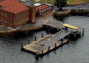
Woolwich ferry wharf
Sydney Ferries ferry wharf
Distance: Approx. 776 meters
Latitude and longitude: -33.83875556,151.17604444
Woolwich ferry wharf (also known as Valentia Street ferry wharf) is located on Sydney Harbour serving the Sydney suburb of Woolwich. It served by Sydney Ferries Cockatoo Island services operating between Circular Quay and Cockatoo Island. The single wharf is served by First Fleet and Emerald class ferries.
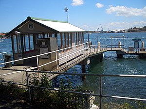
Greenwich Point ferry wharf
Sydney Ferries ferry wharf
Distance: Approx. 868 meters
Latitude and longitude: -33.84204167,151.18072778
Greenwich Point ferry wharf is located on Sydney Harbour serving the Sydney suburb of Greenwich. It served by Sydney Ferries Cockatoo Island services operating between Circular Quay and Cockatoo Island. The single wharf is served by First Fleet and Emerald class ferries.

Berry Island, New South Wales
Place in New South Wales, Australia
Distance: Approx. 830 meters
Latitude and longitude: -33.839745,151.188858
Berry Island is a locality in Wollstonecraft on the lower North Shore of Sydney, New South Wales, Australia. It was originally one of Sydney's Harbour Islands, but it is now connected to the mainland by a constructed isthmus.

Berrys Bay
Bay in Sydney Harbour, Australia
Distance: Approx. 362 meters
Latitude and longitude: -33.83166667,151.18472222
Berrys Bay is a bay located to the east of the Waverton Peninsula and the west of McMahons Point, on the north of Sydney Harbour. A number of ship building firms operate from the bay.

Pallister, Greenwich
Historic site in New South Wales, Australia
Distance: Approx. 764 meters
Latitude and longitude: -33.8277,151.1844
Pallister is a heritage-listed former private girls' school, children's home and country residence and now hospital at 95 River Road, Greenwich, Municipality of Lane Cove, New South Wales, Australia. It is also known as Standish and Greenwich Hospital. The property is owned by Anglican Church Property Trust.

Northwood House, Northwood
Historic site in New South Wales, Australia
Distance: Approx. 758 meters
Latitude and longitude: -33.8281,151.1795
Northwood House is a heritage-listed former home for mentally handicapped children and now residence at 1 Private Road, Northwood in the Lane Cove Council local government area of New South Wales, Australia. It was designed by Edmund Blacket and built during 1878 by John and James Eaton. It is also known as Northwood House & Cottage.
Weather in this IP's area
broken clouds
14 Celsius
14 Celsius
13 Celsius
15 Celsius
1024 hPa
83 %
1024 hPa
1021 hPa
8000 meters
10.29 m/s
160 degree
75 %
06:22:49
19:02:35